Several folks have asked me about the coastal water temperatures, including whether the recent storms have had an impact. So let's take a look!
If you plan to get into the water around here, you better pick up a wet suit, since sea surface temperatures (SSTs) are only in the upper 40s.
The map of current sea surface temperatures (sorry, in °C), shows the cold water along the Northwest Coast (the dark blue color is 9-11°C, 48-53F). The California coast is not particularly warm. You really need to head down to southern Mexico to get pleasantly warm ocean temperatures.
What is even more interesting is whether the water temperatures are warmer or colder than normal and why. To show this, below is the SST difference from normal for October through December. Slightly warmer than normal near the coast, but cooler than normal (blue colors) offshore. Much warmer than normal in a swath extending from Hawaii westward.

But why this pattern, with roughly equal areas of above and below normal temperatures?
Could it be the result of the persistent weather pattern this fall with one strong cyclone after another moving northward a few hundred miles off our coast?
Let's check this out.
The next plot shows the difference of sea-level pressure from normal for October through December. Unusual and persistent low pressure was found to our west. In contrast, higher than normal pressure over Hawaii and westward. The plot thickens!
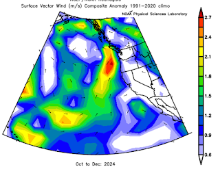
Surface persistent pressure patterns influence the winds, which in turn affects sea surface temperatures. As shown below, low pressure off the coast would tend to cause southerly winds near the Northwest coast (moving warmer water northward), westerly winds north of Hawaii (bringing in warmer water from the west), and northerly winds offshore (causing cooling).

This is NOT the kind of wind field one normally sees with La Nina periods, by the way.


So, what does this portend for the next 30 days or so for the Puget Sound area Cliff?
ReplyDelete