Update Tonight
There is an interesting ultra-local potential twist to this event.... a Hood Canal twist. The storm is going to rapidly weaken and staff as it makes landfall, with it exact location making a big difference on the localized winds.
________________
I have gotten over a dozen emails asking about a potential storm. The amateur sites are going into overdrive talking about the birth of a "monster storm" and other over-the-top descriptions.
So let's examine what the latest model simulations are predicting.
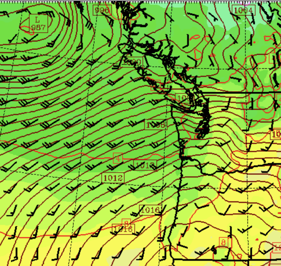
Before I do that, let me note that it was quite windy during the last several hours as a strong trough of low pressure moved through, creating a large north-south pressure difference over western Washington (see model forecast for 7 PM). The solid lines are isobars of constant sea-level pressure.
This large pressure change produced some serious wind gusts (see max wind today below), reaching an impressive 63 mph at Paine Field in Everett. Several thousand customers have lost power.

This is an appetizer for the meteorological buffet tomorrow.
Let me show you a series of forecast maps of sea level pressure for tomorrow. We are close enough in time that this forecast should be reliable.
At 1 PM, an impressive-looking low center, with a central pressure of 982 hPa, is found west of northern Oregon. For some perspective, this is not even close to the central pressure of the "bomb" cyclone in November (which got down to around 940 hPa).


By 7 AM Tuesday, the low had weakened to 1002 hPa and located near Everett.


If this forecast is correct, Puget Sound will not see a major blow.
One thing I have learned about such events is that rapidly weakening lows are rarely big wind producers. Also, the trajectory of the low is not optimal for strong winds over Puget Sound and NW Washington. Too far south.
Looking at the highest winds predicted during this event (below), the northern Oregon coast looks like the place to be for a strong blow, with gusts reaching 65 kt. It's not so exciting over the western WA interior. Gusts to 30-40 mph perhaps.


Hi Cliff, I love your weather blog. I have learned so much from the info you share with your readers. I have a question, can you publish a chart with yearly snow accumulation at Snoqualmie pass over the last 40-50 years? Thank you. Go Dawgs!
ReplyDeleteTry: http://hyak.net/snowfallhist.html
DeleteAgreed. The weakening lows tend to disappoint with wind intensity. A few months back much the same situation happened with a low incoming that was looking potent only to weaken rapidly and winds were rather tame. Models over did the winds. Then we dried out with extended high pressure. I'm looking forward to the easterly anomalies and the inactive phase to subside mid to late March and the westerly anomalies and active phase begin to take over late March and all of April. If next year is a neutral year, it'll be all smiles.
ReplyDelete"It's not so exciting over the western WA interior. Sorry." However can I live with such disappointment? I'm sure I'll cope. I'm being sarcastic of course. Thanks, Cliff.
ReplyDeleteWeirdly, Stanwood/Camano has a gale warning forecast for this afternoon/overnight. I’ll go give our generator a pat just in case.
ReplyDeleteOurs got some use here in Duvall last night. Left it connected, since I know it will likely be needed again. Need to go get some more gas for it today, of course.
DeleteWhy is the NWS forecasting 50mph winds?
ReplyDelete“Gusts to 30-40 mph perhaps” …sir, ground saturation as well as the mass of the humid air means the force of the wind will not be some summer breeze.
ReplyDeleteSome baseball games in Florida were canceled today so I decided to scroll down the radar to see what was happening. Super interesting to see intense storms form on the east side of the gulf and get pushed over land. Nevertheless, I focused the now zoomed-out radar back a little closer to home and it looks like there's a hurricane just offshore. Fortunately for us, it's not a hurricane but it still looks quite impressive (and like something that Florida would be more familiar with). Right now there's a break in the rain but it's fools gold for outdoor activity.
ReplyDeleteA real front (gust front?) came through about 6:30 PM today (Monday). Wind, intense rain, and even some thunder and lightning.
ReplyDeleteDid I forget to mention my location? North Bothell. It was quite intense for 10-15 minutes.
ReplyDeleteHad a mini-blast of serious wind-at least 40mph...and some rain here in S. Everett, around 6:40pm. Only lasted for maybe 15 minutes, but enough to negate my cable TV. Still waiting for that to recover. Life goes on!
ReplyDelete5:30am Tuesday. Bad windstorm on Vashon, entire island without power, looks like similar situation in East Kitsap County.
ReplyDeleteNo power on Bainbridge either
ReplyDeleteThe National Weather Service (NWS) says it recorded 52 mph at SEA Airport, just one mph shy of the strongest gust ever recorded at the airport in 2008.
ReplyDelete