September 03, 2011

Wildfire Season

Due to the high snowpack from our La Nina winter and cools condition extending into July, wildfire season has been delayed over the Northwest; however, recently there has been a significant increase in fire activity, reflecting drier than normal conditions during the past month and belated warming over our region.  And you haven't seen anything yet.

Here is the latest Forest Service map of fire incidents over the region--all of the them are east of the Cascade crest, mainly in Oregon.

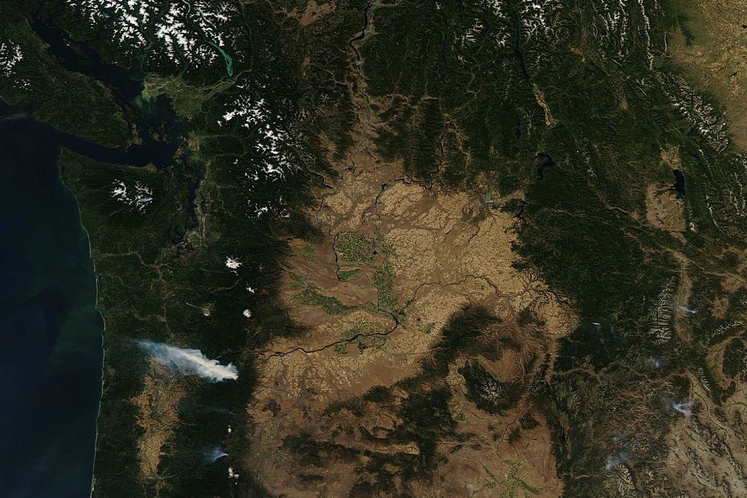
You can see several of the fires on today's MODIS satellite imagery (click to enlarge--necessary to see the smaller fires):


The most prominent smoke plume is not from the largest fire-- the High Cascades fire, which is now encompassing over 100,000 acres near Madras, Oregon--but from the Dollar Lake fire, 16 miles south of Hood River (roughly 3000 acres).  The winds are clearly from the east and you can see the smoke plume moving WNW towards Portland. If you look carefully you can see the smoke from a small fire over the Olympics.

Here is a nice shot of the smoke from north of the Gorge looking south and another near Mt. Hood.


Both of these fires were initiated by lightning strikes.

The local wildfire problem is probably going to get much worse during the middle and end of next week.  No rain is in sight and after a minor cooling on Monday and Tuesday, the heat should really rev up mid-week as the ridge over the western U.S. greatly amplifies into a huge atmospheric blocking pattern.  Here is a sample forecast for next Wednesday...wow.  And there is no end in sight.


 West of the Cascades we should see the entire region (away from the water) moving into the mid-80s, with a number of daily high temperature records falling.

A major concern is that the burnable surface materials ("the fuels") are drying out rapidly.  Here is a Forest Service figure showing you the moisture content of the "1000-hr" fuels---the bigger, thicker branches and debris. Darker red indicate seriously dry fuels and this is only going to get worse.
 A key feature in predicting fires is the thermal tough--a region of low pressure associated with warm air (I blogged about such features last week).   Right now I am doing an intensive study of West Coast thermal troughs with support from the U.S. Forest Service--understanding their generation and movement.  Thermal troughs are associated with a deep, warm air mass that is relatively unstable and enhanced fire danger occurs as such troughs move across the Cascades, with strong winds and upward motion right behind. During the middle of this week an amazing thermal trough is predicted by our high-resolution models.  Want to see?  Here is the predicted sea level pressure and temperature at roughly 2500 ft:


 In short, we are going into one of the warmest September periods we have experienced in a long time and fire danger is getting serious.  The only good thing is that there won't be much lightning. 

September 01, 2011

Upcoming Warmth

During the past few weeks we have had really decent weather--generally dry, with periods of above and below normal temperatures.

Such variability, centered around climatological temperatures, is what normal is all about.
There has been enough sun and warmth for a miracle to happen---I actually have red, ripe tomatoes!  Few pleasures in life are greater.  Here is the proof:


Well, another miracle is occurring...we are going into a warm up period through the weekend and then the heat really revs up on Tuesday and Wednesday as a monster ridge builds up over the western U.S.  And it just stays in place forever.

Right now a weak trough is moving through, bringing increased cloudiness over the region.  Tomorrow (Friday) we should wake up to clouds, but they should break up during the afternoon...low to mid 70s.   But on Saturday ridging aloft develops (see upper level chart) and the temps warm with more sun.  Perhaps a bit warmer on Sunday.
But early in the week ridging really develops (graphic) and temperatures could hit the mid 80s.
And do you see that features in the lower right...another hurricane.  The NWS GFS model has this storm approaching the East Coast late Friday (see forecast for Friday AM below) but the forecast will surely change.  The latest solution gets the hurricane/tropical storm close before it swings to the NE off of New England.


The NWS Climate Prediction Center is suggesting increased probabilities for above normal temperatures through next week. (see graphic).

No fried green tomatoes for me!

Just a reminder...will be starting my KPLU weather segment tomorrow (Friday) at 9 AM...right after birdnote.


Godzilla-Low Pressure, Heavy Rain, and Drifting Snow Ahead for the Pacific Northwest

Northwest meteorological winter is about to begin dramatically.     Heavy rain and massive mountain snows are on the way.  Reservoirs will b...