The Seattle's Times ClimateLab writers have done it again.
Another highly deceptive and error-filled climate story in the ST. One predicting more than a doubling of wildfires over western Washington and Oregon by mid-century.


Before anyone suggests I should not comment on this work, let me note that I am doing research on EXACTLY this topic. I have read all the relevant papers. The authors of this paper cite several of my previous papers on the topic.
The Key Control of Westside Fires Was Ignored
Both this article and the Seattle Times article ignore the central fact about major wildfires occurring west of the Cascade Crest.
Let me explain.
Westside fires are infrequent for a reason: the region west of the Cascade crest is generally too moist to burn. Precipitation is abundant west of the crest (see below) and for most of the year cool, moist marine air from off the Pacific (whose temperature is about 50F) floods over western Washington and Oregon.

Moisture vegetation and ground surfaces, as well as cool/moist air. Wildfires don't have a chance and are thus rare.
But there is an atmospheric "trick" that can make Westside wildfires possible: strong easterly (from the east) winds. Winds that are generally dry and warm, and capable of pushing the moist/cool marine air out to sea.

Virtually all major Westside fires are associated with strong easterly winds.
The air starts relatively dry over eastern Washington and Oregon. As it descends the western slopes of the Cascades and coastal mountains, it is warmed by compression, causing relative humidity to plummet.
The warm, dry air associated with powerful downslope winds can rapidly dry surface fuels, no matter how moist they were days or weeks before. The strong winds can also start fires, by damaging electrical infrastructure. among other ways.
I have looked at every one of the Westside fires of the past 120 years-- all of them were associated with powerful easterly winds.
Examples include the Yacolt Burn near Vancouver, WA in 1902, the Tillamook Fires of the 1930s, and the 2020 fires over western Oregon (there are more). Being a little warmer or drier the days before would have made little difference to these fires: the easterly winds were the key.

Tillamook Burn, Clatsop County Oregon
So if you want to know how Westside fires will change over the next century, you MUST determine how the easterly winds will change.
Unfortunately, the JGR paper does not examine this issue at all. The Seattle Times article ignores the issue as well.
You probably are asking yourself: Will strong easterly winds strengthen or weaken under global warming?
I have examined this question with high-resolution regional climate models (and published the results in the peer-reviewed literature). It appears easterly winds will WEAKEN, which would reduce Westside fires. The Seattle Times article doesn't provide that critical information.
But the problem with the Seattle Times article and paper it cites does not end there.
The paper assumes the same distribution and frequency of fire starts as today and then uses the output from global climate models to see how the fires would change as the earth warms.
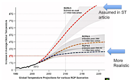
Unfortunately, they used a highly unrealistic and aggressive global warming scenario (RCP 8.5) that greatly exaggerates any global warming impacts.
The global model also is far too coarse to get the local meteorology correct. For example, THERE ARE NO CASCADES in the simulation at all.
Finally, let me note there are many other problems with the paper and even more in the Seattle Times story.
The ClimateLab series in the Seattle Times is pushing incorrect and hyped climate information. The reporters do not evaluate the validity of the exaggerated claims they report. This is not quality journalism and misinforms citizens who need accurate information about climate change.


