April 11, 2024

More Typical Spring Temperatures Will Save Washington and California's Cherry Crop this Year

Last year was a cherry disaster for the West Coast and the key driver was the cool/wet weather late last winter and spring in California.  

This resulted in a very bountiful but late California cherry crop that became available at the same time as the larger Northwest cherry harvest, which was early because of a few warm weeks in May.


With too many cherries available simultaneously, cherry prices plummeted and several Northwest orchards left their cherries on the trees.

Cherry armageddon!

But this year should be much better for cherry growers and lovers of the red fruit such as myself.  

Why?  Because California is warmer this year and the Northwest should be cooler in May.   

A bountiful and extended cherry season is promised.  Let me show you why.

The figure below shows the average temperature for February 1 through April 10 at Modesto, CA (in California's Central Valley) from 1950 through 2024.

 
2023 was way below normal, while this year is near normal.    Thus, the California cherry crop will be earlier this year because of the warmth, and with plenty of rain, there should be a bountiful harvest.  

Typically, the California cherry season runs from mid-May to early June, providing lots of cherries for the Memorial Day holiday weekend.   Expect the same this year.

So what about Washington State?    With El Nino rapidly weakening, there is no reason to expect a major warm period (above normal) in May.   

But what about what has happened in Washington state during the past months?  Below are the average temperatures for Feb. 1 through April 10th for Wenatchee, WA for 1950 through 2024.  

This year's temperatures are slightly above normal and last year was slightly below normal.


At this point, there is no expectation of a May heatwave like last year.  In fact, the latest 46-day forecast from the most skillful system (European Center) suggests cooler-than-normal conditions through the end of May (see forecast below).  That could extend the cherry season into August.


Although my professional expertise is in the area of weather prediction, I will go out on a limb and suggest a bountiful cherry harvest in both California and the Pacific Northwest, and that we will have an extended period of sweet cherries in our food stores.

I can't wait.😁


April 09, 2024

The Surprising Weather "Miracles" of Yesterday's Total Solar Eclipse

The solar eclipse had substantial impacts on local weather, some of which might surprise.

First, many reported a "miracle", with the clouds thinning just before the eclipse.

And the "miracle" was true, but there is a scientific explanation!  But first, let me show you what happened.

Just before the eclipse there were a lot of low clouds over the totality path in northeastern Texas (see blue oval area below)

But during and right after the eclipse, many of the clouds were gone (see below)


Divine intervention?  The influence of the prayers of the astronomically devoted?   

No, it was the result of the weakening solar radiation that caused the surface to cool.  Many of these clouds were shallow convection/cumulus, driven by solar heating (see figure below).  When the sun weakened, so did the clouds.


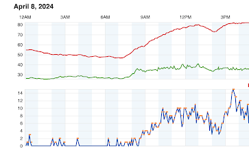
Not surprisingly, surface air temperatures cooled during the eclipse by as much as 5-10F at some locations.  To illustrate, here are the temperatures in Joplin, Missouri, where temperatures went from around 80F to 73F between 12:30 PM and 2 PM, before recovering during the next hour as the sun returned.


And then there was the wind.
  At many locations, there was a dramatic reduction in the wind speed during the eclipse.  Here are the temperatures and winds at another Missouri location (Folly Ridge).  Significant wind reduction during totality (from roughly 10 to 3 mph).


This can be explained by a reduction in vertical mixing in the lower atmosphere. 

Have you ever noticed that during the warm season, winds are greater during the afternoon and weaker at night?    During the day, solar heating at the surface causes vertical mixing, that brings strong winds aloft (not slowed down by the rough surface) down to the surface.  When the sun weakens, the mixing weakens, which reduces the flow of stronger winds to the surface.

Finally, there is another change I am not quite sure I can explain-- so maybe I better be careful about downplaying divine intervention.  

What am I talking about?  Changes in the weather radar imagery.

Consider the radar image from Dallas, Fort Worth, early in the morning (1406 UTC or 9 AM Dallas time).  Not many radar echoes.


Three and a half hours late (12:34 PM), there were lots of weak radar echoes.


But an hour later, near the height of the eclipse, there were few echoes...just like night.


And then an hour later when the sun returned, the echoes were back.


What is going on here?  What are these echoes?  Birds or bugs that like to fly during the day?  I will have to dig into this deeper.

In summary, by greatly changing the heating profile in the lower atmosphere, the eclipse had some profound, but temporary effects on many weather parameters.  


The Stratosphere Plummets over Seattle....and Huge Precipitation Contrasts

Today, the stratosphere was much, much closer to you than normal, and we all lived to tell the tale. As many of you know, the lowest layer o...