While the coastal regions, west of the Cascade and Sierra Crests have been far drier than normal, it has been moister than normal to the east.
Let's go to the data to show what I mean. The maps below will show you the difference from normal (the anomaly) of precipitation over the western U.S. for different periods; these graphics are available from the Western Region Climate Center in Reno, NV.
For the past month (below), western Washington has been ground zero for dry conditions, with western Oregon being right behind. But the situation changes radically over eastern Washington and Oregon, with many areas wetter than normal. Head to Nevada, southern Idaho, and Utah: it is downright moist. And east of the Rockies it is crazy wet.

But that is only for the last 30 days you argue! Fine. How about the past 90 days? (see below). Very similar pattern with eastern WA with above normal precipitation.

Still not convinced that something is going on? Let's check out the last 6 months...basically, the same, except that the California dryness is more severe.
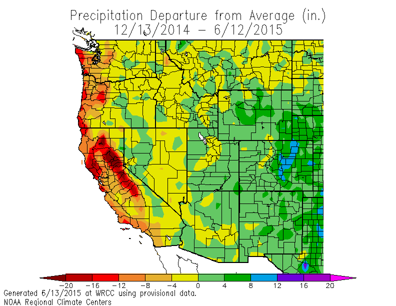
One year? Same thing.

So to properly understand our current water situationm the potential for wildfires this summer, and regional agricultural impacts, one must appreciate that the Cascade crest has separated two different regimes: far dryer than normal over western Washington and Oregon, and wetter than normal to the east.
Thus, it is important that folks in Seattle or Portland, mourning their desiccated gardens and browning grass, don't assume that the same is happened to the east. And it is doubly important that our media and politicians don't make that assumption as well.
You can tell that mother nature knows the correct story in several ways. Take wildfires. We have been told by several media sources that wildfires would hit hard and early this year. Some even said we were in a TINDERBOMB situation. Well, we are well into June-- what has the wildfire season been like this year? Much worst than normal?
Well, let's look at the official U.S. government numbers from the National Interagency Fire Center (see below), which show the number of fires and the number of acres burned from January 1 until now (6/12/15 shown) for the entire country. The western U.S. dominates these statistics. This year 502, 254 acres have burned, the third lowest during the past 11 years, and 1/3 of the average for the previous ten years. Only one fire is burning in the Northwest (a small fire of 103 acres that is not being extinguished--Thunder Creek in North Cascades National Park). So much for a big, early start to the wildfire season. It ain't happening.

We have had a huge amount of lightning and few fires during the last month. Why? Because the ground was too moist. And the moist conditions over eastern Washington have been very helpful to agriculture, reducing the need for irrigation from the rivers hit by the snowpack drought in the Cascades.
The question I am sure you are wondering about is: what about the future? Will the west dry/east moist pattern continue? We can turn to the NOAA/NWS Climate Forecast System model and check out the prediction for the next three months (see below, green and blue are wetter than normal, orange and red are drier). The pattern is predicted to continue this summer.

The bottom line is that understanding the recent precipitation seesaw is very important, with large impacts on agriculture, wildfires, and other other major societal concerns.

.png)


Exactly right, Cliff. Same in BC - the S coast is dry, the Southern Interior is wet. All of the instability seems to be realized along and E of the cascades. Our upper lows this season have been too weak to generate widespread convection W of the mountains and the trend for the next few weeks continues. In 1 month we're in the climatological dry spell where daily POP declines to less than 10%...and stays that way until the end of August.
ReplyDeletePersonally I hope you are right, the Drought monitor says that portions of Eastern WA are in Severe Drought, the cascades in moderate drought, and half of Eastern Oregon is in Extreme drought.
ReplyDeleteWhere is a good Pacific front when we need one?
But what is causing this? Any idea how long until back to normal?
ReplyDeleteI'd wager that warmer than average beats slightly wetter than average in terms of drying and wildfire potential. An extra 0.2 millimeters per day in dry Eastern Washington and Oregon isn't going to help very much when the evaporative demand is generally greater than 0.30 inches (7.62 mm) per day. Granted the Kimberly-Penman reference is for a field of alfalfa and not a mixed ponderosa-pine/doug-fir forest, but I don't think the adjustment will take us too far down. Even then, a major component of the Kimberly-Penman equation is the net radiation (the heat function). If we are warmer than average, then the heat function can easily make up for slightly more moisture in terms of evaporative demand. The Kimberly-Penman equation is also a major reason why I don't buy your claims that all that matters is the amount of precipitation, not the form. My background is in Forestry and Statistics, but I'd wager that a given amount of water in the form of snow does more to extend high soil moisture in our East Slope forests than the same amount of water in the form of rain. Why? Because of the amount of energy that is required to first melt that snow (need I even mention albedo?) before evaporating it.
ReplyDeleteTo speak to your point that the wildfire season has been slightly below or at average to this point so far in the season, I'm going to give you the old stock market caution that past performance does not speak to future returns. Just because we haven't seen a lot of fires yet, doesn't mean it won't be a bad fire season. The high peaks are already melted out. The Enchantments were bombed out this weekend by multitudes of people trying to take advantage of this once-in-a-lifetime low snow-pack to get in and camp before the permanent season starts. I know, because I was up there, and I can tell you that below 6000 or 7000 feet, except for a few well-shaded spots in saddles and drainages, the trail was already dry and dusty when it would normally be muddy.
And while I agree that the word "Tinderbomb" is a bit on the alarmist side, I think it captures another fact of the wildfire threat out there that you haven't addressed. It isn't just that this particular fire season may be hotter and the soils may be drier than usual; it's that our forests are overstocked from decades of fire exclusion. You've only been speaking, about one side of the Fire Weather triangle (Weather, Topography, Fuels). The "Tinderbomb" moniker I think speaks also to the fuels problem out there. I'll let you respond to my critique of the weather piece. But please don't paint it as though we're soaking in monsoon over here. Eastern Washington is always a dry place, a few more millimeters of rain above our normal bone dry average for this time of year isn't going to help wildfire situation much. (I haven't even talked about interception in the forest canopy). Snow matters more than you are giving it credit.
One follow up comment. The fourth-lowest wildfire season in the last 11 years til this point was last year. A wildfire season that saw the largest fire in Washington State history and the one that burned Pateros. I wouldn't be so blithe about saying "there's nothing to worry about."
ReplyDeleteCliff, I love your articles and your blog is on my must read list. I thought I would provide an on-site report from 3.5 miles north of Winthrop. While its true we had a wetter than normal May (1.44-in vs a normal of 1.12-in per the Winthrop 1 wsw station), this amount seems rather slim for drought mitigation purposes. The largest storm did not cause a noticeable increase in the Chewuch river flow. In my opinion all the rain did was cause the fuel load to increase.
ReplyDeleteAfter last weeks heat, the ground has become too dry to pull weeds without a shovel. The vegetation is drying fast and I predict that by the 4th of July it will all be scary dry. Its clearly dry enough now to support wildfires.
Like M. Dalton, forester writing here, too.
ReplyDeleteFire season prediction is even less skilled than weather prediction because there are more variables involved. Weather, sure. Also fuel, which is a function of past vegetation growth and loss. And, critically, ignitions. The driest, most abundant fuel pile won't burn on its own -- something has to ignite the flame. Lightning-ignited fires in the PNW are twice as frequent as human-caused fires, and the average fire size ignited by lighting is larger, too.
Lighting is caused by weather. High upper-level instability and high dew point, i.e., thunderstorms, are positively correlated with lightning-ignited wildfires.
The question I have for Cliff: Is the forecast of higher-than-average moisture this summer on the east-side of the Cascades imply higher-than-average frequency of thunderstorms? If so, we can likely look forward to a vigorous fire season.
To Cliff, and I hope you will reply.
ReplyDeleteSomething occurs to me about the "anomaly" term that we commonly see in writings about weather and climate. Please correct me if I'm wrong, but my understanding is that "anomaly" in the various article refers to departures from some longer-term average. What I don't see mentioned is standard deviation. Therefore, "anomaly" seems to inject a note of alarm into something that often is completely ho-hum.
As an example, one of my cars tells me the my average speed of travel in Seattle is 18 miles an hour. Is it an "anomaly" when I'm able to drive 30 miles an hour on the nearby arterial because there's rare enough traffic to slow anyone down? Is it an "anomaly" when I travel 5 mph (or less) through the intersection of Westlake and Denny in the late afternoon, because it's rush hour at one of the most crowded intersections in the city?
I'm pushing 60 years of age. I was born in the Midwest and lived there for 26 years. I lived on the East Coast for 16 years. I have lived in Seattle for 15 years. I have traveled to all 50 states, and a couple dozen foreign countries. During my life, in various places, I've lived through warm winters in places where winter is normally cold, and have seen some cool summers in places where summers are not normally cool. Lots of snow, no snow. Lots of rain, no rain. And so on.
Webster's defines "anomaly" as deviation from the common rule and something different, abnormal, peculiar, or not easily classified If there is one thing this amateur knows, it's that our country's weather -- and our planet's weather -- is volatile and unruly. I question the use of "anomaly" to denote "departure from average." It seems to me that "anomaly" ought to be departure from a band defined by 2 standard deviations on each side of the average.
When I see "anomaly" used to describe departure from averages of weather or climate, I suspect an attempt to make people scared about what all of us, even amateurs like me, know as "typical crazy weather." What do you say, Cliff?
Cliff<
ReplyDeleteIt is definitely a drought in West Seattle...and Yakima has been hotter than a handheld bottle rocket...
-Rod
Dr Mass, I just saw this today. What is your take on this forecast?
ReplyDeletehttp://www.dailykos.com/story/2015/04/30/1380954/-Super-El-Nino-Likely-as-Huge-Warm-Water-Wave-Hits-West-Coast-Extreme-Marine-Die-Off-Developing#
I'm sorry Professor Mass, but the conditions on the ground don't agree with you...and neither do the fire professionals here in North Central Washington. From today's Wenatchee World:
ReplyDeleteOver the weekend, firefighters battled a 1,060-acre fire in Douglas County near Wells Dam, a 600-acre fire east of Soap Lake, and a 6,700-acre fire near Coulee City.
All of the fires were contained by midday Monday, and causes were still being investigated.
“This is early for the big fires,” said Grant County Fire District 7 Chief Kirk Sheppard. “We’re fighting fires now that we would normally see in August.”
Kirsten,
ReplyDeleteI think those fire reports are bogus...the Wenatchee World reporter may have gotten it wrong. There are no such fires reported by any of the Federal wildfire sites. Can you find any other documentation of these fires? ..cliff
Cliff, that's because these were brush fires handled by county fire departments not forest fires. I don't believe they are reported by the Feds.
ReplyDeleteDoug,
ReplyDeleteThe NWCC reports fires on federal and state lands: http://gacc.nifc.gov/nwcc/
It just seemed really strange that a supposedly large fire (6700 acres) was not reported...cliff
Regarding the drought, it is true that it isn't a precip drought. However, look at this view of current streamflow conditions in Washington. Since the rivers are largely fed by snowmelt in June, this indicates a developing streamflow drought of epic proportion. It will only get worse as the summer goes on. Really really bad for fish and other aquatic life in our rivers.
ReplyDeletehttp://waterdata.usgs.gov/wa/nwis/rt
Here's the article in question on the fires
ReplyDeletehttp://www.wenatcheeworld.com/news/2015/jun/15/fire-season-arrives-with-a-bang/
Doug...that is right....it is not a precip drought, but a snow drought. The streams were higher than normal during the winter and early spring and now are lower than normal. Some record low. The Columbia is not record low. So fish on the Columbia are in better shape than those moving streams in the Olympics...cliff
ReplyDeleteKirsten...I did find discussion of a flashy 1000 acres brush fire that was rapidly put out near Wells... but nothing on a 6700 acres fire near Coulee City.
ReplyDeleteOh, and this just in from the Northwest Fires facebook page at approximately 3:35 p.m. 6/17/15:
ReplyDeleteNew #WaWILDFIRE - 3 miles east of Cheney, WA. Getting reports of 50 acres with rapid rate of spread and structures threatened. Looks like 2 dozers, 2 DNR rotors, Tanker 45, and Mad River Hotshots are assigned. Any other intel out there?
Kirsten,
ReplyDeleteI am NOT saying there aren't some fires out there. But there is no documentation of the 6700 acres fire in that article. That is a large fire and it is not documented on any of the NW wildfire sites. There seem to be a lot flashy grass fires that are rapidly being put out. But no major fires. Can you document the 6700 acre one?....cliff
Cliff, you say
ReplyDelete"You can tell that mother nature knows the correct story in several ways. Take wildfires. We have been told by several media sources that wildfires would hit hard and early this year. Some even said we were in a TINDERBOMB situation. Well, we are well into June-- what has the wildfire season been like this year? Much worst than normal? "
Yes, Mother Nature does know the story, and the story here in eastern WA is that are fuels are drier than usual at this time of year, and we are having more and larger fires, for this time of year. This does not bode well for the hottest, driest part of the fire season, which is still to come. I trust our state forester's diagnosis of tinderbomb, partly because I was witness to exactly that last year in the Carlton Complex...and we have had less precip this year than last at this time.
As for the 6,700 acres, I contacted the reporter, who misheard her source, the same fire chief that was quoted in the article. He said six TO seven hundred acres and she heard sixTY seven hundred acres. So yes, that was smaller than reported, but again, larger than is typical for this time of year.
Kristen,
ReplyDeleteThe reporter confirmed to me that there was a major error in that number (see below). Please understand what I am saying. UP UNTIL NOW IT HAS NOT BEEN AN USUAL FIRE YEAR. The fire statistics, which I showed in my blog, are absolutely clear. There has not been a big early fire year. No TINDERBOMB. The lack of snowpack has not been a factor
What IS a factor is the very warm temperatures...THAT is drying things out quickly. The large amount of rain in May led to a lot of grass. So we are seeing a number of minor grass fires. Lightning has been low recently....so we have not had a lot of major fires starting.
The fires are coming...but it is the warmth that is the main contributor NOT lack of rainfall...cliff
------
Hi Cliff,
So yes, I was wrong.
I called Coulee City Fire Chief Don Rushton back today, and he said the fire was "six TO seven hundred acres." I heard "six-TY seven hundred acres." If I hadn't been on deadline, I likely would have thought to question it, but was in a rush to get a figure in the print edition.
We will have a correction in Thursday's paper, and I changed our online story so it is now accurate.
I do apologize for the error.
Feel free to add that comment for me, or if you know what I'm doing wrong, I'll try again.
Happy to set the record straight.
K.C. Mehaffey
Dalton,
ReplyDeleteSince your message included some name calling I am not publishing it. But as noted above, there WAS a major error in that story..cliff