January 30, 2017

Another Cold, Snowy, and Icy Period Will Hit Portland AGAIN

You have to feel sorry for the folks living around Portland and the Columbia Gorge.   They have suffered from snow, freezing rain, strong winds, and ice. And according to the latest models, their suffering is not over, with more wintry weather coming later this week.  And yes, those cold-buffeted folks in eastern Washington should get ready for the chill as well.

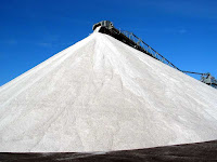
If I was the Mayor of Portland I would order some salt and be ready so spread it BEFORE any snow hits.
Portland Oregon Needs This

Here is the latest high resolution forecasts (and yes, there is still considerable uncertainty in the forecast).

To get snow and freezing rain, one needs cold air.  That is coming, starting tomorrow.  The following are a series of forecast maps from the UW high resolution prediction system, showing sea level pressure (solid lines) and temperature (shading, blue is cold).

4 PM Monday:  mild (green color) air over most of the region.

 4 PM Tuesday, an influx of cold air is occurring in Washington, northern Idaho, and Montana.
 Cold air is in place east of the Cascade crest and a very large difference in pressure have developed across the Cascades.  Strong easterly winds would be occurring in the Columbia Gorge.

 Thursday, 4 PM.  Little change east of the Cascades but warmer air to the west.
So plenty cold for snow east of the Cascades.  Cold air in the Gorge and over the eastern side of Portland. Windy and cold in the Washington Cascades passes.

On Thursday and early Friday an area of precipitation will move northward into the region (see the 24-h precipitation ending 4 AM Friday  For most of the west, this will fall as rain, but in the Gorge and immediately downstream of it,there could be snow and freezing rain.
The 24h snowfall prediction ending 4 AM Friday suggests this...and if anything the model is probably underplaying the cold air coming through the Gorge.  Substantial snow along the eastern slopes of the Oregon Cascades.

It is too early to have too much confidence in this snow forecast, but the cold air east of the Cascades is pretty much a sure thing, as is some frozen precipitation in the Gorge.   Keep tuned and don't hold the salt if you are in Portland.
January 28, 2017

Super High Pressure Hits the Western U.S.

Most of us feel a lot of pressure in our daily lives, but today it is for real:  unusually high pressure has built over the western U.S., with some locations hitting monthly records.    And for those of us living in the Pacific Northwest, the atmospheric pressure we are experiencing now is the highest we have felt in years.

As shown by the  NWS analysis below, a huge area of very high sea level pressure is now parked over the western U.S.  Meteorologists generally talk about sea level pressure (the pressure the atmosphere would have at sea level), because that gets rid of terrain effects.  If we plotted station pressure, the pressure at the elevation of the observing station, altitude differences would dominate.


The more detailed NWS surface map shows that the highest pressures over the Rockies (exceeding 1050 hPa/mb), with values above 1040 hPa over eastern Washington and Oregon.


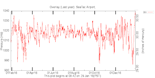
To give you some perspective, average sea level pressure is around 1013 hPa and we rarely get above 1030 hPa in a normal year.     In fact, the pressure being experienced Saturday morning is the highest in over a year in our region.   To show this, here are plots of sea level pressure at Seattle and Spokane, which is now around 1038 and 1043 hPa as I write this blog.

A number of locations in the west have or will exceed their January record sea level pressures.  For example, San Diego and Bakersfield, CA have already beat their January pressure records.

At the periphery of the high pressure area there are regions of large horizontal pressure gradients (or differences in pressure over distance), which has produced some strong winds.  Here is plot of the gusts over 34 mph during the past 24 hours.  In the terrain behind San Diego winds are gusting to 50-80 mph, and strong westerly winds are descending along the eastern slopes of the Rockies and out into the Great Plains.


Closer to home, winds are gusts to 30-60 mph in the western portion of the Columbia Gorge, with the strongest winds at the wind Crown Point viewpoint (see map of Portland area gusts)


High pressure has been substantially influencing the water levels of our region--making them lower than expected.  An  illustration of this is the predicted and observed water levels at Seattle, WA provided by NOAA (see below).  For some


times during the past few days, water level was nearly a foot lower than predicted.   Why is this true?  Localized high pressure actually pushes down the water surface.   If you want to read a very nice account of the impacts of high pressure on Puget Sound, check out Greg Johnson's blog.

Enjoy the pressure and dry conditions today....tomorrow a weak frontal system will bring clouds and light rain during the afternoon and evening.

January 27, 2017

Dry North, Wet South: The Expected Winter Precipitation Anomalies Are Reversed

The forecasts by the NOAA Climate Prediction Center and many modeling centers were fairly unanimous last fall, expecting that this winter would see above normal precipitation over the Northwest and below-normal precipitation over California (see example).


The reason for this prediction was clear--a weak to moderate La Nina would be in place for most of the cool season, which often leads to such a wet north/dry south pattern.

But reality turned out very different.  The upper level flow pattern was dominated by a low-pressure anomaly (difference from normal) over the Pacific Northwest, that drove the jet stream into California and colder, but drier, air into the Northwest (see 500 hPa upper level height anomaly below, the purple area represents much lower than normal heights/pressures).


Lets look at the actual precipitation reaching the ground over the western U.S.  The percentage of average precipitation for the last three months over the region (see below) clearly shows drier than normal conditions over Washington State and northern Oregon, but a way wet situation over California (150% and more!).


 Looking at the actual difference in precipitation from normal (not percent, but inches), some parts of the Sierra Mountains and coastal range of California are more than 20 inches above normal---amazing.   A real drought buster.

 What about the next week?   Over the next few days, a high-amplitude ridge of high pressure will build along the West Coast, drying out the entire region (see below).

 But it won't last!  A weak trough of low pressure will move through the Northwest on Sunday, bringing some light rain, followed by a return to the pesky troughing, which will again result in the jet stream heading into California (see below).


The result, as illustrated by the UW WRF model precipitation totals for the 72 h ending 4 AM Friday, is lots of rain to the south of Washington State. The saga continues.


Finally, this winter's busted long-range forecast is ANOTHER good illustration that my profession has only minimal skill for our seasonal predictions.   Last year did not work out well either.  Clearly, a subject suitable for lots of research.

January 24, 2017

Weather Satellite Imagery Now in Color!

During the late 1960s and early 1970s, many households moved from black and white to color TV.

Meteorologists are about to do the same thing for operational weather satellite imagery, with a new operational geostationary satellite:  NOAA 16 (a.k.a. GOES-R).  

NOAA (the U.S. National Oceanographic and Atmospheric Administration) has two types of weather satellites: geostationary satellites (known as GOES), placed in an orbit at 35,000 km above the equator that allows them to rotate with the earth, and polar orbiters, located around 800 km above the surface, that follows an orbit that views ever-changing swaths of the earth's surface.  Previous GOES satellites provided only black and white imagery, but the latest satellite, launched on Nov. 16, 2016 views the earth in more light wavelengths, thus providing color images.


Let me show some of the first pictures from our new (and very expensive) satellite.  In geostationary orbit, the satellite views the entire planet (see below), with blue oceans and multi-color land. Beautiful.


And here is a closer view of the U.S.


And the West Coast.  Not only are these images in color, but they have about twice the resolution of the old satellite imagery.  At the equator, the satellite can distinguish objects as small as .5 km.

 
 The new GOES satellite will be tested for about 6 months before it is made fully operational.


January 22, 2017

Weather Conference Scares Away Bad Weather

The bad weather gods are running away in terror as thousands of meteorologists descend on Seattle.

From Monday through Thursday, the annual meeting of the American Meteorological Society will take place in Seattle and they will enjoy nearly perfect weather.  Dry and  temperatures reaching the upper 40s F each day.

It is fortunate that the meeting wasn't in San Francisco, Los Angeles, or California...locations that will continue to experience rain, wind, and mountain snows.

The infrared satellite image on Sunday night tells the story (below), with a deep low pressure area (swirling clouds) off of Oregon.  Cold instability showers are circling around into California.  During the next few days the low center will move southward, leaving a ridge of high pressure over our region.  Dry and relatively warm conditions will dominate.


Here is the upper level weather map for Thursday morning.   The ridge is evident, as is the trough of lower pressure over the hapless folks in California.


The precipitation forecast for the next 72hr indicates nothing over most of WA state, but substantial precipitation over northern CA.

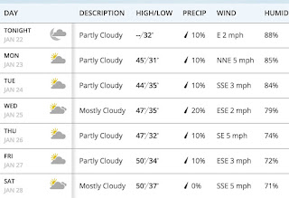
And the forecasts provided by weather.com for Seattle indicate only a slight change of precipitation and temperatures reaching near 50F by the end of the week.  Add this weather to the later sunsets (after 5 PM!), will make it seem springlike in the city.


With warmer temperatures and dry conditions, little new snow is expected in the mountains.  There were a few inches of snow during the past 24h, which helps covers the ice layer produced by freezing rain this week in the lower passes.

January 20, 2017

California's Drought is Over

After a period of intense precipitation, with more on the way, it is clear that California's multi-year drought it over.

Let's begin with the percentage of normal precipitation for the last two months (below).  Nearly the entire state is above normal, with many of the mountain areas receiving 200-400% of normal.
Soil moisture measured by the GRACE satellite?   Above normal (blue colors)!

Streamflow?  Nearly all the state is above normal, with most of it much above normal.
Snowpack in the Sierra?  WAY above normal...nearly 200%

The famous Palmer Drought Index?  Most of the state is well above normal...extremely wet.


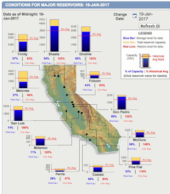
California reservoir levels?   Total reservoir storage is above normal....and remember California has multi-year storage capacity (see below)


Strangely enough, the official U.S. drought monitor (see below) suggests that half of the state is still in drought, with nearly quarter of the area in extreme drought.  Does not seem to fit the observations.


This drought monitor has a history of exaggerating drought or not dropping drought fast enough--so the current situation is not unusual.   A few small reservoirs in southern California are still low (like the Cachuma reservoir that supplies Santa Barbara).   And the water table in the Central Valley has been dropping for decades---but that is mainly from the "mining" of ancient water to irrigate the vast and expanded agriculture of the central valley of CA.

So by any reasonable measure (rainfall, snowpack, soil moisture, reservoir level), the CA drought of the past few years is over.  Furthermore, the latest model forecasts suggest ALL of California is going to be hammered with precipitation during the next three days (see 72h total below), with 3-10 inches along the coast and in the Sierra.


In fact, heavy rain has hit the last dry area of the state:  southern CA, resulting in flooding and mudslides.  The map below shows the amounts over the past 48h--some locations received more than 4 inches.


________________________
Want some free weather fun on Sunday?  Go to the American Meteorological Society WeatherFest (see information here and below)


January 18, 2017

Major Freezing Rain Event Across the Region

Interstate 90 is now closed in both directions and will be closed at least until tomorrow.

Interstate I-84 is now closed both ways in the Gorge.

The reason?  A major regional ice storm in the Cascades Passes, the Columbia Gorge and in portions of the Columbia Basin.   

Freezing rain has resulted in several inches of ice on roadways, trees, and powerlines.  Some pictures  below show the story.  First, several around I-90 provided by the Washington State Department of Transportation.


 Scenes in the Columbia Gorge were equally dramatic (here is one taken by Patrick Oldright outside the Vista House in the Columbia Gorge)


The meteorological set-up was classic.

We started with a layer of subfreezing air east of the Cascade crest and an offshore directed pressure gradient (higher pressure to the east).  This pressure difference pushed cold air into the Cascade passes and through the Columbia Gorge.

Then a warm, wet Pacific frontal system approached, producing an above freezing layer aloft and rain that fell into the cold layer near the surface (see schematic).  Even when cooled below freezing the falling rain (comprised of supercooled water) did not freeze until it hit the ground.

Freezing rain also fell in the Columbia Basin today, as rain fell into the cold air that was trapped in the lower elevations of the Basin.

The Columbia Gorge and Portland are well known for freezing rain, which is sometimes called the "Silver Thaw".   Ditto for the Columbia Basin.
A map of the climatology of freezing rain over the U.S. below shows that eastern WA and the passes to its west experience freezing rain more frequently than any other region in the western U.S. (2-4 events a year on average).  Freezing rain is

even more frequent over the central and NE U.S., but the origin is very different: generally associated with warm fronts, with warm rain above the front  falling into cold air below.

With the atmosphere warming above and the reduction in the offshore flow as the cold air is mixed out to our east, the threat of freezing rain is rapidly diminishing in the passes.

Tomorrow's Windstorm in Four Acts

 Each atmospheric "play" is different and according to high-resolution forecast models, I can describe the four "acts" t...