And it was a convergence zone with serious consequences, leading to dozens of accidents, the closure of I-90, and the death of a woman and her unborn child.
As a reminder, a Puget Sound convergence zone forms when low-level westerly/northwesterly flow on the Washington Coast is forced to move around the Olympics and then convergences over Puget Sound. Such low-level convergence forces upward motion, clouds and precipitation that stretches from the Sound to west side of the Cascades (see figure).

Convergence zones really rev up when two things occur: (1) an unstable atmosphere, in which temperature cools rapidly with height, and (2) an environment with upward lift.
We had both of them last time. The air aloft was very cold....in fact, the air at 5000 ft (850 hPa) was near record levels. This is illustrated by the figure below, which shows the climatology of 850 hPa temperatures at Quillayute, on the WA coast. The blue line shows the record lows for the date and the gray circle was the observed value yesterday at 5 PM. Pretty much tied the record cold for the date at that level!


The visible satellite imagery at 6 PM yesterday showed a classic convergence zone signature. You can see the thin enhanced band over Puget Sound that widens and stretches towards the Cascades. The classic clear areas to the north and south of the band was evident-- due to sinking air in the lee of the Cascades and mountains of Vancouver Island. And percolating, unstable air offshore (you can see the convective clouds). Just perfect.

The convergence zone was very evident in weather radar imagery. Here are some 1-h precipitation totals based on radar data... you can see the band of convergence precipitation over the Sound and the HUGE enhancement on the western slopes of the Cascades.


Some lighting was produced by the relatively deep cumulonimbus associated with the convergence zone. The lightning detection network showed on strike right over Seattle (see below)

You could get a great view of the situation from the Space Needle PanoCam. Looking south, the clear zone was evident.

But turning 180 degrees to the north one was viewing the jaws of deep clouds and heavy rain.

With very cold air aloft (about -6C at 850 hPa....5000 ft), we started with a very low snow level (around 1000 ft). So getting snow in the passes was no problem. Snoqualmie got hit hard, with 16.5 inches of new snow reported. The pass closed last night and was still closed....as spinning out cars and tracks blocked passage.


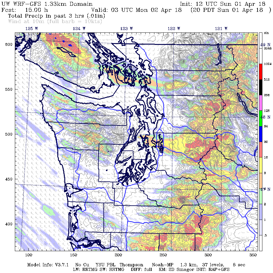
The threat of a convergence zone was clear earlier during the day, as was the low snow level. Here is a forecast of the 3-h precipitation ending 8 PM Sunday, from the UW WRF model run made 5 AM Sunday morning. Not bad.
Seeing this situation, I believe we need to find a way to provide folks with better real-time warnings when this kind of situation occurs, including the use of WSDOT reader boards to slow traffic way down when such features occur. People tend to drive too fast when such inclement weather occurs and WSDOT and my profession need to build an infrastructure that will warn drivers and force them to slow before this hit weather hazards such as heavy rain, loss of visibility, roadway ice, and snow on the roadway. Next week there will be a WSDOT idea session and I will try out some ideas with them.
_________________________________________________________
Announcement: The Northwest Weather Workshop is on April 27-28
The NW Weather Workshop is the big annual meeting for those interested in Northwest meteorology. This year we will have a major session on the meteorology of NW wildfires and others on other aspects of our regional weather. The gathering takes place at the NOAA facility in Seattle. To view the agenda and to register, go to the meeting website. The workshop is open to everyone, but registration is required.


All morning there has bee alternating periods of snow, sleet, hail, heavy rain and sun at Chuckanut Bay (near Bellingham).
ReplyDeleteWhile I would never deny the potential benefits of better forecasting, I am always puzzled by the fact that drivers don't react to what's right in front of their noses.
ReplyDeleteDo we need an alarm klaxon and big red letters on a screen in our car to say, "It's snowing. Might be slippery. Slow down." Presumably, everyone looks out their windshield when they drive. They know what snow or hail on the road looks like. They know how it behaves.
Maybe in the future when cars are fully autonomous, then perhaps a data feed will be required to tell the vehicle to drive differently when weather changes. The accidents today aren't caused by unforecasted weather conditions, they are caused by unskillful drivers who don't adjust to what they can see or get off the road when conditions exceed their personal expertise level.
I have visions of some future state where all the autonomous cars are parked along the side of the highway because conditions are below safety thresholds, and waiting for them to improve. No pushing ahead. No "I've got to get there on time regardless" magical thinking.
Human judgement and automobiles are not a good technology match. When autonomous cars are perfected, I'll be more than happy to see the silly steering wheels and pedals disappear, both of which are left over 1900 model year technologies.
The idea that fully autonomous cars are just around the corner seems like completely unjustified technological optimism to me. And until the autonomous car can recognize snow and other limiting conditions and act accordingly, they will not be ready for the road.
ReplyDeleteAll the warnings in the world will not slow the handful of braindead drivers down.
ReplyDeleteNice summary. One question: what is the mechanism that causes the convergence to move south like it did yesterday?
ReplyDeleteIt thundered too at Bellingham.
ReplyDeleteCould some of these tragic accidents be prevented by extending the studded tire deadline by 2 or 3 weeks?
ReplyDelete