Currently, a far weaker wind event is occurring over northern California--as a result the power utility (PG&E) has shut off power to roughly ten thousand customers, including those near Paradise and Chico, CA.
The sea level pressure pattern this morning (8AM) shows high pressure pushing into the Northwest and southeastward into the intermountain region. This high pressure is associated with cold air (green colors) in the interior. Note the lower pressure and warm air over the CA coastal zone. The result of this pattern is a large pressure gradient over the Sierra Nevada and northern CA that produce strong wind. (Winds accelerate from high to low pressure near terrain).

The maximum observed gusts since midnight (see below, click to enlarge) show winds gusting to 51 mph at Jarbo Gap near Paradise, 54 mph at Mt. Diablo, just east of Oakland, and 46 mph northeast of Santa Rosa. Such wind speeds, although not really exceptional, were similar to those experienced during the destructive Camp Fire of last year. But this time the power is out in vulnerable areas, and hopefully PG&E has made strides to upgrade their poorly maintained system.

But today's minor blow is nothing compared to what will happen on Wednesday and Thursday.
By 5 AM on Wednesday, very cold, dense air, associated with high sea level pressure, will surge into the Pacific Northwest (see below). Yes...that will bring more snow to the Cascades and Rockies.
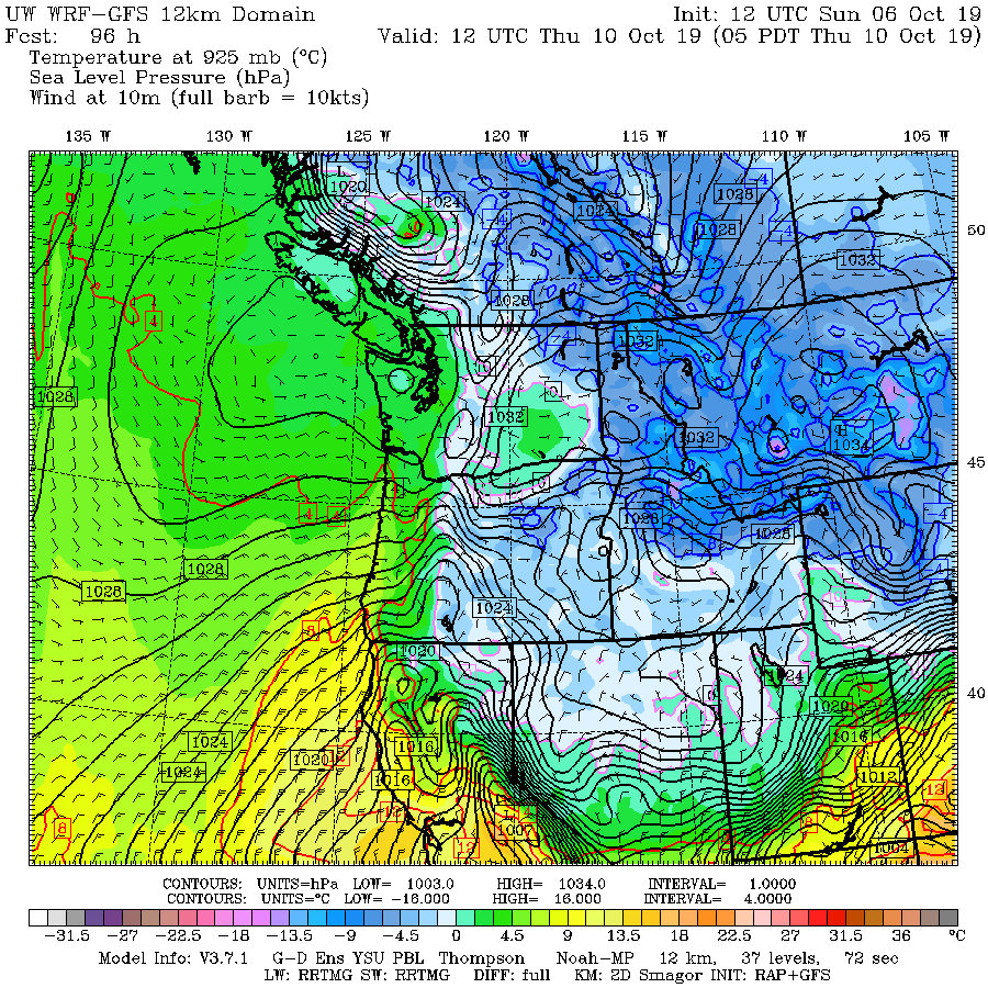
At the leading edge of the cold air, there will be a large pressure difference (gradient) the produces strong winds. The image below for 5 AM shows an intense pressure gradient over northern California. But it will get stronger and move south.

By 5 AM on Thursday, an intense pressure difference will be found over the Sierra Nevada and northern California (see below). This will produce very strong winds over the western slopes of the Sierra Nevada and northern CA, far exceeding what is occurring today. Known as Diablo winds, they are real threat. I might note that I have a National Science Foundation grant to work on these winds and just finished a paper on it with Brandon McClung. This situation is a classic.
The sustained surface wind speed forecast (in knots) for the same time (shown below), indicates strong winds over the western slopes of the Sierra Nevada and over the terrain north of San Francisco. This forecast is from a relatively low resolution simulation (12-km grid spacing). High resolution forecasts will undoubtedly predict higher winds..and remember these are sustained (2-min average) winds. Gusts will be substantially more.

These strong winds will be interacting with vegetation that has tried over the long summer. But quite honestly, even if it rained a few days ago it would not make a big differences for the finer fuels (e.g., grasses). Strong easterly Diablo winds can dry out such fuels within hours.
To illustrate, below is the 10-hr dead fuel moisture at Jarbo Gap on the western slopes of the Sierra Nevada near Chico, CA for the last 90 days. 10-h fuel moisture represents the moisture level in small branches to large grass--the kind of material that has been the key fuels for recent CA fires.
For most of the summer, the moisture % was around 6%--plenty dry to burn. In September, there were two rainy/cool periods and the moisture level jumped to around 25%. But note how quickly it came down...and is now back to roughly 6%. This is true for all of northern CA. The place is ready to burn--all it needs is wind (which will occur) and an ignition source.

There is real fire potential here and the region must be prepared. Prepared to quickly evacuate if necessary and prepared to de-energize the power lines as we get closer to the event.
We have had two catastrophic fires that killed dozens people and cost tens of billions of dollars during the past two years. With excellent meteorological warnings, appropriate actions by the population and civil authorities, and a pro-active response by PG&E, hopefully another tragedy can be avoided.
________________________
My blog on UW College of the Environment Censoring of Social Media is Here.


Cliff
ReplyDeleteIs this the kind weather warnings given thru your blog that UW wants to squash by strong arming you. It was both sicking and discus sting what your department heads have been doing to you and free speech.
Cliff,
ReplyDeleteIt's good to know about your recent paper on the diablo winds. I'm surprised PC&E agreed to shut down power, but I am glad they did. After Paradise, we all know every precaution should be taken.
It must be hard to live in the area at risk knowing the potential for danger. My decision would likely be to leave the area at least during the high risk time period.
Thanks for your good work on this situation.
I hope your warnings are heeded by the authorities in Northern California..do you send them to many jurisdictions and appropriate entities??
ReplyDeleteAre PG&E's shutdowns strictly due to fire fears, or will there also be a crippling loss of wind generation?
ReplyDeleteOverreacting??
ReplyDeletehttps://abc7news.com/society/pg-e-power-shutdown-timeline-when-your-power-could-come-back/5603844/
The current, Wednesday noon, wind forecasts for northern CA are for nothing approaching the dire one presented here. Only for 25 mph the rest of the afternoon in Glenn County. NO strong winds predicted for the SF Bay area. I hope that PGE shows some sense and cuts way back on the promised PSPS.
ReplyDeleteThat’s funny. No wind. I feel bad for the California winegrape industry that have had their harvest hijacked. No power, wineries are shut down, pickdates get canceled, growers can’t water their overripe fruit.
ReplyDelete