I have gotten quite a few emails asking about a strange radar echo off the Washington Coast, including a few claiming a secret military operation and one suggesting an alien presence.
Here is an example, showing the Langley Hill radar on March 15th at 0503 UTC (10:03 PM March 14th PDT). The is one of the lowest scan angles: 0.5 degrees. Radars are tilted at various angles in the vertical and scan around in direction (azimuth).

You see the echo off of Hoquiam? That is what I am talking about...and here is an expanded version

Two hours later...still there. Very strange. A meteorological feature would not do that.

When the radar is scanned at a higher angle (1.3 degrees), the echo goes away. Bizarre!


Pesky aliens again or more secret flights from Whidbey? I wish, it was so exotic.
In reality, the radar beam is hitting the ocean and reflecting/scattering back to the radar antenna.
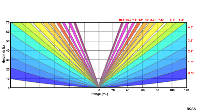
When the radar signal leaves the radar, it moves out as a cone that widens with distance. The Langley Hill radar near Hoquiam and all National Weather Service radar beams have a width of 1 degree, which means most (but not all) of the energy stays in a 1-degree cone. And note that the cone widens away from the radar.

When the Langley radar was installed, all NWS radars but one had their lowest angle at 0.5 degrees above the horizontal. The ONLY radar allowed to go lower was OURS at Langley Hill...and you can thank U.S. Senator Maria Cantwell for that. More recently, a few radars have been allowed to have angles below 0.5 degrees.
So why is the echo offshore of Hoquiam?
Answer: The lowest bean from the Langley Hill radar is hitting the Pacific Ocean and reflecting back to the radar. That is why the echo is stronger fore for the lowest beam and goes away when the bean is elevated.
And there is a fun way to prove this is not a real meteorological target. Langley Hill is a Doppler radar that provides the speed of the echo towards or away from the radar. Below is the Doppler velocities at the same time as the first image above. No velocity towards or away from the radar (light gray color)! Most meteorological targets are moving because of the wind.


I will try to have an open mind about other explanations.


I will try to have an open mind about other explanations.


When I was down at the beach two weeks ago it was great to use the radar to monitor when the squalls were coming in. This allowed my wife and I to time beach walks between the rain. The radar reflections are a bit annoying since it is confusing when looking at the radar.
ReplyDeleteCould you please explain why this one NWS radar is allowed to go below 0.5 degrees above the horizontal and why it required a U.S. Senator to allow it to do so? It sounds like there is an interesting story/rational for it that I would like to understand better. Perhaps a topic for your next podcast? Thank you.
ReplyDeleteCliff wrote a terrific explanation and history of how the Langley Hill radar came to be, and what it can do. See https://atmos.washington.edu/~cliff/Langleyradar.html.
DeleteIf you look at these echoes as well as the ones that just started between Portland and Canada last week on cloudless nights you will notice these are all moving northward. In the fall similar echoes move southward. These are migrating birds. They were holding off, late this year, due to the snows in February. The Great Migration us underway
ReplyDeleteMy intuitive hunch, was that the radar was reflecting off of something very large--like a gigantic collection of surface garbage!...I was on the right track...just not realizing that the ocean itself could cause this.
ReplyDeleteSide note....is there anymore snow coming to the Everett/Arlington area???
ReplyDeleteWhy is this showing now but not at other times?
ReplyDeleteI'm no radar expert, but I'd make the suposition that right now, there's whitecaps/extra choppy water.
DeleteWhen the ocean is smooth, the radar waves just skip along the water like a stone; but when the surface gets rough enough, the surface can start having the effect of a wall, and reflecting the radar _back_ instead of forwards.
Alternatively, there could be fog or extra dense, moist air from extra _still_ air?
All supposition, of course, but fun pondering!
Neat! One presumes that it correlates with the tides as well?
ReplyDeleteIs this the same reason RadarScope always seems to show clumping/fuzz around South Everett? I assume it’s the trio of the Mukilteo Lighthouse, Paine Field tower and the Casino Road water tower... (?) Thank you for the post...
ReplyDeleteLOVED this post, prof! Thanks
ReplyDeleteWhat were corresponding surface winds at the time? I ask because on a choppy day a considerable amount of sea spray is lifted off of the ocean surface and carried quite a distance inland.
ReplyDeleteLangley is not the only radar that can operate below 0.5 degrees. Many radars operate below that. KGJX is operating at -0.221 degrees currently.
ReplyDeleteMike...when Langley (KGLX) was installed it was the only radar that could go below .5 degrees. More recently, some radars have been allowed to do so..cliff
ReplyDelete