Today we are experiencing the unusual: a relatively potent June atmospheric river, in which moisture from the subtropics is heading directly into our region.
Substantial precipitation has fallen, helping to mitigate previously dry conditions from northern California to coastal Brtish Columbia.
The radar image tonight says it all.....rain, some of it moderate to heavy, extending over western Oregon and Washington:
And a recent satellite image of atmospheric water vapor content shows an impressive moisture "river" extending from north of Hawaii to southern Oregon.
Precipitation has been bountiful....and the event is not over by any means. The event-total through 4 PM indicates about a half-inch over Puget Sound but 1-3 inches on the south side of the Olympics and 1-1.5 inches over SW Washington. Very welcome, indeed, after a dry spring along the coast.
But if you really want to be impressed with the precipitation, head to southern Oregon and northern CA, where some locations have enjoyed over three inches (see below). That is serious rain.
Many locations will get around 50% more before this is all over tomorrow morning.
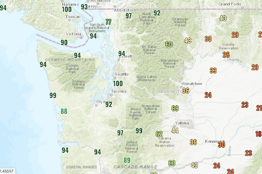
Several of you have emailed me about the humidity. A number of locations in our region have had dew points jump into the lower 60s, which is very high for this time of the year. In fact, we are almost certain to break a few monthly dew point records. With high dew points, our relative humidities have hovered above 90% for the last few hours, including 100% at SeaTac Airport (see 5 PM plot below). But if you want much drier conditions, head to eastern Washington, where values drop into the 20s!
The murk of the saturated air and accompanying fog is evident in a recent KING-5 weather cam (below).
This multi-day event is hardly over, and rain will push over the Cascades and across the eastern slopes of the barrier; the precipitation is very, very welcome since it will put the "damper" on wildfires for a while.
Here is the latest European Center model forecast for the total precipitation over the next 48 hours. Substantial rain over the Cascades and far eastern Washington. Expect some thunderstorms in the mix during the next few days---more on that in my next blog.


Any way to predict how dry the summer will be? Getting mixed messages about the fire hazard and more specifically, the smoke hazard.
ReplyDeleteYou could always have a diligence attack and read his post from a few days ago, helpfully titled, "Wildfire Outlook for the Pacific Northwest." LOL
DeleteWe've had an inch and a half in the Columbia Gorge, which a lot for here, especially now. Cliff, can you just imagine how disappointed they are at the Seattle Times and the (some of) the public radio stations? LOL
DeleteEllensburg just got hit, but it only lasted a half hour
ReplyDeleteThank you Mr. Mass for the explanation of Atmospheric River. Looking forward to your next episode.
ReplyDeleteLooking forward to possible thunderstorms.
ReplyDeleteAfter reporting my morning 24-hr precip data to CoCoRaHS (.43" in Glacier), I checked morning email and saw Seattle-Times' headline and blurb about lack of rain and drought: "Washington heads into wildfire season with a drought and record number of early fires. Residents across the state these past several years have become intimate with one or another hellish manifestation of wildfire season: blankets of smoke muddying the air; swaths of forest and grasslands scorched; homes, businesses and towns burned to the ground; lives lost. Even the rainforests have caught fire. Here's how the state plans to prevent and combat wildfires this season." Wowee! "Even the rainforests have caught fire."
ReplyDeleteSo, I took a look at the interactive map of "dailies" that others have posted and gee-whiz, 3.43" rain was reported at Brookings OR, and most of the banana belt zones got a good soaking. The current UW radar and satellite images indicate this front is still moving through but nearly done for the moment.
I just compared dailies and YTD data for the last few years, and (at least here) for this time of year we're still well within "range of normal." In the last four years, comparing the first few weeks of June (specifically, June 5's to June 14's) it seems we've had very similar early-June rainy spells: 2018 (6 of ten days), 2019 (5 of ten days), 2020 (9 of ten days), 2021 (10 of ten days) - here. I'd like to mow but there have been too many showers to keep up.
We live on the WA side of the Columbia Gorge. Early spring was dry and cold, and with the exception of a brief hot spell a little while ago, it's been a cool spring. We have two large gardens (among other things, 90-100 lbs of tomatoes last year), and the slow plant growth shows it. I just recently turned off the irrigation system because the soil is soaked.
DeleteWe've also noticed MUCH less wind here. Wind is probably the most defining feature of the climate here, so the change relative to the past few years has been quite striking. I was ready to install wind breaks to protect parts of the gardens, but I will shove it off until next year.
I raise another toast to Cliff Mass! Not because there will likely be no drought or serious fires, but for his level-headed analysis and scientific approach at a time when the media are intent on pushing a political agenda that departs from history and current factual reality. Cliff is a public asset, and even though I don't agree with him on global warming, I have boatloads of respect for his scholarship, his integrity, and his courage under so many vicious attacks by Seattle's ignorant, arrogant, thoroughly dishonest, feckless, destructive, and unprincipled "progressive" overlords.
Watched the weather Channel dropped the chance of thunderstorms for Tuesday now, is that still possible tomorrow? Great podcast as always!!
ReplyDelete