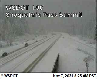
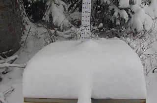
As predicted, the cold, unstable air streaming into our region has dropped substantial snow in the mountains.
Even at low levels (~3000 ft), Snoqualmie Pass received enough to cover the roadway.

Our temperatures have been running much below normal the past few days, with today only getting to around 45 F today. These are mid-winter temps.
The latest regional high-resolution model run is in, predicting as much as 1 foot by Wednesday morning in the North Cascades and even more over the BC mountains (see accumulated snow graphic below). A very good base to build upon for this season.
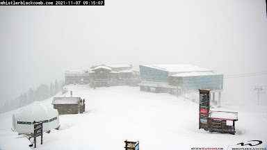
Whistler is planning on opening on November 25th and the latest webcam suggests they could be open for business today:
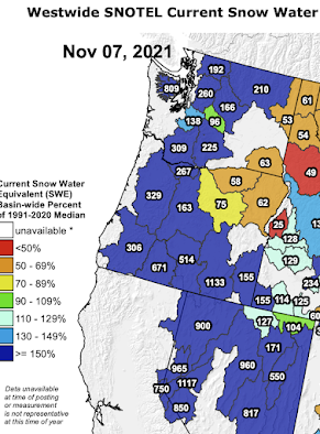
And even before this snow dump, our snowpack this morning is well above normal, something shown by the SNOTEL network (see below). Much of the west is above 150% of normal, with the Olympics at over 800%!, , but keep in mind that so early in the season small amounts of snow can produce big percentage changes.
_____________________________
Announcement:
I will be doing a book signing and dinner event at Ivar's Salmon House in Seattle on Wednesday, November 17th (6 PM). You can come just to purchase a book and get it personalized or you can stay for a special dinner, where I will be giving a weather talk. More information on the event is found here. You need to make reservations for the dinner (only 80 spaces available). And information about the new edition of my book is here.
.png)


Even though the windstorm now looks to be just breezy conditions, I'm not totally leafless. The trees on the side of my yard between the sidewalk and street have been leafless for a few days, the tree out front in the past couple of days just lost its last few stragglers and none are big trees at that anyway.
ReplyDeleteA major storm of that magnitude fizzling out is disappointing, but the rain, well, it's been WET in Tacoma that's for certain.
It's still too early for accumulating snow,except at the highest elevations.The upcoming atmospheric river later this week will wipe out most of the past few days snow.
ReplyDeleteI was thinking the same thing John. I was out hiking today and above 4400ft there was a good ~2ft of snow but by next weekend snow level moves to 9k which could potentially wipe out this snow.
ReplyDeleteCliff, what are your thoughts on this? We usually have several atmospheric river events before the temperatures lower enough to keep snow levels low. I will say that I saw more snow today than I've seen the a decade of hiking in the cascades for this time of year. Tons of moisture tho in this last system and a solid forecast Cliff.
No coverage of the UBC tornado?
ReplyDeleteHas the storm fizzled or just the track moved further north and not directly affecting US lower 48? I note both the ECMWF and GFS models showing 'bomb' development for the +- 965 to 962 low by midnight tonight. The forecast 10 m for just off Cape Flattery and up in Haida Gwaii/Hecate Strait/Alaska panhandle is gale to storm force and gusts are into hurricane force, so is fizzle appropriate, or are you seeing something that will lessen that, or literally NIMBY ;) ?
ReplyDeleteSolander Island just off NW Vancouver Island had sustained hurricane force winds for hours with gusts to 87 knots https://weather.gc.ca/marine/forecast_e.html?mapID=02&siteID=15300. Solander often has the highest windspeeds with compression from the Brooks Peninsula and looks like something out of a Lord of the Rings movie, dark and foreboding even on a sunny day. I just had an interesting ride into my office in Victoria going around the many branches down overnight.
DeleteCliff: I (and perhaps others) would be interested if you addressed the following related question.
ReplyDeleteOfficial world records for annual snowfall have, of course, been set at Mount Baker and Mount Rainier. But a week ago, a forecast was made for mountain snowfall north of Anchorage on the order of 27 FEET in three days! However the exact amounts could not be measured, because spots that are measured in snowy mountains are rare.
So where and how much is the REAL world record for snowfall in one year? Maybe AK, maybe BC, maybe at the top of Rainier, or high on some mountain in Aomori in Japan? Or somewhere else?
And a related question: does the snowfall continue to increase as you ascend Mount Rainier, say? Or is there some point above which it begins to decrease? (I mean, not in a particular storm, but annually?)
If you find them interesting, perhaps you can address these questions in a post some time. I have often wondered. Thanks.
I’m in Anacortes and I’m not sure the windstorm has actually fizzled out. This morning is the most wind we have had so far. Not sure how big these gust are but I wouldn’t consider it “breezy” here.
ReplyDeleteVery windy in west Seattle too.
ReplyDeleteJust saw a 58.2mph wind gust recorded on a Magnolia weather station, the highest recorded all year. This one is no sleeper.
ReplyDeleteThe important question is whether all of Bachelor will be open to skiing over Christmas break. The AirBnB reservation has been made.
ReplyDeleteIn other news, yet another reason why so many citizens distrust the scientific community at large these days -
ReplyDeletehttps://www.nature.com/articles/d41586-021-03035-y
People posting academic gibberish get their papers published, even after allegedly having them peer reviewed. You can't make this stuff up.
I lost power for 20 minutes yesterday. The wind is still doing its thing even if it is not as strong
ReplyDelete