Last weekend there were highly damaging floods over Northwest Washington, with the town of Sumas and its vicinity being inundated by floodwaters. Several landslides occurred, including some that closed I5 near Bellingham.
Town of Sumas, 2021, WSDOT Photo
Within hours of this heavy rainfall event, politicians and the media were suggesting that this event was somehow unique and the result of global warming.
For example, Governor Inslee called the flooding an example of “a permanent state of attack by the forces of climate change.” The New York Times claimed that flooding in Northwest Washington was caused by climate change (see below)
Similar claims were found in the Washington Post and the Guardian. And, of course, the Seattle Times had several stories, supported by a slew of "experts" (such as a Simon Fraser Professor) stating that climate change contributed to the flooding. The truth is very different than these claims. The Sumas area is extraordinarily prone to flooding and has experienced flooding many times before. And as I will demonstrate below, there is no evidence whatsoever that global warming caused the heavy rainfall associated with this event.
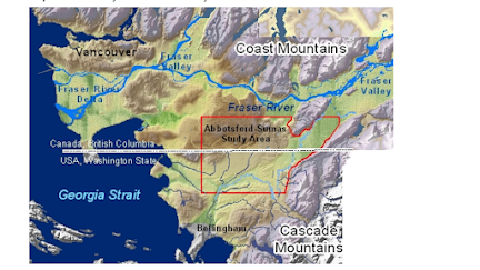
A Flood-Prone Region
The town of Sumas is within the historical flood plain of the Fraser River, with an additional flooding threat from local rivers such as the Nooksack (see maps below from a 2005 report by Dr. Jacek Scibek and Dr. Diana Allen of Simon Fraser University)
Importantly there was a large historic lake near Sumas and Abbotsford (Sumas Lake) that was drained for use in agriculture. In short, a low-lying, historically wet area that has always been prone to flooding.
Previous Flooding
Flooding is not a new visitor to the Sumas area, which has experienced flooding many times during the past century. The streets of Sumas was similarly flooded in February 2020 (see below)
And there were many previous major floods, including those in 1990 and 1951, to name only a few (see some more examples from the Whatcom County analysis of flooding events). You build a town in a historical river delta in one of the wettest portions of North American, you can expect trouble.
To say that flooding in Sumas or the region is something new, unprecedented, or unique is simply not correct. Those making such claims should have spent a little time examining historical floods of the region..
Global Warming And Heavy Precipitation
There has been a LOT of handwaving about the heavy precipitation during this event, claiming it was the result of global warming. Or that it was greatly enhanced by global warming.
Yes, we had a major rainfall event, but to make a claim that global warming was the origin, it is necessary to demonstrate that there has been a progressive increase in heavy rain, something that would be a sign of a global warming origin.
Let's look at the data. Karin Bumbaco, Associate Washington State Climatologist, graciously provided me with plots of annual maximum 24-h rainfall at Bellingham, WA, and at the nearby Clearbrook official climatological observing site, with the latter having a very long record (see below).
There is NO HINT of a trend towards more extreme precipitation at either of these sites. According to Karin, the big peak in the mid-1930s was from an error in putting two days of rainfall into one day.
Such a lack of evidence of global warming is consistent with state-of-science regional climate modeling, which found that climate models (driven by very aggressive increases in greenhouse gas emissions (RCP8.5) did not produce significant increases in 24-h maximum precipitation in the area over the past half-century (results for Bellingham is shown below). By the END of the century (not shown here), aggressive global warming will increase the heaviest precipitation...but that is in the future.
But wait! There is even more evidence against a global warming contribution to this localized heavy precipitation event.
The origin of this event was a moderate atmospheric river, in which a narrow plume of water vapor was forced upward by our local mountains (see plot of water vapor at 4 PM last Sunday).
If global warming was important, then one would look for above-normal sea surface temperatures along the atmospheric river's path, which would provide additional moisture to the air.
Below are the sea surface temperature anomalies (differences from normal) for the period leading up and including the atmospheric river in question. It was cooler than normal immediately off our coast and near normal for virtually the entire path of the atmospheric river. With La Nina conditions, the water temperatures near the equator were BELOW normal. No sign of a global warming contribution.
Forest Fires Did Not Contribute to the Flooding
In desperation, some of the global warming advocates are suggesting, without a shred of evidence, that the forest fires from last summer were contributing to the flooding. Specifically, they claim that debris from the fires and less absorptive capacity of the burned landscapes resulted in more water and material entering the rivers.
We can see how much of the land immediately around the flooding areas was burnt using NASA MODIS imagery (see below for October 31st, when it was clear). Recently burned landscapes have a reddish hue (I have indicated an example of a recent fire, east of the Cascade crest, with a red arrow.
It is obvious that there are no major burnt areas around the flooding area or the associated river basins that received heavy precipitation during this event. So wildfire burnt areas did not make a contribution to these fires.
Snowpack
Another claim, as found in the New York Times, was that there was low snowpack (due to global warming) before the flood, leading to a reduced capacity to soak up the rainwater. But that was not true: the snowpack was well above normal prior to the event (USDA Snotel map a few days before the flood is shown below). The snowpack was well above normal.....not exactly the kind of situation associated with global warming. I mean MUCH above normal.
I should note that melting snow probably had little impact on this flooding event. There are several papers (such as
this one) that documents that rain on snow melting is very small compared to the rainfall itself. Furthermore, there was little low-elevation snow before this event, which would be the most likely to contribute.
Epilogue
It is both concerning and problematic that some local politicians, local and national media, and even some scientists are willing to stretch the truth about the origins of this serious flooding event, suggesting a major contribution from global warming (frequently called "climate change".
Society can not effectively deal with environmental threats when it is provided with hyped or false information. And providing such false information, even in the hope of motivating people to "do the right thing", has substantial ethical problems.


Unrelated, but what are your thoughts on WeatherBell? Are there any other good sites for the Euro model?
ReplyDeleteThanks for this good overview Professor. Also I liked your quip about expecting trouble when you build a town in a river delta - so true and every year we see the misery and loss repeated over and over again all over the world.
ReplyDeleteThe NASA MODIS map is not up to date, it only shows up to June this year and doesn't show the burned area from the July fire that burned above the Coquihalla nor the tens of thousands of hectares of burned land in Monte lake, Kamloops or Vernon
ReplyDeleteYou are mistaken. The NASA MODIS image is recent (Oct. 31 of this year) and fires that burned away from the drainages influencing Sumas are not relevant. For example, do you know how far Vernon is from Sumas?
DeleteYou are right about Sumas, but the commenter raises a question that was also in my mind. Did the BC fires play a role in the Fraser watershed problems in the recent storm. Seems likely they did. Different watershed, same storm.
Delete"seems likely they did." Another unbiased opinion based on rigorous scientific data - nice job!
DeleteTrees absorb water and obstruct flow. This mitigates flooding. I suppose you could quantify the mitigating effect by studying the mass and distribution of trees before and after the fires. However, the two main drivers of the flood are ground saturation (above average precipitation in the weeks preceding the flood) and rate of rainfall (the atmospheric river). Had the trees not burned, would their mitigating effect have been significant?
DeleteCliff, I think you are missing the OP's point. The reference to the other drainages was meant, I think, to illustrate that other burnt areas were not reflected by the map, not that those other areas were somehow contributing to the flooding in Sumas.
DeletePlease excuse my lack of recent geography experience (oh gee, I bicycled through Vernon in 1974, I remember Kelowna), but that MODIS imagery gets nowhere close to Kamloops or Vernon. They're not only "east of the Cascade crest" but east of the east side of the Cascades.
DeleteAlways the voice of reason - and fact! We did have plenty of rain here near Mt. Baker, but we're on high ground and the Nooksack didn't top its banks up here. I meant to check tide tables to see if high tides made it hard for the lowlands to drain. Darn, I didn't get to it (and I'm not nautical, I'd have to do some serious searching to even find the things at this time (after the fact)) - but I expect that tides had some bearing on outfall to the sea. Worth exploring?
ReplyDeleteWould a warm atmospheric river event increase freezing levels and cause snow melt, so it is a combo snow melt rainfall event?
ReplyDeleteThere is a substantial literature showing the rain on snow and subsequent melting is not a major contributor to flooding.
DeleteHere is one paper (https://agupubs.onlinelibrary.wiley.com/doi/10.1029/2019WR024950).
Furthermore, there was not much snow at low levels where melting would have been largest.
I agree about fires not affecting the Sums Prairie flooding. However heavy rain from the same storm on burns scars did cause what I expect to be the biggest economic impact of the significant damage and closure of Highway 1. The is Canada's main(only?) E/W Highway and a significant commercial impact. I'd imagine the economic toll and transportation difficulties from this outweighs the Abbotsford area cleanup. That said I am not an economist, highway expert or involved with flood mitigation.
ReplyDeleteIf there should be any messaging regarding this Atmospheric River event is that it is a good preview of what we should plan and prepare for. "The implication is that society will need to prepare for a substantially more intense precipitation environment by the end of the century" (Warner and Mass, 2017). I did read several articles with statements along that line.
ReplyDeleteRegarding the flooding in Sumas, you are correct that Sumas is flood prone. It does make for good pictures when it floods and hence in the news. A slight correction - The town of Sumas is not in the historical flood plain of the Fraser River. A very large ice age river flowed out of the Sumas valley during the late ice age glacial period into what is now the Nooksack River valley. One could call this river an ice age Fraser River. The low area of the Sumas valley north of the border is a depression left by glacial ice; at its lowest point it is about 11 feet above sea level. It was a lake up to the 1920s, but is now kept usually drained by pumps that pump the water out of the low part of the Sumas valley to to the Fraser. The Fraser never historically flowed into the area where the town of Sumas is located, but may have spilled into Sumas Lake during big floods on the Fraser; however, the big Fraser floods are not in the winter. The Nooksack River apparently flowed entirely into Sumas Lake up until a few hundred years ago versus its current route to Bellingham Bay (Pittman and others, 2003). The bad flooding in Sumas is typically the result of the Nooksack flooding just upstream of Everson with the flood water flow splitting with some heading towards Sumas and the pumps in Canada and the rest heading the usual path to Bellingham Bay. Another tributary, the Vedder River also flows into the Sumas Valley but is now routed by an elevated canal across the Valley to the Fraser in order to keep the lake from reforming.
The articles I read about wildfire and debris flows typically were referencing an area in the Fraser Canyon of BC that did burn severely last summer right after the intense heat wave.
I did not see the NY Times article, but would note that some of the bigger floods associated with AR events can be greatly enhanced from rapidly melting snow. A heavy early season snow accumulation with fairly low snow levels just prior to the AR event will add to the result.
Curious about your take on the paper by Baek and Lora (2021)? They suggest there was little to no change in mean AR characteristics in 1920–2005 due to opposite but equal influences from industrial aerosols, which weaken ARs, and greenhouse gases (GHGs), which strengthen them. The implication, if they are correct, is that AR events will increase sooner than later as green house gas influences outpace the damping of aerosols.
There is a substantial literature showing the rain on snow and subsequent melting is not a major contributor to flooding.
DeleteHere is one paper (https://agupubs.onlinelibrary.wiley.com/doi/10.1029/2019WR024950).
Furthermore, there was not much snow at low levels where melting would have been largest.
The snow line was low prior to the AR and the AR caused melting even at high elevations - I recall the forecast was for snow levels to be at 10,000 feet. The paper you reference is a broad evaluation, but still notes contribution from snow with a fair emphasis not on the rain on snow but other melting factors prevalent in different regions. Studies following the Oriville dam spillway issue associated with an AR and snow melt contrubtion suggest snow melt cpntribution was significant.
DeletePreparation should take the form of adaptation, not attempting to control the weather through control of atmospheric gases.
DeleteThank you Dan for your comment on ARs and greenhouse gases. I did not know about this but I found an informative short article online for an explanation. Others may want to look it up.
Delete"Atmospheric rivers are stable for now — but change is on the way,"
https://news.yale.edu/2021/10/04/atmospheric-rivers-are-stable-now-change-way.
Cliff - Wouldn't an alternate interpretation of that last point be that the above normal snowpack (and the resulting melt-off) was a major contributor. Climate change will cause many things to be different - including the potential for above average snowpacks in November?
ReplyDeleteSteve....no, that is not a valid interpretation. There is a substantial literature showing the rain on snow and subsequent melting is not a major contributor to flooding.
DeleteHere is one paper (https://agupubs.onlinelibrary.wiley.com/doi/10.1029/2019WR024950).
Furthermore, there was not much snow at low levels where melting would have been largest.
The last sentence above shows your assumption that only very local snowmelt matters. That simply wasn't the situation. The freezing level went very high and the rain caused rapid snowmelt up to/near the crest in the entire basin, including higher elevations where there was several feet of snow.
DeleteHere's the gauge at Glacier, Wa : https://natwebsdww02.cr.usgs.gov/nwisweb/data/img/USGS.12205000.151489.00060..20211107.20211122.log.0..gif
Mt. Baker ski area reported "there are sections of snow at the base areas that are fairly deep - 14-20 inches - but all the creeks and runoff zones completely melted out. "
Based on the abstract, the study quantifies runoff due to snowmelt in rain-on-snow events. It does not appear to consider snowmelt contribution to ground saturation prior to the rain-on-snow event... which would require much more detailed modeling of each basin and each event. The finding serves as a useful heuristic but shouldn't be misapplied...
DeleteWouldn't one have to consider the change in groundwater capacity due to snowmelt and precipitation preceding the event to understand to what degree the above normal snowpack contributed? Of course the area would have flooded due to the rainfall alone but to what degree the snowpack contributing to saturation preceding the event or, counter-intuitively, may have mitigated rainfall propagation during the event is not known.
The groundwater capacity is immaterial for this situation. It was a wet fall and the ground is saturated.
Deleteunknown.. snowmelt was not a major driver of this event...it was heavy rainfall. You are making unsupported assumptions. Just because the freezing level was high does not mean high elevation snowmelt has a large impact on low-level flooding. The literature shows otherwise.
DeleteThe November 15 SWE loss at Easy Pass (5270 feet) was 2.7.
DeleteThe November 15 SWE loss at Middle Fork Nooksack (4470 feet) was 2.4 on November 15. Rainfall that day at MFN was 4.9 inches.
This suggests a fairly decent contribution to the run off from snow melt in the Nooksack basin.
The Nooksack is a steep relatively short river basin so flood waters reach the low lands fairly rapidly.
Note the rain also can be stored in the snow so the loss of SWE measurement means that not the only the snow melt but also any rain onto the snow flowed off the snow pillow (a confounding problem in assessing ROS).
The Wayand and others (2015) https://agupubs.onlinelibrary.wiley.com/doi/10.1002/2014WR016576
Estimated that for the Snoqualmie River snow melt contributed 29% to the flood they evaluated.
Wayland and others (2015) also note "These results indicate that for watershed managers, flood forecasting efforts should prioritize rainfall prediction first, but cannot neglect snowmelt contributions in some cases. Efforts to reduce the uncertainty in the above snowmelt simulations should focus on improving the meteorological forcing data (especially air temperature and wind speed) in complex terrain.
Cliff is correct that rain is the typically the dominant driver, but it would be unacceptable to manage and plan for flooding without consideration of snow melt from ROS (and the accompanying wind and high temperatures) as a potential significant contributor to river levels (or all those creeks - in my work experience ROS on low elevation streams is a huge deal). My very preliminary glance at the snow stations in the Nooksack suggests that the snow melt contribution was not insignificant. Anecdotal, but also supported by the lower elevation snow stations, there was a lot of relatively low elevation snow in the Northwest Cascades the day before the AR arrived.
I agree snowmelt is not a major driver. I was just pointing out the mechanics: in some circumstances the snowpack can slow water transport during the rain event and in other circumstances consistent snowmelt before an event can contribute to saturation effecting both capacity and transport during the event. The study you link suggests this rarely matters if ever. But couldn't one construct a hypothetical scenario where it does matter?
DeleteDan... Easy Pass was on the wrong (eastern) side of the Cascades. At Middle Fork Nooksack for the event as a whole, there was about a ten inches gain in precipitation with a 1.6 inch loss of SWE. Precipitation dwarfed SWE loss...and this is a relatively low elevation station. Yes, snowpack melt contributed, but it was a minor player. In any case, this all has little projection on to the central question of the role of global warming...cliff
DeleteEasy Pass Site: 48 52' 0" Longitude: 121 25' 59" Not on the east side of the crest and well west of the crest.
DeleteThe 10 inches of precip at the Middle Fork was over 4 days and started as snow. SWE increased from 2.9 on the 13th to 3.7 on the 14th. The AR warm air arrived on between the 14th and 15th and the change over from snow to rain took place between the 14th and 15th with 5 inches of rain and a loss of SWE 2.4 inches. Between the 15th and 16th 3.5 more inches of precipitation took place but there was no loss in SWE.
Middle Fork and Easy Pass are the two highest stations in the area.
I did not claim snow melt was a major contributor - just that it can be additive. That additive amount will vary for lots of reasons.
As for the "central question of the role of global warming", ARs are a subject I know you have modeled and published on. I agree that no one should point to Sumas flooding as an example of global warming. I am more interested in the near record flood crest on the Skagit and how the ACOE managed the Baker River dams and Skagit dams during the event.
You are right about the position of Easy Pass....over the event there was a total loss of 1.1 inch of SWE...pretty small. At Middle Fork, the precipitation was clearly the dominant contributor, compared to snowmelt. And at lower elevations there was, of course, less snow to melt. The basic point is that snowmelt is generally a relatively small player in such flooding events--a contributor, of course.
DeleteClimate change is the last refuge of the fascist scoundrel. The climate models are crap. They are not validated: they can't match the historical record and show overheating. If Boeing's flight models were that inaccurate, we'd be seeing planes falling out of the sky on a daily basis. I did flight models, those models take two years to validate from flight test data.
ReplyDeleteWe've had 50 years of climate disaster predictions, none ever came true. Two predicted the end of snow in Britain and the disappearance of glaciers in Glacier National Park in 2020. Didn't happen. Another predicted Siberian weather in Britain in 2020. Didn't happen.
Reading your explanation of this event, I accept your conclusions completely. My concern is how the title is worded as well as a lack of information concerning what climate change is responsible for in our region. What I've seen in the comments is many people reacting to the title and using it as justification for climate change denial. Moreover, I don't see much engagement with people commenting here or on Facebook who are making false claims - which you could address from a much better understanding of the science than I could. I agree that the politicization of climate change is a problem from both over-hyping as well as denial. My humble suggestion would be to combat misinformation from both political sides. I may have not seen it, but most of the things I've read from you appear to focus on denying climate impacts for specific events - which is necessary, but I think we could make some more significant impacts by addressing all misinformation. Sorry if I missed the posts addressing climate change deniers.
ReplyDeleteMatt.... there is an army of folks criticizing skeptics (I had the word denier, which takes on a Holocaust terminology). But there are too few folks dealing with the exaggeration of politicians and the media. And what "denier" are you concerned with? Which local media outlet or politician are you referring to?
DeleteThat kind of smear is among the worst the enviros have ever come up with - vile beyond belief.
DeletePeople who do not accept climate change is happening are not skeptics, there is no reasonable alternative explanation to antropogenic climate change. Therefore, they must be considered deniers - whether or not that makes people uncomfortable. The people I'm referring to, as I mentioned, are all the people commenting outright denial of human caused climate change both here and on Facebook in the comments. We also have no shortage of politicians or media personalities who do the same. I hear them more often out here in Eastern Washington than I do on the west side, probably due to political reasons. There is no harm in including what climate change is responsible for in your posts, which would help resolve the issue if you don't have the time or desire to do so in the comments.
DeleteCould the Fraser river fill it's delta and change course to spill out along the Nooksack course? Or maybe if the Nooksack is at a higher elevation as it comes out of the mountains, it would have naturally recharted to the Fraser through the Sumas lake.
ReplyDeleteBecause it's Jay Inslee, that's why.
ReplyDeleteFunny you bring this all up. Yesterday, and I forget the source I was reading now, but it was suggested on my phone and I want to say it through Accuweather (yeah, riiighhht) but the article talked much of what you brought up here in this post from yesterday and I smelled BS as the author seemed to be looking for where to place blame and pointed to the fires from last summer, which was nothing compared to the fires of 2020 that ravaged almost the entire west coast, including BC.
ReplyDeleteThis year, the vast majority was either northern California, or in BC, and did read over the weekend some of what is causing some supply issues in Canada, one being the mudslides over highway 1, and other issues causing ports in BC (one of a very few in Canada that I know of) to back up.
Anyway, it did say to effect that global warming etc was to blame for the floods.
Well, growing up in this area, Tacoma/University Place area specifically, I remembers for years always seeing footage of raging rivers during a storm, or people forming dam brigades to reduce the damage of the flooding to towns near rivers, like Sumas, and clips of homes, rural homes at that, built along rivers being washed away in the raging waters whenever we have had major rains, with a good many of them in counties like Whatcom, the Skagit and the northern areas of Snohomish especially flooding.
I recall one major event, 1990, a huge Pineapple express storm flooded much of the area up that way, including Fir Island and many livestock were stranded in the flood waters, then it all began to recede after the storm, only to have it all freeze over as a major cold front from the Frazer Valley blew in and the flood waters that remained froze over, and all that livestock perished in the ice that formed, leaving the Puget sound area in a deep freeze, once the snow stopped falling for 2-3 days. I remember that all too well as one day my Dad and I went to rescue a sister and her 2 kids from her first marriage from an uninsulated cabin on Bainbridge Island, and the drive north was risky due to the snow on the ground (Hwy 16} and many a car stranded along the way, but we made it. I think it took us over 2 hours to reach the Agate Pass bridge if memory serves, then had to navigate to where she was staying that winter (cabin had no insulation and fully electric, but the power was out), and all the fallen trees and branches and of course, downed power lines.
Needless to say, we got 'em and got back safely. :-)
I've probably said this before, but I think all this global warming is twofold in that it's both the earth's natural variability being closer or further to the sun etc, and our man made pollution stemming from the industrial age, on only exacerbating the situation.
Thank you for writing this post, Cliff. Predictably, the recent floods were blamed on climate change and every flood is the "worst flood yet." It's a floodplain! The ground was saturated before a significant rain event. We've observed these events with some regularity over the past 100 years. Further, the hydrologic cycle in geologic timescales resulted in a floodplain! Clearly, this has been happening for quite some time.
ReplyDeleteIt's hard to imagine a debate about flooding in a floodplain and its mutual exclusion with anthropogenic climate change but I'm certain this debate has taken place. I'm curious what you are seeing in the academic setting: Has political bias compromised scientific objectivity with increased regularity?
I hope you're ready for the continuing stream of these kinds of screeching headlines over the next few months Cliff, if the long - range forecasts are any indication. It appears that another large plume of moisture will be coming to the PNW by the beginning of December, if the forecasts turn out to be correct.
ReplyDeleteThis comment has been removed by a blog administrator.
ReplyDeleteThanks for having integrity. Sorely lacking in the press and politics today.
ReplyDeleteAre you not familiar with Jay Inslee?
ReplyDeleteJust because politicians tell us lies, doesn't mean for a second that we believe them. Any right thinking person knows it's political spin. But thanks for reiterating the facts, Cliff
ReplyDeleteThe reference to RCP8.5 and the END of the century is unclear to me. I think there are at least 7 Representative Concentration Pathways (RCPs) with 8.5 being extreme, although it is often called “business as usual.”
ReplyDeleteInsofar as those things on which it is based have and are changing, and that it was extreme when first articulated, it is not a useful scenario. RCP6 seems possible, but also somewhat high.
As always, I appreciate Dr. Mass' thoughtful and thorough presentation of the data. After demonstrating time and again that the effects of Climate Change are frequently mis-categorized by those with loud voices, I'd be interested in hearing an insider's take on why this continues to occur. In particular, why do your fellow scientists not take a stronger stand in defense of the data? Not asking you to name names, but perhaps a future blog exploring why some of your peers disagree with your conclusions. Do they feel that any ralling cry that might result in action against Climate Change is in the best interest of society? Or are they misreading the science? Or somthing else? Will look forward to your comments in a future blog.
ReplyDeleteCheval, the scientific community in many cases has been corrupted by in - kind PAC donations from those seeking to advance their own personal and political agendas, which have nothing to do in the way of any actual science, but instead are simply other ways to line their own pockets. The graft involved and opportunities to enrich themselves has proven to be too immense for some to resist. People like Dr. Mass have no connections to PAC's or enviro NGO's, so he's been branded as a heretic and therefore must be destroyed at all costs.
DeleteSome peer reviewed science is saying that Climate Change did have a role in last summer's Heat Dome. Cliff said it wasn't due to this in a blog post last summer. See https://www.worldweatherattribution.org/western-north-american-extreme-heat-virtually-impossible-without-human-caused-climate-change/
ReplyDeleteKenna...you evidently did not read my blog. I said that global warming made a small contribution to the heat last summer, but was not the essential cause. And that the attribution report is very poor for explicit reasons I noted in my blog. It was non peer reviewed advocacy.
DeleteCan you show us a graph of "atmospheric river events" for the region since 1970? I am not specifically looking for Bellingham, Seattle, Vancouver, or Portland. I would be curious to see a graph showing the "atmospheric river events" from Portland to Vancouver since 1970. I would like to see the frequency, because in my opinion, the "atmospheric river events have definitely increased in the last 15 years over the region to a frequency that was not as common as before. Thank you.
ReplyDeletePart One of a Two-Part Comment:
ReplyDeleteCliff Mass said in an earlier article posted on this blog concerning weather whiplash: "I am involved in regional climate simulations, using an ensemble of high-resolution projections driven by an ensemble of many global climate models. This is the gold standard for such work."
In the nuclear industry, the software and the data used to directly support a technical decision which will be undergoing a safety analysis review by an independent authority such as the NRC must be developed and managed under strict quality assurance guidelines.
For a process simulation model in the nuclear world, the model's software code -- plus the data the model acquires, creates internally, or produces as outputs -- are all considered essential components of a single unitary system. It's all One Thing.
For any single model run which is being cited in a nuclear safety analysis, a snapshot of the entire modeling system which produced that run must be frozen in time and a copy of it placed into a historical archive as 'record material' which can be examined later by an auditor.
If an ensemble of model runs is being cited, every individual model run in the ensemble must be archived in a way which allows it to be individually retrieved for later examination, and which allows the original ensemble to be recreated as a whole at some later time.
The material which must be documented and archived for later reference includes:
-- The modeling system's design at the time the specific model run was produced, including a description of the methods used to develop both the software code base and the data which the system processes.
-- Copies of the input data plus an inventory of any physical or technical assumptions which might be implemented in lines of software code as opposed to being read as a data input file or being created internally on the fly as the model run progresses.
-- The criteria by which any specific model run is being evaluated as either suitable or unsuitable for the purposes it is intended to serve. In other words, do we accept the results of the model run; and if so, why do we accept those results?
Moreover, the suitable-versus-unsuitable evaluation criteria might change from run to run. So it is important to keep a precise record of what specific evaluation criteria is being applied to which specific model run.
As one can imagine, this is an expensive and time-consuming proposition -- because the very nature of a software-driven simulation system is that both the software and the data may change as the driving assumptions change. What is being done in the nuclear industry to document these changes is the exception, not the norm.
Now we get to the point of this comment. For the regional climate simulations being done by Cliff Mass at the University of Washington, I as a nuclear type professional -- someone whose work situation is heavily influenced by a variety of strict QA requirements -- would ask these questions:
1) Do the State of Washington's records management requirements apply in some way to the software and the data used in UW's climate simulations?
2) Is there a quality assurance program of some kind in place for developing, maintaining, and managing UW's climate simulation software and associated data?
3) Is the criteria for evaluating the output of each UW model run being recorded such that a specific set of criteria can be precisely matched to each run?
4) For any specific UW model run which employs the output from global climate models produced by other climate scientists not associated with UW, is that output being archived along with UW's own climate simulation data and software?
Part Two of my two-part comment will concern the use of climate simulation model runs as experimental observational evidence -- in lieu of direct physical observation -- for the Soden-Held water vapor feedback amplification theory of global warming.
What?!!! Climate simulations are not safety analysis. The nuclear business is building potentially dangerous equipment for which is has control over the design. Archiving is for legal purposes.
DeleteI would expect that the correct metric for flooding would be beyond a maximum 24-hour precipitation, but a cumulative effect of multiple events. This particular atmospheric river followed in close succession similar storms so that the regulating reservoirs and and basins were already saturated. The trend I would be interested in following is how many high precipitation events are occurring in a season and if that is increasing or not. That is what will test the capacity of reservoirs (e.g. Skagit River dams, and Howard Hanson da, which prevents flooding in the Auburn Valley). Those facilities rely on an interceding time between floods to slowly release the captured storm volume.
ReplyDeleteIs there data about the frequency with which atmospheric rivers occur? If the max precipitation in a 24-hour period is unchanged, there still can be greater flood effects seen by basins/reservoirs which are still heavily saturated from prior events. Is it more likely that climate change would produce more precipitation occurring in 'atmospheric rivers' of greater magnitude (max precipitation), or greater frequency?
ReplyDeleteHowever climate change eventually manifests itself, Humanity will have to adapt to it. Which doesn't give high hopes since we still build conventionally in flood plains...on purpose...and when there is an actual flood we still have the audacity to call it a tragedy. Hoping for the best while knowingly setting one's self up to fail is a bad tactic.
ReplyDeleteOne thing I notice from the 1900-2021 graph is that the VARIABILITY surely seems to be increasing in the last few decades.
ReplyDeleteAttribution of any single event to global warming is a fool's errand.
ReplyDeleteAnd it's taking your eye off the ball. The real story is irrefutable evidence of increases in global average tropospheric temperatures, sea level rise, glacial retreat, ocean acidification and, of course, CO2 concentration.
Rather than arguing whether specific anomalies are due to global warming, we'd be better off modelling to the most resolution we can what our regions are going to look like in 50 and 100 years.
Part Two of a Two-Part Comment:
ReplyDeleteLet's talk about the Soden-Held water vapor feedback amplification theory of global warming. This theory is central to estimating how sensitive the earth's atmosphere is to increasing concentrations of greenhouse gases, principally CO2. Soden & Held's theory offers an explanation as to how CO2 can 'punch above its weight' so to speak and produce warming effects well beyond CO2's base effect of a 1.2C - 1.5C increase from of a doubling of CO2 concentration.
Water vapor is the principal GHG in the earth's atmosphere. According to the Soden-Held theory, increased warming at the earth's surface occurring as a consequence of CO2's base GHG effect enables the atmosphere to hold more water vapor than it otherwise would. This has the ultimate effect of amplifying CO2's base level warming well beyond what an increasing concentration of CO2 could accomplish by itself.
It isn't currently possible to directly observe the Soden-Held temperature amplification mechanism operating in real time inside the earth’s atmosphere, in the same way we would observe an amplification mechanism operating inside an electronic circuit on a test bed in a laboratory. The presence and characteristics of such a mechanism, if it actually exists, must be inferred from other kinds of observations.
Because their postulated amplification mechanism cannot be observed directly, Soden & Held use output from the climate models as one source of data among several in estimating the theoretical sensitivity of earth's climate system to the continuous addition of CO2 and other carbon GHGs to the atmosphere. These model runs are being employed as if they were physical experiments. The results of the model runs are being used as if they were physical observations recorded in the course of conducting a true physical experiment.
I've previously discussed the rigorous quality assurance requirements which apply to simulation systems used in the nuclear industry.
Because a model run of any simulation system is being employed as if it was a physical experiment, the documentation used for nuclear industry simulation systems is the equivalent of a highly detailed laboratory notebook which records the purpose of the simulation, how it was conducted, what its results were, and the criteria by which the results of the model run were being evaluated as either suitable or unsuitable for the purposes that run was intended to serve.
Cliff Mass: "I am involved in regional climate simulations, using an ensemble of high-resolution projections driven by an ensemble of many global climate models. This is the gold standard for such work."
The IPCC has a web site which gives their guidance on the proper use of data, and which also includes a short article concerning the limitations of the General Circulation Models (GCMs):
IPCC guidance on the use of data: https://www.ipcc-data.org/guidelines/index.html
The limitations of GCMs: https://www.ipcc-data.org/guidelines/pages/gcm_guide.html
Referring to the IPCC articles, different GCMs may simulate quite different responses to the same forcing, simply because of the way certain processes and feedbacks are modeled. Moreover, the models are often parameterized; i.e., estimates of the physical effects of atmospheric processes are often being employed, as opposed to precisely descriptive process physics. This results in some level of uncertainty in a GCM's modeled output.
The modeling of clouds and water vapor is an area of uncertainty where relatively small differences in the parameterization values can result in large differences in the model's results.
So I would ask this question: For an ensemble of model runs, should there not be documentation as to how the various parameterizations used in each component model run compare with each other? Moreover, is the evaluation criteria for the ensemble as a whole different in some way from that used for each individual model run within the ensemble?
For the SSTs relevant to recent events you have to look further west.
ReplyDelete