It is time to reveal the future--or at least the best forecast of it.
The coming month or so is probably going to be wetter and cooler than normal in the Pacific Northwest. Snowpack will build in the mountains. Our reservoirs will be topped off. Worries about Northwest water supply and drought will fade, and I suspect the dryland farmers in eastern Washington will be relieved.
We are in a La Nina period, where the central and eastern tropical Pacific is cooler than normal, and the associated winters and springs tend to be cooler and wetter than normal.
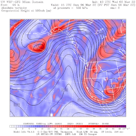
But there is more--something I have noticed over the years. La Nina conditions tend to result in large ridges of high pressure over the eastern Pacific, as we have observed frequently during the past months (see example below for Sunday morning). When the ridge is close to us, conditions tend to be cool and dry, but if it shifts a bit to the west, disturbances can move southward, providing showers and snow. That is happening today, by the way.
But late in the winter, the northeast Pacific ridge generally weakens, allowing more precipitation into the Northwest. So Northwest precipitation tends to be more frequent late in La Nina winters and during the subsequent springs.
And nearly all the forecast models are going for this during the next month or so. A cool, wet early spring.
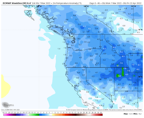
My favorite extended-period forecast model is run by the European Center and I will show you its long-term (46-day) forecast below (through April 22).
The forecast difference of temperature from normal is for colder temperatures than typical over the entire region. (blue indicates cooler than normal temps below)


The European Model prediction is consistent with the forecasts of others. For example, the U.S. Climate Prediction Center is predicting above-normal precipitation for the remainder of the month over our region.

What about the short-term forecast?
We have some light showers today from a passing system, but the real action starts this weekend, with heavy precipitation and snow in the mountains.
Below is the precipitation for the 72 hours ending 4 AM Tuesday. Yikes! Heavy rain (3 inches plus) from northwest California to southern BC. Plenty in southeast Washington.


I like the way you tie in the weather, events in Ukraine and the impact for wheat farmers. This is important to those of us who like our daily bread. Good job and God bless you my man.
ReplyDeleteDoes this mean more atmospheric rivers these coming months?
ReplyDeleteWith a strong ridge to our west over the ocean like the above weather pattern these types of systems are cooler and more showery in nature and tend to move in from the WNW. To get a strong AR event the ridge would need to be centered more to our south and East and moisture would then ride over it directly from the SW. Generally AR events are rare after this point in the season but of course it’s always a possibility still. I hope this helps.
DeleteGreat news! Thanks Cliff!
ReplyDeleteCool and wet now then extremely hot and dry this summer I'm not looking forward to 100 degree heat again in Seattle,yuk.
ReplyDeleteHow do you know about that extremely hot and dry summer at this point?
DeleteDear Caroline.
DeleteTim, if thats his real name, is just trying to scare you. Tim is being un-cool. (Insert winky face); I prefer the weather like I prefer the people, cool, very cool.
Climate change and the fact that we haven't had a cool summer since 2012 and commen Sense.
DeleteNo,no,and none apparently. We haven't had a cool summer since 2012? What defines cool? Where did you get your data?
DeleteTim'a statement that we haven't had a cool summer since 2012 is certainly true for the Wenatchee area, actually since 2011 here. Here is the average departure from the mean June thru August temperatures from the Tree Fruit Research Center, Wenatchee for this period: 2011 -0.2, 2012 +1.9. 2013 +3.8. 2014 +4.6. 2015 +5.8. 2016 +2.7. 2017 +4.7. 2018 +2.8. 2019 +3.3. 2020 +4.0. 2021 +7.6.
DeleteIs there an explanation for why one year is La Nina and other years are El Nino? I know it's driven by the water temperature and prevailing winds in the Pacific Ocean around the equator, but what causes the change in the prevailing winds?
ReplyDeleteTim talks about using "commen Sense." You can't make this sh-t up, folks.
ReplyDeleteCliff, will there be an in-person weather workshop this spring?
ReplyDeleteTo the cool spring predicted- Yuk! Looks like the whole NW quadrant! I was skunked off a climb in the Tetons last summer because of an early melt-out, which, on this route, leads to a rockfall hazard, so I rescheduled it for the first couple days in July. I hope I have not gone too far the other way. How does the summer look?
ReplyDeleteAnyone else notice how the IPCC report on global warming specifically used the term "existential threat" for islands and coastal regions? Someone over there must read this blog...
ReplyDelete