In a few previous blogs, I have criticized some of the media--such as the Seattle Times--for misinforming the public about extreme weather events.
Unfortunately, hypsters in the media have had help from those in government and academia, and there are few better examples than the latest claims about severe drought continuing in Washington State.
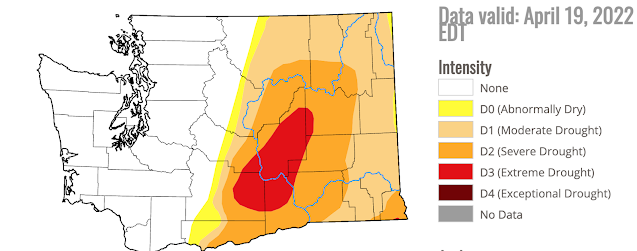
A case in point is the latest official Drought Monitor graphic for Washington State produced by the U.S. Department of Agriculture (see below). According to their analysis, about half of the state is in moderate drought, roughly a quarter is in severe drought, and about 10% is in EXTREME drought.
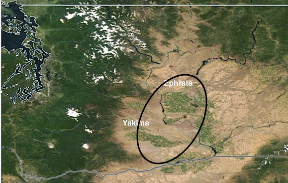
The extreme drought area extends from roughly Yakima through Ephrata (see satellite map below, with the "extreme drought" area shown by the black oval). Much of the "extreme drought" area is irrigated by water from the Yakima and Columbia Rivers and thus will not experience agricultural losses as long as those rivers have ample flow (which they will).
Do actual observations and climate data indicate extreme drought over eastern Washington?
The answer is clearly no. But you decide for yourself after reviewing the data.
Snowpack
Let's start with snowpack, and we are late enough in the season that the current snowpack tells us a lot about water availability this summer. The latest official snowpack numbers for Washington State are extremely encouraging--generally over 100% of normal, with lowest percentage of normal (Lower Yakima) being a reasonable healthy 78%.
Predicted River Flow Levels
Let's check both the critical rivers supplying water for the "extreme drought" region: the Yakima and Columbia.
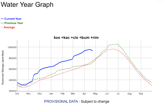
The reservoirs of the Yakima River are WAY, WAY above normal (see the latest graph of storage versus normal, below). Red is normal, blue indicates this year's values.
Amazing. The reservoirs right now are as full as they normally are in June after the spring snowmelt. With a big snowpack in place, there will be more than enough water for agriculture around the Yakima Valley.
The NOAA/NWS River Forecast Center in Portland has released its latest forecast of river levels in 120 days (middle of August), as shown below. The Yakima is projected to be at 140-150% of normal and the Columbia will be around 100% of normal.
No lack of water for irrigation or fish!
Soil Moisture
Well, what about soil moisture outside of irrigated areas? Soil moisture is certainly important for dryland wheat farmers in the Palouse area.
NASA has a satellite-based system to analyze soil moisture called GRACE. Below are the latest values nationally, with a blow-up for Washington below. Blue indicates ABOVE NORMAL values. Note blue over much of the extreme drought area. Other soil moisture analyses are similar.
Precipitation
Meteorologists like to look at the water year precipitation, the total precipitation from October 1 to the present, to provide an integrated view of winter moisture. For Washington State (see below), the water year was quite wet from the Cascades crest westward and near normal (light green and yellow) over eastern Washington.
But with all the talk of climate change and unprecedented "extreme drought", let's get a historical perspective.
Below is the water year precipitation (October 1-April 24th) for Yakima, WA since 1945. This year is slightly on the dry side, by many years (roughly two dozen) have been as dry or drier. Hardly exceptional.
Since there is concern about the unirrigated dryland wheat farms in the Palouse, here is the same graphic for Pullman. Pretty much near normal this year.
You will notice that there is little or no long-term trend in the precipitation record over the past 75 years....that is important. Eastern Washington has not been getting progressively drier under global warming.
The Bottom Line
The essential message is that weather and climate data do not support the claims of extreme or severe drought in eastern Washington this year.
There is no expectation of water problems over or near the Columbia Basin. The Drought Monitor graphics, which are created subjectively, are sufficiently problematic and deficient that they should not be considered or applied to any serious decision making.
The media loves apocalyptic and scary graphics for obvious reasons, but using these graphics to misinform the public is problematic at best and unethical at worst.
Finally, I should note that the big issue last summer was the extended extreme heatwave in late June. There is no reason to expect a repeat of that extraordinary, once in several hundred year, event.


.png)
.png)


Yeah, things are fairly normal. It is worth noting that the continued relatively cold and wet weather helps. Snowpack isn't based just on winter storms, but what happens in the spring and summer as well. Even when it is all melted, the amount of moisture in the ground and in the lakes, rivers and ponds depends a lot on the year-round weather.
ReplyDeleteSo what's the usda drought monitor based on? There must be some metric that is significantly lower than usual.
ReplyDeleteIt is done subjectively with unknown weights given to various inputs.
DeleteIsn't it based on the Palmer drought index?
Deletehttps://en.wikipedia.org/wiki/Palmer_drought_index
"and the Columbia will be around 100% of normal" Isn't that ... "normal"??
ReplyDeleteThe cpc is forecasting above normal temps this summer July through September so the more rain and mt snow we get now is good, hopefully there won't be any heat related deaths again.
ReplyDeleteThanks for your usual detailed and accessible analysis concerning the current, apparently “non-drought”, situation in Washington State. One question - at this time last year, was there any reason to suspect the forthcoming extraordinary, once in several hundred year, extended extreme heatwave in late June of last year?
ReplyDeleteThere was not reason to expect the extraordinary, ultra-rare heat wave.
DeleteMy wife and I always joke that the forest service sets their fire danger signs to "Extreme" in mid-July and leave them unchanged until October. It's starting to feel like the drought alerts - at least for Washington State - are similar.
ReplyDeleteI was suprised when I found that Bend Oregon has only gotten 3.08" of rain since 10/1, that is Mojave desert like. I don't think eastern Washington has been quite so dry but a 4 inch rainfall deficit means alot when the average annual precip is only 7 to 10". That area is always really dry so I don't think half the normal rainfal is the end of the world. What matters more than rainfall in this area is how much snow is in the mountains/how much water is in the resivors and we are doing good in both of these catagories. The fire danger might be alittle higher than normal this summer in the eastern Washington forests. The lack of rainfall east of the Cascades show that many of this winters storms have been weak/lacking dynamics. Its kind of odd to get weak storms in a La Nina year when we are supposed to get above average precip and stronger storms.
ReplyDeleteIt's especially shocking when you consider there's a ski mountain (Bachelor) just 20 miles from Bend that has gotten over 400 inches of snow this winter!
DeleteThis summer will be very hot and dry with the ongoing western drought sobbe prepared Seattle will experience triple digit heat again.
ReplyDeleteI can't decide if this comment is just a troll or actually something rooted in any kind of reality.
DeleteAnother excellent Blog Cliff. I greatly appreciate your thoughtful and analytical analysis. I was disheartened the other day when I heard the Nick Bond, Washington States Climatologist, say on a KUOW weather segment that last year's extraordinary heat wave may be expected every 5 to 10 years now due to climate change... I was shocked he made that statement...very unprofessional.. your thoughts? Thanks
ReplyDeleteDr. Bond's prediction doesn't seem that far-fetched given the weather experienced these past few summers and the overall upward temperature trends. The meteorological "dice" are becoming ever-so-slightly loaded in favor of these types of events, though they won't be as bad here as they might be elsewhere.
DeleteI think Nick is wrong about this. This event had a several hundred year return time.
DeleteCliff, what is the situation in Oregon this year?
ReplyDeleteGRACE is only the upper 2 cm of soil moisture. For the western Palouse dry land wheat areas the moisture for a decent crop requires two years of normal moisture and evapotranspiration; hence, if with a normal year of rainfall there will still be a deficit in moisture (they grow a wheat crop every other year in the western Palouse in order to get the moisture back up). Range land will similarly impacted. The irrigators should be ok.
ReplyDeleteDan.. that is not true. Grace provides deep moisture sensing. ...cliff
DeleteI would like to see a response from the USDA to your criticism. If I google "usda how are drought forecasts made" I get plenty of hits from USDA sites. But especially www.drought.gov. I think your reply above "It is done subjectively with unknown weights given to various inputs." appears to be somewhat of an oversimplification.
ReplyDeleteIn addition, you make no mention of depletion or recharge of groundwater resources.
HI Cliff - thanks always for your thoughtful posts - what do you say about this AP piece - saying Olympic Mt glaciers will gone by 2070? Climate alarmism or accurate? https://apnews.com/article/science-travel-parks-national-glaciers-b57c595cf6d557c25726bc14904c9882
ReplyDeleteI doubt that...but they will be reduced.
DeleteThe Anderson glacier that feeds the Quinault river disappeared 3 years ago. Lilian glacier, also gone.
DeleteI just heard a report on NPR that the southwest is in a 1200 year drought- Cliff do you agree?
ReplyDeleteCliff, I think you and Bill McKibben should have a match at the World Professional Wrestling ring. Meteorological celebrity edition.
ReplyDeleteMcKibben isn't even a meteorologist!🤣
ReplyDeleteThis is true...he has little background in weather and climate issues and much of what he says is simply not true.
DeleteI love you Cliff. Each and every time the hyperbole begins I can come here and read a straight forward report, without all the fearmongering and bias, to get the truth, facts, and grownup observations of a professional. Thank you!
ReplyDelete