My new podcast (see below to access), reviews the major changes occurring in the tropics and what they imply for our future weather.
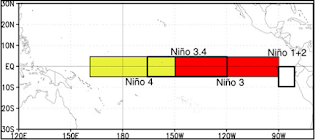
Our long-lived (3-year) La Nina is over, with the sea surface temperatures in the Nino3.4 area now nearly exactly normal (see below)
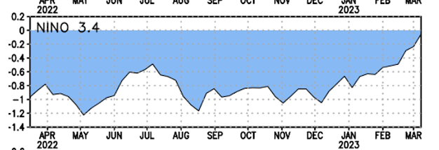
The Pacific sea surface temperatures went from about 1C cooler than normal in December to near normal today
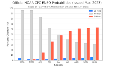
The latest NOAA Climate Prediction Center (CPC) forecast is for the probability of El Nino conditions to be over 50% by next fall.
As described in the podcast, the typical atmospheric configuration with El Nino is a low-pressure area over the Gulf of Mexico, warmer than normal conditions over the Northwest, and wetter than normal conditions over southern and central California (see below). But as demonstrated this year, long-term prediction has substantial uncertainties, with the guidance based on El Nino/La Nina more like weighting the atmospheric dice.

To listen to my podcast, use the link below or access it through your favorite podcast service.
Some major podcast servers:
Like the podcast? Support on Patreon


I bet It's gonna be a very hot summer now that la Nina is gone, yikes.
ReplyDeleteThe PNW experienced one of the hottest summers in living memory in 2001, and that was after La Nina was already in full effect. Causation does not mean correlation.
DeleteThis is exactly right.
DeleteThe "heat dome" of June, 2021, one of the world's greatest heatwaves on record, occurred during La Nina conditions (though, technically, the ONI, a measure of ENSO, was 0.1C above the official La Nina threshold at the time).
Additionally, though summer came late last year, when it did it struck with a vengeance. The summer and fall of 2022 were among the hottest and driest on record for Western Washington while the ONI was well below the La Nina threshold of -0.5C sea surface temperature anomaly.
In Bellingham, July, 2022 set a new record for fifth highest mean temperature for that month while August set a new record with the highest mean temperature for that month (third highest overall). September, 2022 set a new record with the third highest mean temperature and also tied with September, 2012 as the driest on record. Finally, October, 2022 set a new record with the third highest mean temperature for that month.
Based on the local weather records (at least for Bellingham - I haven't looked at any other data yet), it seems as though, historically (i.e. from 1950 to present), there was better correlation between La Nina events and cooler, wetter PNW summers. Perhaps in a changing, warmer climate there's some sort of decoupling occurring such that that correlation is weakening and likelihood of anomalously cool, wet conditions during summer is decreasing.
I would also add that muggy conditions with relatively oppressive dew points in the 70s and even 80s, apparently unheard of in Western Washington prior to the "heat dome" of June, 2021 were a most unwelcome feature of the summer of 2022.
DeleteThere were 6 days with dew points in the 70s at my location during July, 2022 including one day where the dew point reached 75F. August, 2022 wasn't quite as bad with "only" 3 days featuring dew points in the 70s though every day of the month had a maximum dew point of at least 60F - most unusual for our typically mild climate and quite uncomfortable unless one is accustomed to the climate of the Gulf Coast or summers in the Midwest.
In my research, I have found no instances of dew points in the 70s at BLI prior to June, 2021 and yet they apparently are now a regular feature of our local summer weather. Perhaps some sort of threshold has been reached or (I sincerely hope) the past couple of summers have been anomalous with regard to the heat and humidity - time will tell...
I didn't look at the data before responding (whoops!), but the comment below indicating that the summer of 2001 was not notably hot, at least in Seattle, is entirely correct.
DeleteIn fact, June 2001 had the 8th lowest mean temp for any June in SeaTac's period of record, July 2001 had the 11th lowest mean temp for any July and August was the odd man out with a very middle-of-the-road 32nd lowest mean temp for any August. Furthermore, June 2001 had the 3rd most precip for any June, July 2001 had the 24th most precip for any July and August 2001 had the 8th most precip for any August.
It seems to be the case that, for Seattle, the summer of 2001 was one of the coldest, wettest summers on record and quite characteristic of La Nina conditions.
The SeaTac period of record began January 1, 1945.
It would be an interesting project to go through the historical ONI data and compare it with the historical climate data for a selection of locations in Western Washington to determine how strong the correlation between ONI anomalies of -0.5C or less during summer months is with negative monthly mean temperature anomalies and positive monthly precipitation anomalies for the analyzed sites.
Hi Cliff,
ReplyDeleteI took a ride on Highway 6 from Chehalis to Raymond on Thursday, and was much surprised to see snow on the ground in a couple of clearcut areas in the Willapa Hills to the south, a reminder of the cool March weather we've had. I did not see this when I traveled that road a month ago.
My house backs onto Federal Govt land and they have spent the winter cutting trees and fire wising. I chatted to the crews and they said they are being told to except a dry/hot summer and active wildfire season. Normally i would think a strong snowpack such as this season is enough but we saw what happened in 2021 when several weeks of 90+deg decimated the snowpack even on the volcanoes. We shall see.
ReplyDeleteGot to 67 degrees at my house on Saturday, on the Bothell-Mill Creek line.
ReplyDeleteLatest IPCC report attributes to human-caused climate change, among other things, increased and projected further intensification of: hot extremes (virtually certain), global sea level rise and glacial retreat (very likely), and increase in heavy precipitation (likely).
ReplyDeletehttps://report.ipcc.ch/ar6syr/pdf/IPCC_AR6_SYR_SPM.pdf
By 2014 the Artic will have no more summer sea ice, and catastrophic sea levels will have risen. AL Gore 2007
DeleteNot sure what your talking about, Seatac only had 10 days in the 80's and no 90's in 2001 and that's a fact not my opinion.
ReplyDeleteIt was a typo, Greta. Figure it out.
ReplyDelete