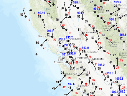
Today a record-breaking intense midlatitude cyclone has hit California--the strongest on record this late in the season. Take a look at the visible satellite image around 5 PM (below). An intense low center is at the center of the cloud swirl near San Francisco. While western WA and OR were high and dry!
A plane from Seattle to Monterey even had to abort its landing this afternoon due to large low-level wind shear. Moderate to severe turbulence was observed over much of California (see below, red is severe, yellow moderate). Not a good day to fly.
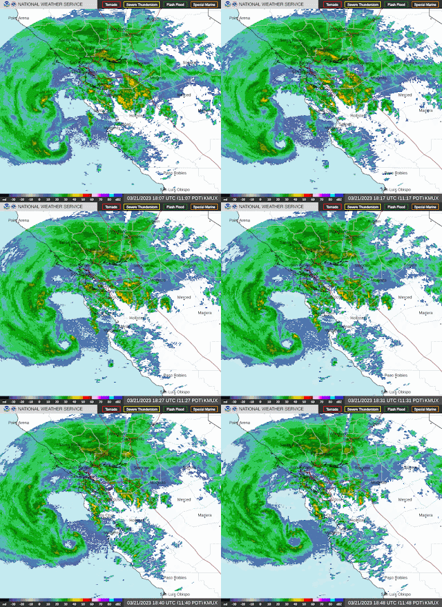
The National Weather Service radars along the CA coast revealed intense small-scale circulations embedded in the larger-scale low off the coast (see below). Just stunning.
Lowland Snow in the Northwest
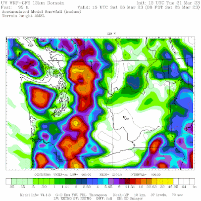
Normally, lowland snow is not an issue at lower elevations in the Northwest after early March. But much colder air will move into the Northwest later this week and there could be some snowflakes on Friday over western Washington and accumulating snow around Portland. The accumulated snowfall (not snowdepth) forecast through Saturday morning shows some light snowshowers over portions of the western lowlands. Substantial snow over the mountains.
Distrurbingly, southwest Washington and Portland areas gets more--several inches, with around a half-foot in a band south of downtown Portland. Portland is becoming the new Anchorage.😆
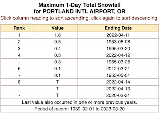
For some perspective, here are the record daily spring snowfall totals (March 20th and later) for Portland for the period from 1939 to today. The record is 1.6 inches. More is predicted by the UW WRF forecast.
In short, although there is substantial uncertainty for the lowland snowfall, there is a clear threat of lowland snow showers-- a rare treat this time of the year.


Before we know it it'll be in 100's again in Portland and possibly Seattle too, that seems to be the theme now the past several years.
ReplyDeleteTim it must be awful to live with such negativity, especially when it's not logical and is based on unscientific beliefs.
ReplyDeleteTim sounds more like a realist to me.
DeleteSince it's now astronomical spring, I decided to take a look at incoming solar energy (technically, irradiance) at my location in Bellingham for a comparison between the equinoxes and the solstices. Fortunately, there was very clear weather on or near each relevant date over the past year which allows for an apples-to-apples comparison. I measured cumulative solar energy of 25.17MJ/m^2 on June 24, 2022, 14.27MJ/m^2 on September 21, 2022, 4.75MJ/m^2 on December 21, 2022 and 14.16MJ/m^2 on March 18, 2023.
ReplyDeleteCumulative solar energy is equal on the equinoxes, almost 3 times greater on the equinoxes than on the winter solstice, and more than 5 times greater on the summer solstice than on the winter solstice.
It's interesting how the absolute change in solar energy between the equinoxes and the solstices is similar while the relative (i.e. percentage) change between the equinoxes and the winter solstice is nearly twice that of the relative change between the equinoxes and the summer solstice.
Because the vernal equinox is still well within the official PNW wet season, which extends from October 1 through April 30, the strength of the incoming solar energy at this time of year can seem deceptively low especially when compared with the weather that's more typical of the autumnal equinox which, while on the cusp of the wet season, is still within the official dry season despite the fact that the incoming solar energy on each date is equal, or very nearly so.
Also, when comparing the typical weather of the summer and winter solstices with that of the autumnal equinox the significance of the larger relative change in solar energy between the autumnal equinox and the winter solstice compared to that of the summer solstice and the autumnal equinox is thrown into sharp relief. Even though the absolute decrease in solar energy from the summer solstice to the autumnal equinox is similar to that from the autumnal equinox to the winter solstice it seems as though the decrease in solar energy between the latter dates is much greater than the former due in part to the substantially larger relative change as well as the onset of the wet season.
Cliff, or anyone who reads this, I’m wondering if you can confirm a number I ran. I estimate that melting 2” of snow (simply moving from frozen to liquid state at 0 degrees C) across the 472,258 occupied acres of Whatcom County requires approximately 4 times as many joules as the 220,000 humans here use in a year. I used 0.76 kg per square foot of snow that is 2” deep. Annual global energy consumption is estimated at 5.8 x 10^23 joules. Melting ice requires 3.34 kJ/kg.
ReplyDeleteHere is another fascinating discussion from Juan Browne of the Blancolirio aviation safety channel. This one concerns the history of flooding in central California and what the Army Corps of Engineers is now doing to deal with recent heavy rain and snowfall:
ReplyDeleteCalifornia Flooding 22 March 23 Tulare Lake
When are we gonna get some of the action California's getting? This is unfair!!!
ReplyDelete12 major atmospheric rivers and 2 minor ones since December, a bomb cyclone, and a tornado in LA?? This seems like a 3 sigma year for them.
ReplyDelete