On an annual basis, Seattle gets more precipitation than Portland (39.34 versus 36.91 inches).
But there are often periods, particularly in Spring, when Seattle is considerably drier.
The fact Seattle is generally wetter makes sense: the jet stream and wettest conditions are generally found over the northern portion of the U.S. West Coast and in British Columbia. Seattle is in the primo meteorological "hose" more often.
But at times, Seattle is drier. And it turns out that the Olympic Mountains are a big factor.
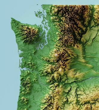
When the winds are from the west, Seattle is in the rainshadow of that large mountain barrier, while Portland is downstream of much lower coastal mountains, which allow more precipitation to pass (see terrain map below).
And it happened this week.
Consider 6 AM on Friday. Below is the radar image at that time. Lots of showers coming in from the coast. The showers were enhanced as moist, unstable air was forced to rise by the western slopes of the Olympics. But as the air descended on the eastern side of the Olympics, it warmed and dried, producing a profound rain shadow over Puget Sound country.
As the air is forced to ascend by the western slopes of the Cascades, more showers developed.
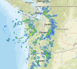
Portland was not so lucky, with the far lower coastal mountain allowing Pacific showers to reach the Rose City.
And just to prove the wind direction was westerly (from the west) that morning, here is the vertical sounding from the balloon-borne radiosonde at Quilayute, on the north/central Washington coast. The wind barbs on the right show the direction and speed. The heights are in pressure: 850 is about 5000 ft. Westerly winds confirmed.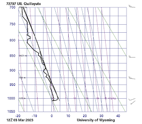
During mid-winter, the coastal winds are generally southerly or southwesterly in the lower atmosphere. As a result, the Olympic rainshadow rotates to the north and northeastern side of the Olympics, providing drier conditions from Port Townsend to Sequim That is why folks retire there! Lots of dry days to play golf or take a stroll.


It would be interesting, to see which areas of Puget sound are most affected by the notorious "convergence zone"...I am guessing that places like Edmonds, Lynnwood, etc get the most action in that regard. I have noticed that when I occasionally drive to Edmonds, the cloudiness builds up, and rain does happen...then, on my way back to Everett--the rain
ReplyDeletefizzles out.
This blog seems incomplete without some explanation for why the mean wind direction shifts from south/southwest to west as the wet season comes to an end and the dry season begins.
ReplyDeleteHi Cliff. Sorry this is off topic. I'm visiting my mom who lives just SW of Ellensburg, and Saturday evening there was a winter weather advisory for 2-4 inches of snow. Not a flake fell. Then Sunday there was no snow in the forecast until about 6:30pm, when it forecasted snow showers for the evening with less than an inch accumulation. About two hours later it started snowing and became very heavy, dropping about four inches of wet snow in about two hours. So I'm just curious if you have any thoughts on why these forecasts were off, and on any difficulty forecasting snow here on the east slopes(I know it's very difficult in Western Washington). Also, that snow was coming up directly from the south, and I grew up here and have always noticed the biggest snows have happened when moving up from the south, along the east slopes of the Cascades. I'd be curious to know if there's anything to that, and if so, what the causes are for this. I know you are busy, but hoping you can find a second to address this at some point. Thank you!
ReplyDeleteIsn't it about time we had a warm spell- Pineapple express or at least one of those sunny 60-ish "false Springs"?
ReplyDelete