We have some interesting weather ahead.
The key features will be the development of a strong upper-level ridge over British Columbia and a low sliding westward across southern Oregon (see upper-level map for 8 PM Sunday).

There are some suggestions in the media and a few blogs that this situation is like June 2021. This is not correct. The shape, size, intensity and location of the high are different (and much less intense) and the low center was absent in 2021. Subtle differences are everything.
So let's go through the next few days in detail.
Today (Thursday) has been near perfect, with low 70s around the region at 3 PM.
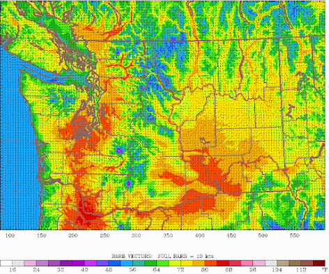
The predicted temperatures at 5 PM Friday are shown below. Cooler along the coast and Northwest Washington. Just reaching 80F in Seattle, but warmer (low to mid-80s) over southwest Washington and the Willamette Valley. Also low 80s in the lower Columbia Basin.
On Saturday at 5 PM, high temperatures will increase by roughly 2-7F (see below). If you don't like heat, head to the water or northwest Washington. 80s will be extensive away from water from Everett southward and temperatures will warm towards the Cascade foothills. Much warmer in the Columbia Valley. Portland could get into the low-90s. Mid-80s for Seattle away from the Sound.


If the Weather Channel forecast verifies, this will be one of the most significant May heatwaves in Western Whatcom County history with many locations setting monthly record high minimum temps and possibly record high daily mean temps as well.
ReplyDeleteFriend...where are you getting this stuff? This is NOT going to be a big deal in Bellingham (which is in western Whatcom county). Highs getting into the lower 80s. Has done this many times before. Many locations are NOT going to set monthly records...cliff
DeleteTWC is notorious for hyping anything and everything in order for more clicks and $$. For recent evidence, they started naming storms (!) that were nothing more than common occurrences. Pathetic.
DeleteI found a source for Bellingham that claims: For May, the hottest day on record was May 29, 1983 when the temperature hit 90.0°F.
ReplyDeleteWeather.com is showing 7 80+ days for Seattle if that happens it will be the first time on record, I believe that's what friend is referring to more than anything else but I could be wrong. Yes we had 80+ days in May before but not this many.
ReplyDeleteThere was a viral twitter thread talking about how fuel oil in container ships had lower Sulfur content threshold starting in 2020, leading to lower particulate in the atmosphere and subjecting us to higher temperatures.
ReplyDeletehttps://twitter.com/LeonSimons8/status/1633566568528375811
https://www.imo.org/en/MediaCentre/PressBriefings/pages/03-1-March-carriage-ban-.aspx#:~:text=The%20IMO%202020%20regulation%20limits,sulphur%20oxides%20in%20the%20air.
I told my wife, connecting it to our PNW heatwaves, so of course she said "Yeah, but what does Cliff Mass say about it?"
What about the increased particulate from the large number of fires that occur now almost every year?That should offset that. The cause of these seemingly more common heat events is a highly amplified upper level pattern which certainly does seem to be, in some way, affected by Climate Change (warming Arctic, wobbly jet stream, larger west Pac typhoons taking a northern recurve track). All these events can lead to a amplified upper level pattern that has been dominating our weather recently especially our summers.
DeleteThere is the possibility of some smoke moving into the region later on Saturday as the flow switches to strongly offshore from the East. There are some huge fires in Alberta and Northern BC already ,far above normal in terms of acres burned and fire starts.
ReplyDeleteBLI set a new daily record high temp today with a measurement of 79F breaking the previous record of 77F set in 2002.
ReplyDeleteInslee was just on TVsaying this warm weather is more proof of climate change. Is he right?
ReplyDelete"Among global weather stations having at least 40 years of record-keeping, Herrera documented 762 that exceeded (not just tied) their all-time heat record in 2022; just four stations with a long-term period of record-keeping set an all-time cold record. For comparison, 404 stations set their all-time heat record in 2021 and 54 set their all-time cold record."
ReplyDeleteHQM set a new monthly record high temperature on 5/13 with measurement of either 89F or 90F breaking the previous monthly record high of 87F set in 2007. If 90F is official, it will be the earliest such reading at that site on record by more than 2 months. The period of record begins 1953.
ReplyDeleteAny info on the wildfire situation Cliff? There are large fires in BC and my friend informs me of a fire start close to Whistler, BC. This makes no sense as it was a seriously wet and heavy snow year and here we are May 13th and fires are burning.
ReplyDeleteI was wondering how this heat combined with a cold spring and higher than average snowpack in the mountains compares with the Vanport flood on the Colombia in 1948.
ReplyDeleteInteresting Post!
ReplyDelete