There has been a lot of talk about the warmth of this weekend, but the REAL story is about the winds, not the temperatures. Unusually strong easterly winds.
Today was a warm, but pleasant day for many, with Seattle getting up to the mid-80s away from the water, while highs hit around 90 from Olympia down into the Willamette Valley.

But the warmth was mitigated by a wonderful breeze in many locations, with the high winds today reaching around 20 mph over western Washington/Oregon and 30-35 mph east of the Cascades.

The weather situation today and tomorrow are very different from the major heatwave events and that explains the winds.
Considering the upper level (500 hPa) pattern, one notes an elongated ridge of high pressure/heights to our north, which is NOT the canonical location/shape to give the Northwest a major heatwave. A further non-standard feature is a low center to our south.
All of this is VERY different than the situation in June 2021.

This pattern is producing an intense north-south pressure gradient over the region, resulting in very strong easterly (from the east) winds, as illustrated by the situation around 5000 ft (850 hPa pressure level) around 11 PM tonight (see below).
Very strong easterlies. And this pattern is bringing in cooler air from the east (color shading shows temperatures, with red being the warmest). Again, not optimal for the warmest temperatures.

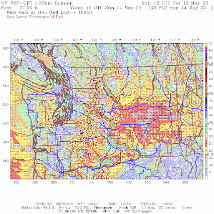
The UW WRF model is predicting very strong surface wind gusts tomorrow morning over eastern Washington, with some winds hitting 40 mph (see below). There will be blowing dust.

To get an uber heat wave around Seattle, the thermal trough of low pressure has to be right over Seattle, not to our south. This is why we won't go crazy warm tomorrow.
These easterly winds over our region will be unusually strong, as indicated by the forecast normalize anomalies from climatology tomorrow morning for wind speed around 800 meters above sea level (see below). Up to 4-5 standardized anomalies over eastern WA, which indicate a very unusual situation.

The easterly winds will enhance warming over the western slopes of the Cascades due to downslope compressional warming.
Temperatures tomorrow should be slightly warmer than today over western Washington, with highs between 84-89F away from the water around Puget Sound, and a bit warmer to the south (see forecast temperatures at 5 PM Sunday below).
.gif)
A transition to cooler temperatures will occur late Monday.
Enjoy Mother's Day and watch for dust in eastern Washington.


Are we beginning an early start to summer drought, or can we expect some more rain and cooling as we get into June?
ReplyDeleteThis is on my mind as well. Not looking good for forage and hay
DeleteIn my experience, Mays have been less rainy than Junes (farmers historically tried to get "first cutting of hay" in late May here in Whatcom). Mediterranean climate that this is, the seasonal dry period (AKA "summer") is typically July, August and part of September. I'm pretty sure that "drought" is something else entirely; officially [per drought.gov] "Defining Short- and Long-Term Drought. If a weather pattern that results in a precipitation deficit lasts for a few weeks or months, it is considered short-term drought. If the pattern and precipitation deficits last for more than six months, it is typically considered long-term drought." And in Washington where it comes to deficit: "...the legal definition of drought is based on water availability. A drought emergency is declared when water supply conditions are expected to fall below 75 percent of average, and there is potential for undue hardships due to low water supply." If there's ample groundwater and melt, supply may be okay even if it's not raining every day. Even with that rare temp spike last summer, I didn't need to water lawn & garden, but we're not in a rain shadow.
DeleteSouth Hill Puyallup went from 61° at 430 am to 74° at 630 am this morning. Looking at other personal stations it seems to be a fairly localized quick warm up. Winds are strong and the dew point dropped 6°.
ReplyDeleteWind started at 7 am at KELN Ellensburg and speed has increased to about 20 mph with gusts to 30. Ritzville is higher. Full sun. Not nice being outside in the wind and sun.
ReplyDeleteIt was cooler than forecast in the Bellingham area on 5/14 though there was little wind. Nearly stagnant conditions at BLI with a max gust of just 9mph as of 6PM. The dew point temps were uncomfortable again: in the 60s. NWS Seattle reports that Hoquiam officially reached 90F, the earliest occurrence of a 90 degree measurement in its 70 year period of record by more than 2 months.
ReplyDeleteI'm curious how the current conditions with above average snowpack and colder spring, and sudden warming compare with the 1948 Vanport on the Columbia.
ReplyDeleteA few miles north of Arlington it's blowing a good 35mph from the north east again this morning, does it everytime there's a thermal trough over the coast, looking forward to some Thunderstorms over mountains today
ReplyDeleteThese wind patterns are fascinating; it's nice to know what's stirring. I expect there are general seasonal patterns, but not highly-predictable ones. I dread the term "wildfire season," but in recent years when it's been smoky [S->N, E->W counter-clockwise] action seems to predominate until fresh W->E ocean breezes return. I expect that the precision (probability) of the seasonal patterns is limited, and it would utterly mad-hatter to expect the same breezes to occur on 'same dates' at ground-level. My guess is that there's a fair amount of cross-pollination between between the flight/airline industry ["route people" & pilots] and "atmospheric science" folk, yes? (FAA <-> NWS, NOAA, etc) re these patterns, if there are seasonal patterns. Tell us more!
ReplyDeleteProf: Another minor question (or matter). I see "high temps" on maps, and in a lot of newscasts, but I know that some peak temperatures are fleeting. Is there a method by which atmospheric scientists (weather folk, climate folk) calculate the actual "warmth" of a day? I can't see averaging temperature over 24 hours ...meh. Maybe average temp during daylight hours would be useful. Here I'll see a high last only five or ten minutes, then drop back to a gentle curve (then tank when the sun sets). Throw in an evening thunderstorm ...well, you get the picture. 'Just curious to know if highs are factored somehow by the more sophisticated models. For example, do any models use temps taken at a meaningful local-time, like "solar zenith"?
ReplyDeleteCliff, today 5/15 around 7-8pm here in Kirkland there was a rapid cooldown of what felt like a 10 degree drop accompanied by gusty winds. Despite this there were no clouds or precipitation. Could this be "downdraft" winds caused by the thunderstorm activity to the east of us?
ReplyDelete