Numerical weather prediction has improved dramatically over the past decades, providing potent warnings for extreme weather, such as hurricanes.
There are few better examples than the prediction of Hurricane Lee, which will make landfall near the Maine/New Brunswick border late Saturday.

The U.S. global model, the GFS, has been spectacularly skillful in predicting this storm, well more than a week ahead.
The latest forecast run shows the storm making landfall near the international border around 5 PM PDT on Sunday. That is a 54-h hour prediction This is so close enough in time...and so consistent with other model forecasts... that you can be assured that this is close to what will happen.

The 72-h prediction is pretty much the same.

The 126 h prediction is nearly identical in position:

The 198 hr (8.25 day) forecast has a strong hurricane in pretty much the same location.

Folks, this is a stunningly good forecast for over a week ahead.
Professor Brian Tang of the University of Albany has a wonderful website that verifies the hurricane track (position) forecasts of major modeling/forecasting systems. The results for Hurricane Lee are shown below for forecasts of 120 hours (5 days) or less.
In general, the track accuracy gets better for shorter forecasts...which makes sense. But let's compare the American model (blue color, AVNO), the European Center model (red color), and the UKMET office model (green color). The human (official) forecast is shown in black.
Wow. The American model is STUNNINGLY accurate at all projections in time.
It is FAR better than the nominally top two global modeling systems in the world: the European Center and UKMET. The forecast error is under 100 km (60 miles) for all projections shown.
Extraordinary.
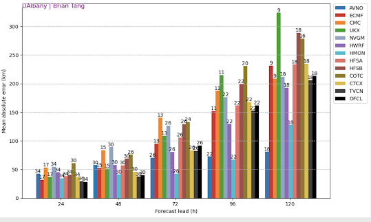
The model forecasts are better than the official Hurricane Center forecasts....I suspect that humans are probably hedging their bets with the European Center model solution.😅
This was a truly excellent forecast and not the only success for the American model this season. Hopefully, this extraordinary performance will be persistent for future storms, perhaps reflecting recent improvements in the U.S. global modeling system.
Finally, I should note there are real policy implications of the rapidly advancing weather prediction skill now available to decision-makers. Excellent forecasts can help protect people and economic assets from extreme weather.
Better forecasts are the first line of defense against severe weather.
Better forecasts have great potential for reducing the negative impacts of global warming.
One of the reasons I have spent some time trying to calm down some who are panicking over global warming and extreme weather.
Climate-related deaths are down...and I mean WAY down. Better adaptation and a richer world have contributed, but so have better forecasts.

Importantly, we have only begun taking advantage of improved forecast skill.
The winds on Maui were nearly perfectly predicted on August 7-8 of this year, yet 115 people died and nearly 10 billion dollars in damage was done. We could have easily stopped the carnage, by shutting off the power and effectively evacuating the population.
Most major wildfires are related to strong winds and such winds are often forecast with great skill. Few should be a surprise.
In summary, coastal New England has had nearly a week to prepare for strong winds and heavy precipitation (over northern Maine)-- and we can be proud of the technological advances and investments in NOAA and in other government agencies that made such forecasting prowess possible.


Nice work with the hurricane! Now let's hope we get the 1 to 1.2 inches of rain predicted for my neighborhood next week on your last post. Some of the other forecasts are not so sanguine.
ReplyDeleteWhat!? I'm going camping next week!
DeleteCliff, any ideas what will happen when Lee meets Bay of Fundy tides?
ReplyDeleteMost of the models seem to have gotten close to 200km error 5 days out. For a storm that is likely to be destructive over more than a 200km wide path, it seems like all of them achieved invaluable levels of accuracy.
ReplyDeleteRegarding the GFS and the European Center model - it seems like most often you heap praise upon the latter, so I'm curious first of all - was the GFS's great performance predicting this storm's track typical, or is it a one-off?
And do these two models trade merits back and forth? For example, is the GFS better at predicting how a low might move or wind speeds while the European model might be better at predicting precipitation or temperature?
I 'm looking at the ECMWF model which is showing the storm swinging more the west brushing Cape Cod and subjecting the New Engand cost to significant rain and wind.
ReplyDeleteCliff, thanks for the info on Hurricane Lee. I'm visiting friends in St John, New Brunswick currently and we are monitoring the storm closely. Any suggestions on prepping for a hurricane? We are all PNW natives and have never experienced a hurricane before.
ReplyDeleteI lived in CT once. Hopefully your friends are a reasonable elevation above sea level (say 30 feet or better), otherwise they should leave. Secure outside furniture, and cut away large tree branches if they hang over the house. Anything large that might blow over (travel trailers, boats, etc.) should be secured and/or moved away from the house. Shutter windows if you have then (traditional New England houses often do). Anything that might blow around the yard (toys, garbage cans, flags, laundry, potted plants, etc.) should be brought inside or under cover. Get lanterns and camp stoves ready in case you lose power.
DeleteI have been in one East Coast hurricane and it was beyond my imagination. My neighbor died while dealing with a downed tree and making contact with downed live wire. The town had no power for 2 weeks, except for police and school. And people went to school and lined up everyday for showers. Roads were closed because of trees every which way on the roads. So not much travel going on. Restaurants opened to feed the town, and used candlelight. Basically, you are in survival mode. It was awful. Avoid unless you can live without power, do not have to travel anywhere, are ok with cold cuts and Red Cross food and happy with board games. Are you strong enough to lift tree limbs?
Delete"Climate-related deaths are down...and I mean WAY down." Which is exactly why the doom - mongering AGW crowd only discusses FUTURE deaths if we don't do something immediately, according to their wishes. So much easier to pontificate on things which can never be substantiated by any objective measurement.
ReplyDeleteOfcourse. Also feed into the narrative that migrants are fleeing disasters and that AGW is "making" places deadly and not livable anymore which warrants asylum.
DeleteEverything falls under the same rubric. AGW, is there anything it can't do?
Delete"Public health officials in Maricopa County, Arizona’s most populous county and home to Phoenix, said this week that 202 heat-associated deaths had been confirmed for 2023 as of Sept. 9; far more than the 175 confirmed by the same time last year."
DeleteThis is substantially a drug-abuse problem:
DeleteA majority of heat deaths in Maricopa County are attributable to methamphetamine, according to the latest Maricopa County Department of Public Health heat deaths report. 53 percent of heat deaths involved meth last year, or 226 deaths. 67 percent of deaths involved some type of substance abuse.Jul 27
What an amazing accomplishment. It is too seldom noted that current (and future!) technology has a remarkable ability to ameliorate the most dire of predictions. Also glad to see you acknowledge stunning rise in global wealth, another modern miracle that goes shamefully ignored.
ReplyDelete