Perfect temperatures, no rain, and little smoke.
What is left to say?
Substantial rain last week has knocked back the smokers in British Columbia and there are only a few small fires over the southern Cascades. FAR less fires than normal in fire-prone California.
Thus, the latest Purple Air surface air quality sites indicate mainly green colors (good air quality) over the Northwest, including much of southern BC.


The latest weather.com forecast for Seattle suggests a slow warming into Saturday, but nothing extreme...77F. (see below)
Close to perfect. Followed by a modest cool-down next week.

Eastern Washington will top out around 90F over the weekend.
I really wish I could forecast some weather excitement, but we have a boringly optimal period ahead.
But changes are occurring to our north and west. The temperature difference between the subtropics and Arctic regions is growing and that helps drive the upper tropospheric jet stream, centered around 30,000 to 35,000 ft.
The figure below shows the winds around 30,000 ft next Tuesday, with the jet stream indicated by the stronger winds (green to orange and red colors). The jet stream, which acts as a conduit for storms, will be headed into BC.
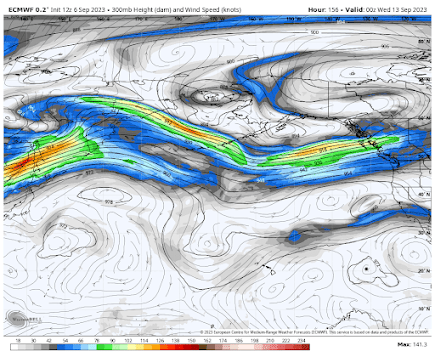
With a persistent jet stream to our north, BC and southeast Alaska will get plenty of precipitation (see total through Wednesday below). Gray and reds are the most.

During October the jet stream will slide south and the moisture stream will reach us.
But enjoy perfect weather in the meantime.


Seems to me quite often on September 30th the weather can change on a dime. There have been a number of years where starting on September 30th, clouds and rain began and continued until spring.
ReplyDeleteI'll just sit here with my mouth open like a dog playing with a hose until the jet stream gets here. It's been a long, dry summer.
ReplyDeleteAre the effects of El nino are already happening with this dry/warm pattern were in?.
ReplyDeleteCliff - would love your take on the most recent NMME runs. It looks absolutely gruesome for PNW winter.
ReplyDeleteIts always beautifully warm and dry for the summer in the PNW. At least 2 if not 4+ months with less rain than the entire country. Always makes me laugh when people seem surprised or claim its a "dry summer ". Its always dry! Haha
ReplyDeleteThat being said, i had my fun in the sun. Cant wait for some rain in October. It will come, just like clockwork as it always does.
It's too dry for me. A couple days of meaningful rain each month really helps makes summers much more bearable for me. My area got slightly over 1/2 inch last week, which helped significantly, but the early models were calling for well over 1 inch, so it ended up being a bit of a disappointment.
ReplyDeleteIn any event, the parched feeling is returning, and I was hoping not to have to wait 10+ days for another meaningful soak, especially not when I think about the graph you've shared a couple times indicating the chance of over 0.01" of precipitation is around 30% this time of year.
Cliff, I too start to miss the "excitement", as you say- having grown up on the East coast where some sort of weather excitement is possible any month of the year. I am ready for the Pineapple Express to bring this year's precipitation up closer to normal... and knock out the rest of the fires.
ReplyDelete