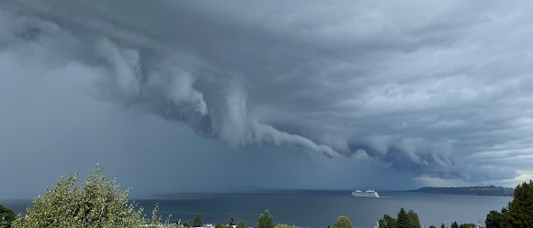
Take a look at an amazing image taken around 12:15 PM yesterday by Murphy McCullough. A bizarre convoluted line of clouds stretched to the horizon.
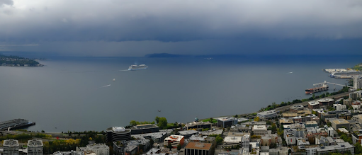
This video is real--not the creation of AI or some Hollywood disaster flic. Just to prove this to you, here is a view from the Seattle PanoCam, located on the Seattle Space Needle at 12:10 PM
The shower line was made up of a series of strong cumulus convective elements, including thunderstorms.
The flow at the leading edge of the gust front--with strong, cold sinking air behind and warm, moist upward-moving air in front of it-- can be turbulent. leading to tendrils of upward motion that produce unusually fractured clouds. That is what they are called fractus clouds!
A lone cruise ship was heading into the terror.....would it survive?
Murphy was a brave soul and he took an extraordinary video, which is shown below.
Particularly terrifying were the torn-up, fractured clouds hanging out of the general cloud feature. Surely the work of some Lucifer-like creature.
You can see the cruise ship heading into the murk. Reminds me of the movie "Final Countdown" in an aircraft carrier moves into such a feature and comes out at a different time.
Ten minutes later, the line is approaching Seattle and the ship is gone behind a curtain of rain....or is it something more ominous?
So What Was It?
A strong convective line, made up of thunderstorms and heavy showers, was moving through and the ominous feature you see is called a shelf cloud.
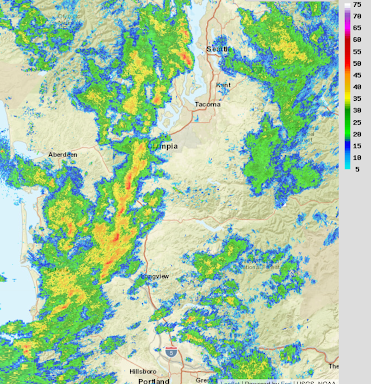
Let's begin by showing you the radar image right before the images above (12:07 PM). Red is very heavy rain or hail. Orange and yellow are just heavy rain. You see the corrugation of the feature....another indication of a powerful line.
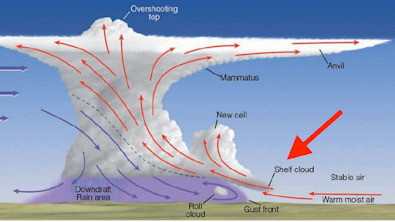
Leading the strong storms was a cool outflow of powerful winds....called a gust front. The gust front pushed air up ahead of it, producing a shelf cloud (see schematic below)
The flow at the leading edge of the gust front--with strong, cold sinking air behind and warm, moist upward-moving air in front of it-- can be turbulent. leading to tendrils of upward motion that produce unusually fractured clouds. That is what they are called fractus clouds!
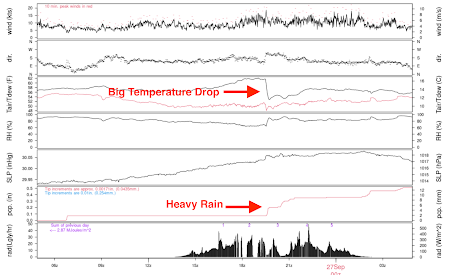
And when the line went through, the weather got very interesting. A profound drop in temperatures, an increase in winds, and, of course, heavy precipitation. Check out what happened as the line passed across the UW (see below).
And the weather fun is not over. An intense mini-low moved across the Oregon/Washington border, bringing strong winds to the northern Oregon coast (see forecast map for 2 AM today).



Looking at some of the pics from yesterday brought up some bad memories from my decades in the Midwest. Those shelf clouds often spawn multiple tornadoes, something this area rarely experiences (thank goodness).
ReplyDeleteJohn - you better believe it is indeed a bad memory when you view a tornado touch down less than two miles away from your home, and watch it proceed to destroy the surrounding farms and subdivisions in it's destructive path. No one living in tornado alley thinks these are part and parcel of good memories, but if you want to think of them as great ones, you do you, and try to think of those less fortunate in the future.
DeleteMy comment was that I found tornadoes terrifying, while you thought they were awesome. I have personal experience with them, while it's obvious that you do not. Different perspectives, but why you chose to come in and offer your own counterpoint only you can explain.
DeleteYou were not kidding about this huge weather front the other day. It rained much of yesterday, and at 8:30 currently today, it's pouring out there. I did not see anything like the shelf cloud yesterday but obviously it looked like it went the length of Puget Sound and then some according to your radar image here.
ReplyDeleteBecause of this, I've transitioned to the cooler weather foods that will favor hardier dishes and red wine now. I guess I will have to dig out the flannels and put them on the bed.
The video of the ship heading into the storm cloud was quite interesting and it did look ominous indeed.
Flannel and wine in the rain! What could be finer?
Delete74 years in the NW, and I've never seen it rain like it did coming from under that beast. And dark? I thought it was the end of the world.
ReplyDeleteI was on top of Maple Leaf Reservoir Park when the cloud approached. Up until then, it had been fairly dry and mild. The wind picked up a little when it was overhead, but mostly it was just interesting to look at. A little while later is started hailing, and then raining really hard. Eventually I got shelter, but holy cow, that was a lot of rain. Eventually there was some thunder and lightning (although not nearby). Then a little while later, it stopped raining, and was nice again. Until the next round of rain.
ReplyDeleteTL;DR some weather happened
DeleteFabulous photos and information, thank you! I saw some absolutely fascinating cloud action -- churning, really -- columns shooting skyward and melding with others (so hard to describe, would have made for great video if I had super camera equipment) last night and this morning. For what it's worth, there's fresh snow in the mountains just above, here in Glacier (I've sent photos to Prof Mass) -- 9-28-23, pretty early compared to last year's first snow on 10-22. Who can resist wild, ever-changing weather??
ReplyDelete