Today was cool, mostly cloudy, with some showers. There was a real autumn feel to the air. Days are rapidly getting shorter and the strength of the sun is noticeably less.
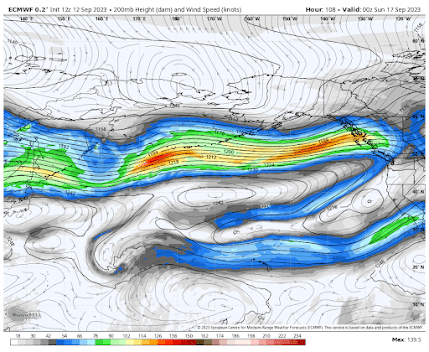
Rapidly, the jet stream...the strong west-to-east current of air in the upper troposphere.. has strengthened....and the forecast of upper-level winds for Saturday afternoon shows a strong current of winds extending across the Pacific (see below). Reds are the strongest winds.
The jet stream is driven by the north-south temperature difference, so as the Arctic rapidly cools, the temperature change and associated jet stream strengthen.
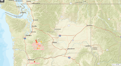
Right now, most of the jet stream action is north of us, but late Sunday and Monday, western Washington and BC will get a piece of it. Below is the 72-hour total precipitation ending 5 AM Wednesday. Wow. Southern BC will get some heavy rain.


Not very El nino like with the cooler/wetter forecast.
ReplyDeleteI enjoy how September has been pleasantly winding down...but I do hope that BC rain action drops down to Puget Sound...I miss having some serious rainfall, and we are overdue for a day or two of decent mini-squalls!
ReplyDeleteDo you think the weather this October will be more or less normal? What are the chances it'll be like last year with weather in the 70s deep into the month with a sudden, overnight transition into cooler fall temps?
ReplyDeleteThe recently European model run is much dryer for western wa compared to the gfs.
ReplyDeleteHey Cliff its a bit outside your usual range of North America but would you consider writing something up about the flooding in Derna, Libya. Seems like they must have gotten an incredible amount of rain to cause those dam failures.
ReplyDeleteThe dams were poorly constructed, ill-maintained, and recently had no water in them. They are easy to find using Google Earth Pro. Current image is from June. Southern most dam is at Lat/Long: 32.65927, 22.577404
DeleteThis summer will apparently be the driest in history for Seattle, with under 0.5 inches of rain. The next two driest: 2017: 0.52, 2022: 0.50 [source: King5]. We had decent rain in the spring, so we're "only" 35% short of average rainfall for the year (14.56 vs 22.33). But three months of dryer and warmer, year after year, means death for plants and trees (see article in Columbia Insight about western red cedar). Interesting times for NW ecosystems! Sorry for the bad news - I LOVE the beginning of fall, and this time in the NW is my favorite.
ReplyDeleteYou are not correct. This is NOT the driest summer on record. At SEATAC it is the TENTH driest June-August.
DeleteIt looks like King5 used the astronomical summer period (June 21 to Sept. 21) as their definition of summer for computing the rain amounts for the dry summers of 2017 and 2022. If you use that definition then this summer's rain total at Sea-Tac up thru today would total 0.54 which, if no more rain fell before Sept. 21, would not be a record, but could be the third driest such period at Sea-Tac.
DeleteThe statement of this being one of the "most benign wildfire seasons in years" is a somewhat subjective one, using the tactic of select statistics, in the case I believe the total number of wildfires statewide. There are other statistics and events that would suggest that this has been a busy and deadly year for wildfires- the Puget Sound Regional Fire Authority reported publicly last month that they had responded to nearly twice as many brush fires as the year before. Last month, a brush fire spread to a mobile home park in Lakewood, destroying 9 homes and killing two, an extremely rare event in Western Washington. I'm definitely not waving the flag of gloom and doom like The Seattle Times, just pointing out that it's quite easy to present a conclusion about the recent wildfire season (either benign or severe) and cite facts to support that conclusion. From my own perspective, the only thing that has kept this season from being near-historic in Western Washington has been the lack of wind events.
ReplyDeleteThis is a benign season by many measures. Very low in total acreage as well. You are right....the lack of big events was a major aid. But that was foreseeable....that is why I was going for a benign summer from the beginning. Wind is FAR more important than most realize.
DeleteMedia and government needs to acknowledge the differences in "wildfires". What I mean is natural vs human caused. They want to blame man made climate change, but truth is mostly it is just stupid man. Just read that back and find it funny we are still able to use "man" as the descriptor, only if dirogitory i guess, I digress. But in the case of wtf255, I would suggest that more people living outdoors contributes to the increase and just a general sense of "I never worry about fire we are wet green westside" attitude and people being careless during a dry time. Not drier, just dry. Same to eastern washington people carelessness in a critical moment. Wildfire should be used for natural fires and another description for human caused and statically always separated never combined.
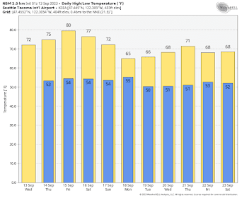
DeleteI think yesterday morning, we had some fog but did remain cloudy for most of the day here in Tacoma. Today was pleasant, sunny and low 70's for the high. Overnight lows are getting cooler, tonight is 51 expected, but I think Tacoma did hit the upper 40's a time or 3 already. As I type this at 7:40Pm on the 13th of Sept, the sun has almost totally set, the street light has turned on a couple of minutes ago and dusk is upon us.
ReplyDeleteI'd say this is mostly what we should expect for mid September to be honest and as you say, next week in the 60's more or less on target for averages. I had to run the AC late afternoon as the sun had been streaming into my front windshield so the AC and both back windows partially opened to expel the heat build up when I ran to the store.
The current Weather Channel forecast (9/14, 8:30AM) contradicts the model prediction shown in the graphic. No precipitation is forecast for the Bellingham area for the foreseeable future. It looks increasingly likely that the 2022-2023 water year (Oct 1 - Sep 30) at BLI will be the driest in its 75-year (74 water year) period of record.
ReplyDeleteYou are not correct. The latest Weather Channel forecast shows rain for Bellingham. Please try again and be make sure you have the correct location.
Delete