Yesterday's high at SeaTac was 84F and today much of the central and south Sound reached the upper 70s to low 80sF.
But with a significant shift towards a more autumn-like pattern this week and a rapidly weakening sun, there is a good chance that SeaTac Airport and much of Puget Sound country will not see another eighty-degree day until next spring.
Take a look at the visible satellite image this afternoon (below). The Pacific Ocean does not have a summertime look! A weak, but broad, frontal system is offshore and some of its clouds are moving in tonight. A more potent cyclone and front is now over the Gulf of Alaska, and we will get a taste of its southern portions in a few days.
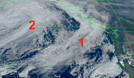
The most notable feature in this morning's satellite image was a plume of smoke from a few small, lightning-caused fires near Hurricane Ridge in the Olympic Peninsula. Considering its location and its natural origin, the Park Service is letting it run its course.


.png)
What about rain?
We are likely to get some.
The first band will be relatively weak, with the total through 5 PM Monday only bringing light showers to western WA, but more meaningful precipitation over southwest BC. Cooler temperatures and high humidity will knock back the Olympic Mountain fires.
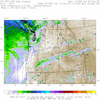
The second, more potent system will come in on Tuesday/Wednesday morning, with real rain over NW Washington and southwest BC.

.png) |
As a result of bountiful California rain and cooler-than-normal temperatures, wildfires are well below normal this year in CA (and were also below normal last year).
Want the proof? Here are the last statistics from CALFIRE, the official fire agency in California. The media likes to paint an "end of world" picture about wildfires, but the truth is different.


It's interesting. I wonder if Environment Canada has access to any forecasting tools whatsoever. They were forecasting none of this upcoming rain. Forecasts were for clear sky and sun for 7 straight days. It wasn't until yesterday that they revised. It's as if they just read Cliff's forecast and copy him.
ReplyDeleteIt will be interesting to watch IWV forecast charts as they change in the next week - otherwise September ends with a bang And a whimper.
ReplyDeleteThe above model prediction looks much more realistic for the Bellingham area than that shown in the post 5 days ago and corresponds well with the current Weather Channel/Wunderground forecast. Fortunately, the last temp in the 80s at my location in Bellingham was more than 3 weeks ago when the daily max temp was 83.9F on 8/27.
ReplyDeleteWhy is it that the first promises of rain in early fall usually get downgraded and/or underperform? About 3 days ago "they" were predicting considerable rain for the North sound, but now it has been reduced... It happens about every year.
ReplyDeleteThe first few coldfronts of the fall normally come in weak as they break down the high pressures over the interior, after that the rains are on and storms get stronger, normal transition period for fall. Was checking the temperatures near the artic circle yesterday and they are mostly below freezing and some were in the teens so the storms will start to pick up strength
DeleteToo much rain in southern CA? Yes, well- consider this a complaint about too many consecutive dry summers in Western Washington.
ReplyDeleteWhat do you mean consecutive dry summers here? We ALWAYS have very dry summers here. We have some of the driest summers in the US. This is NORMAL for this region.
DeleteFirst impressions I guess. When I moved out here in the early 70's it seems we must have had a run of wet summers. Seemed like the 3rd week of August was usually a washout and I got rained out of every 3rd or 4th hike. It might also be that Gig Harbor where I moved is somewhat wetter than Bothell where I am now...
Delete