October 31, 2023

The November Precipitation Switch

One of the most remarkable aspects of Northwest weather is the rapid turn-on of significant precipitation in November.

October is often a decent month, with substantial sunshine.  But not November.   The master switch really gets pulled sometime during the first week of the month, with the third week often being the wettest of the entire year.

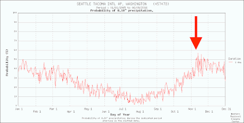
To illustrate this, here are the climatological probabilities of getting a tenth of an inch of rain in a day in Seattle.  The probabilities sneak up in October, but there is a huge jump during the middle weeks of November (see red arrow)


This year will not disappoint rain lovers and ducks.

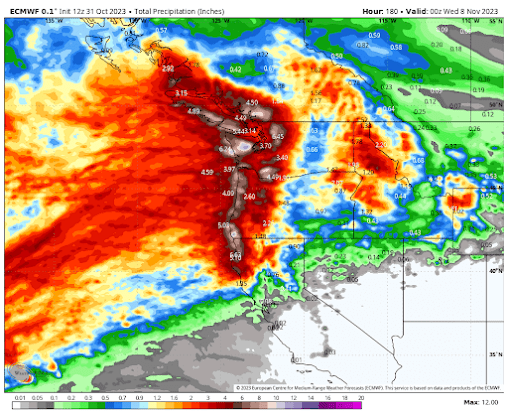
The highly skillful European Center model predicts substantial rainfall through November 7th....some locations (mountain slopes) will enjoy as much as 8 inches of rain.

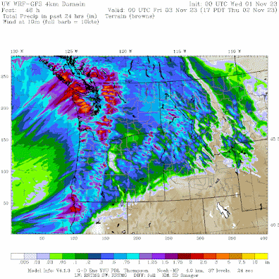
The higher resolution WRF model describes the first pulse of rain late Wednesday and into Thursday, with substantial soakings in the Olympics and Cascades.   Even eastern Washington gets notable rain.


This rainy period will be associated with a moderate atmosphere river....a plume of moisture out of the tropics/subtropics...that will be aimed directly at our region (see the forecast for tomorrow at 5 PM of the amount of atmospheric water vapor in a vertical column of air).

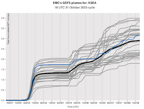
To evaluate the confidence in this forecast, meteorologists review ensembles of many forecasts.  For Seattle, the National Weather Service global ensemble shows a rapid precipitation turn-on tomorrow after roughly 6 PM, a wet night following, and then lots of rain over the subsequent week.  All the ensemble forecasts indicate wet conditions....you can take this prediction to the bank!

Many Northwest Rivers are now experiencing below-normal flows.  This will not be the case in one week.  Reservoirs should start to fill 

Furthermore, we have been experiencing far cooler-than-normal temperatures over the past several days.  The cold period will end with the precipitation, as warm moist air sweeps into the region.

October 29, 2023

The Humidity Inside Our Homes is as Low as the Sahara Desert

Shocking but true.....the relative humidity inside most homes, apartments, and businesses in our region is now as low as the Sahara Desert.


According to a number of references, the average relative humidity near the surface in the Sahara is typically around 25%.


So how close do we come to these dry conditions?

The wonderful PurpleAir network reports inside and outside humidity.  Considering Seattle, here are the current outside relative humidities from this network.  A lot around 60%, which is relatively low for this time of the year.   


But now take a look at the indoor relative humidity from the same network.  Wow.
Many in the 20s, some in the low 20s.    No wonder my skin is cracking!


But let's not be too Seattle-centric.  How about the eastern slopes of the Cascades?

The outside relative humidities vary but are generally around 50%.


But indoor values are generally in the 20s, some in the teens.


So if you had a trip to the Sahara planned to enjoy some nice dry air, you can cancel your trip.    Indoor conditions in the Northwest are just as dry.

But why is the air so dry inside now and during much of the winter?   

It doesn't have much to do with the humidity of the outside air.    Even if the air outside was totally saturated (100% relative humidity), our air would still be dry inside.

But it does have something to do with temperature, and particularly the DIFFERENCE in temperatures between inside and outside air.

I don't think any of you have missed the fact that it is unusually cold outside, particularly during recent mornings.  Take a look at the low temperatures this morning (see below).

A lot of temperatures in the 20s F in the west and teens to the east.  30s near the water.


So heating systems have to bring temperatures up to 30-40F to make us comfortable.

But that has a big impact on relative humidity!  

Relative humidity is the ratio of the amount of water vapor in the air divided by the maximum amount the air can contain at that temperature.

So if a sample of air contains 50% of the maximum amount of water vapor it could hold at that temperature, the relative humidity is 50%.

The big issue is that the amount of water vapor that air can hold goes up very, very quickly with temperature (see the plot below).


Buildings are leaky with cold outside air continuously entering through gaps and cracks, and then being warmed up by our heating systems.

So imagine if the cold outside air is totally saturated (100% relative humidity) and then infiltrates into your house or apartment.   The amount of water vapor in the air (or more exactly, water vapor per unit volume) does not change much.  

But the amount of water vapor the air can hold or contain has gone up a LOT because it is now much warmer.

Thus, relative humidity plummets.   To say it another way, the numerator (the amount of moisture in the air) says the same, but the denominator (the amount of water vapor the air can hold) has gone up a lot.

               Relative humidity= amount of water vapor in a sample of air
                                               max amount of water vapor the air can hold at that temp.

Thus, relative humidity plummets.


October 26, 2023

First Frost in the Northwest

A number of locations in the Northwest had their first frost this morning or yesterday morning.  Frost season is here.

Below are the low temperatures today for all locations that dropped to 33F or below.  Keep in mind these temperatures are for the standard height of 2 meters (roughly 6 ft) above the ground.  During the cool season, temperatures often get colder towards the surface.  

Several locations in western Washington dropped in the upper 20s, as did observing locations over the Columbia Basin.    But if you want real cold, Montana should be your destination;  some temperatures bottomed out below 0F!


You will notice that Northwest Washington was particularly cold this morning.  Want to know why?

Because the skies cleared overnight in that area, allowing the surface to effectively emit infrared radiation to space (see visible satellite image this morning).

Visible satellite image around  9 AM Thursday

So what does the next week look like?  Before I show you the predicted temperatures, let me remind you that surface temperatures (where frost is found!) can be several degrees below reported or forecast surface air temperatures, which are valid at 2-meter above the surface.

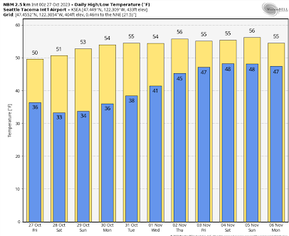
For SeaTac, temperatures are predicted to drop around 33F on Saturday morning.  Frost is possible at the Airport!  


But for locations a bit away from the water and less urbanized, frost is a near certainty.   For example, check out Olympia  Airport.  Lows down to 27F.  Frosty!


Eastern Washington?    In Yakima there will be a hard freeze with temperatures getting down to the low twenties on several days.


As noted before, the low temperatures depend on distance to water, urbanization, and elevation, with valleys being colder.  To illustrate this pattern, below is a very high-resolution prediction of the 2-meter temperatures on Saturday morning at 8 AM from the high-resolution UW modeling system for western Washington.  

Below-freezing temperatures are indicated by the blush and purple colors. Warmer near the water and cooler in river valleys.  Very cold in the Cascades.

You might ask whether this frosty period in late October is unusual.

For SeaTac Airport, the average day of the first freeze is November 14, so if we do get some frost at the airport during the next few days, it will be about two weeks early.  In contrast, for Olympia, the average first frost date is October 6 so freezing temperatures are late there.

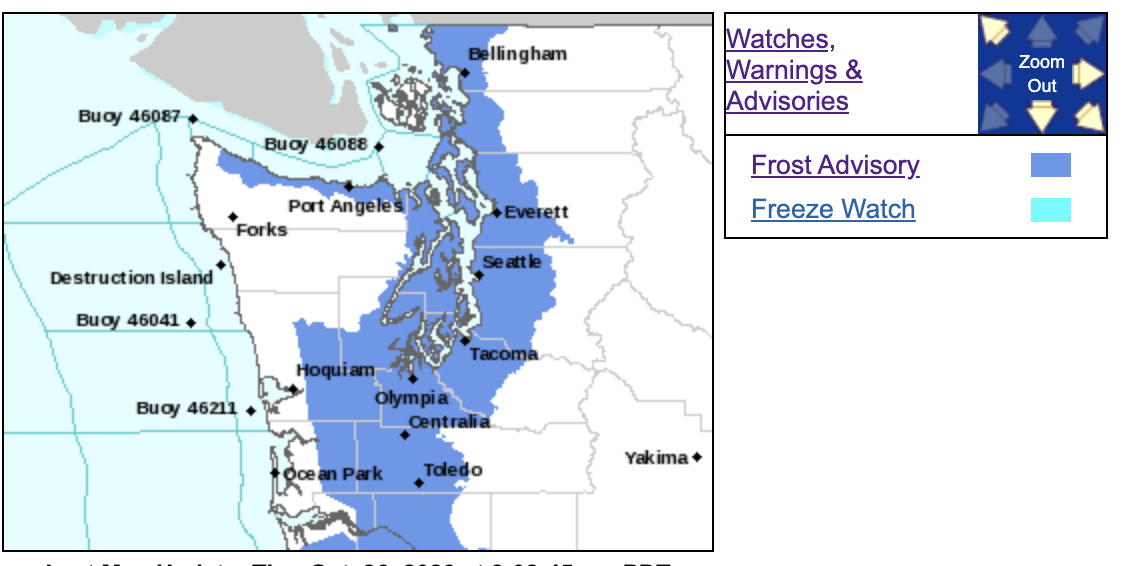
Finally, let me note that the National Weather Service has both a frost advisory and a freeze watch out.



October 24, 2023

Early Heavy Snow for the North Cascades

 The mountains of Washington State will get an early blast of heavy snowfall during the next few days, with a particularly heavy snow dump (1-2 feet) over the eastern slopes of the  Cascades.  

If this was a few months later, I would be warning about snowfall over the lowlands of western Washington, but this IS mid-October.

Let me start by showing you the snowfall prediction from the NOAA/NWS National Blend of Models, the guidance heavily used by local National Weather Service forecasters.

The snowfall total through Wednesday at 5 PM is impressive and crazy high over and to the east of the North Cascades---as high as 1.5-2 feet on some of the highest terrain.  Virtually all of Cascades and Olympics above 2500 ft will get significant snow.  Stevens Pass would be treacherous.


What about the UW WRF weather prediction model?  The high-resolution (4-km grid spacing) domain also produces heavy snow, but shifts the snow epicenter down to the central Cascades. (see below).  Snoqualmie and Stevens passes would both get significant snow.  Leavenworth as well.


So why such heavy early-season snow?   First, much cooler air will be moving into the region as Arctic air shifts southward on Tuesday and Wednesday.   

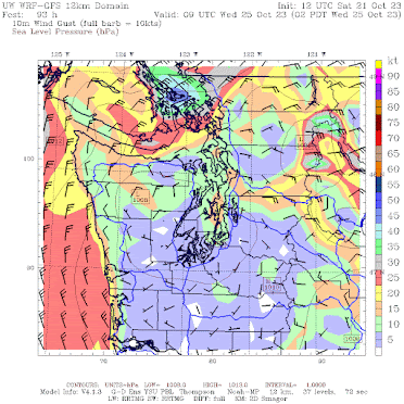
But there is more:  a potent low-pressure system will be moving to the Washington coast as well.   To understand the complex geometry of the predicted weather, below is a forecast of sea level pressure, surface winds, and low-level temperatures (color shading) for 2 AM Wednesday morning.

The low center is centered near Hoquiam.  Very cold air has moved into southern BC, Alberta, and western Montana.  And with the cold air is high pressure (cold air is more dense/heavy than warm air).


But why is the snowfall so large on the eastern side of the Cascades?

Because of strong winds from the east that are forced to rise by the eastern slopes of the Cascades.  And rising air is associated with precipitation.  

To illustrate the situation, consider the winds and heights (like pressure) at around 5000 ft (850 hPa pressure) at 2 AM Wednesday (see below).  Strong easterly flow is predicted... flow that is headed straight up the Cascades.


The result?  Lots of snow.

Both the Seattle and Spokane offices have put out special snow warnings (check below).

Seattle

Spokane

Be prepared for winter driving if you are crossing the Cascades on Wednesday!
____________________
Announcement

I will have a special zoom session for Patreon supporters on Saturday, October 28, at 10 AM.


October 21, 2023

The First Major Arctic Air Blast of the Season

A major, and early, blast of Arctic air will move into the Pacific Northwest during the next few days.

Snow will move into the Cascades and large areas to the east.  In a few locations east of the Rockies temperatures will drop into the single digits.

Let me illustrate this frigid turn of affairs by showing you the predicted surface air temperatures over the next week.  

I warn you....you will be thinking about a nice cup of hot chocolate before you read very far.

The situation at 5 AM Sunday, shows really cold air (white and purple colors) up in the Arctic, where it belongs.  Temperatures have been steadily cooling over northern Canada and Alaska during the past month.


But by Tuesday morning, the cold air will surge southward into British Columbia and Alberta.


And Thursday morning, Arctic air will spread over the entire Northwest, except for most of western Washington and Oregon.  The chilly exception is Bellingham and its vicinity.


And that cold air will remain in place at least through Saturday morning (see below).


Northwest Washington including Bellingham and San Juan Island will be hit by this Arctic Express as cold air surges southwestward through the Fraser River Valley.  Below are the forecast winds for 2 AM Wednesday.  Gusts to 40-50 kts, with temperatures in the 30s!  Wow.  This is going to be quite the cold shock.


Temperatures in Montana and North Dakota will be particularly impressive with lows at Minot, ND dropping to around 12F and temperatures never getting above freezing. Some Montana locations will cool below 10F.


Let's be clear, the cold hitting the region will be dangerous for homeless individuals, who will not be prepared for the temperatures.  And you should never forget that cold temperatures kill far more individuals than heat waves.  You won't hear about this in the media, but it is absolutely true.

Some moisture will accompany the approaching Arctic air, with significant early snow as a result.  Below is the forecast snow total through 11 AM Thursday.  Plenty in the Cascades.  Northern Idaho and Montana will get a light blanket of the white stuff.


In short, get ready for a substantial, if not shocking, change in the weather.  The Arctic is coming to us in the Northwest.

October 19, 2023

The Mid-October Temperature Transition

One of the interesting aspects of Northwest weather is the mid-October temperature transition to cooler temperatures, and this year will not be an exception.

Below is the latest forecast of temperatures at Seattle from the National Weather Service GEFS ensemble of many forecasts, with the black line showing their average (generally a very good forecast).  

Warm temperatures today, followed by a plummet towards highs only in the mid-50s for the next week.

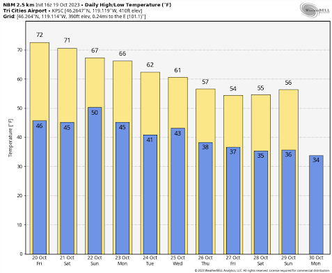
Another skillful forecast system--the National Blend of Models-- is also going for high temperatures only reaching around 55F for days at a time!


A similar story in the Tri-Cities:


This cool-down is right on schedule.  I have always been fascinated by the rapid fall transition in our region.

Let me show you the climatology for Seattle during the autumn (below). The red line shows the record daily high temperatures, and the blue shows the record lows.  The average temperature range by the brown band.  The vertical blue line is today.

Before today, high temperatures have reached highs of 80F or more, but not after this date.  The intensity of the sun is getting weaker and clouds are increasing too much. 


This date also represents the transition to the potential of below-freezing temperatures, which never occurred earlier in the fall.

And another transition looms in one month--after mid-November serious cold-air outbreaks and snow can hit western Washington.

In short..time to get your sweaters out....


October 17, 2023

Extreme Precipitation Variations this Autumn

 The Pacific Northwest is an area of meteorological extremes, particularly for precipitation.

To illustrate, check out the regional precipitation totals for September 1 to October 17 for this year (see below).    Quite amazing.

On the windward (southwest) slopes of the Olympics there was OVER TWENTY inches of rain.  In fact, nearly two feet at one location.  But a few miles away on the leeward (northeast) side of the barrier near Sequim only 0.83 inches.


Puget Sound received about 4 inches (lower over the north Sound than the south Sound), with precipitation increasing into the Cascades.   Large areas of the Columbia Basin, in the rain shadow of the Cascades, had less than a quarter inch.

Bottom line: there was a much as HUNDRED FOLD difference of rainfall between the Columbia Basin and the slopes of the Olympics.  

That is impressive.

The craziest contrasts have to be over the northeast side of the Olympics (see a plot of precipitation for the same period below).

One location just south of Port Townsend had only about 0.37 inches and and lighthouse near Sequim only received 0.56 inches.    About 30 miles away to the southwest, there was 23.90 inches. 


As I have discussed in previous blogs, such precipitation contrasts are mainly forced by terrain, with strong upslope flow on the windward (southwest) side of the Olympics producing bountiful precipitation, while downslope flow on the northeast leeward side results in extreme drying (see schematic)


No wonder folks like retiring around Sequim, from Port Townsend to Port Angeles.


October 14, 2023

A Dramatic Annular Eclipse over the Northwest

The annual eclipse this morning was quite a treat...even here in Seattle where only 80% of the sun's disk was covered by the moon.

Viewable through a thin veil of clouds over Puget Sound country, the sun looked like a crescent moon around 9:10 AM (see a wonderful photo by my UW colleague Alex Anderson-Frey).


It was not a little eerie.  

Solar radiation is measured on the top of the roof of my building and I plotted the solar radiation over time this morning (see plot below, time increases to the left).  See below.

Solar radiation increased rapidly from 8 to 8:20 AM PDT (1500 to 1520 using a 24-h clock), then started to decline rapidly as the moon covered the sun!  

Around 9:10-9:15 AM the solar radiation was at its weakest-- a huge drop.

And then, as the moon moved off the sun, the solar radiation rapidly increased.


But if you really want to see how dramatic the loss of solar radiation was you need to check out a loop of the visible satellite imagery (see below).  Look closely and you will see the shadow of the moon move through from west to east.

Finally, the loss of solar heating was obvious in the temperature plot of the UW (shown below).   The temperature rose before 8:45 AM and then declined over the next hour, subsequently rebounding around 10 AM as full sun was restored.


In summary, a dramatic, interesting astronomical/meteorological event.  And let me end with a superb image taken in the center of the eclipse in southern Oregon (by Deena Stevens)


October 13, 2023

Hamas Rally at the University of Washington

Yesterday, a pro-Hamas rally took place on Red Square at the University of Washington, with the sounds spreading across a large area of the UW.   It reverberated in my office.

Speakers at this gathering supported the violent actions of Hamas and called for the destruction of the State of Israel.  Their advertisement for the rally celebrates a death-dealing Hamas paraglider:

As many of you know, I am a great supporter of freedom of speech, an essential part of American democracy.  But that does not include calling for violence and the deaths of others; thus, what happened at the UW was well across the line and totally wrong.

A young Jewish student was in tears as she asked a UW administrator to stop the Hamas rally.  Her statement was heart-rending:  "they want to kill ME."   And she was right.

There is a lot of talk about safe spaces on university campuses.  For Jewish students, there was no safe space on the UW campus yesterday.  Many were afraid.  Sitting in my office hearing the proceeding I was highly disturbed.

Let us be clear, the actions of Hamas were barbaric and immoral. 

 There is no excuse for their actions.  None. 

Over a thousand people were slaughtered.  Babies had their heads cut off.  Families were torched.  Pregnant women were cut open.  Celebrants at a music festival were cut down.  Thousands of rockets were sent across Israel to maim and kill.  Hundreds of Israelis were taken as hostages and will probably be killed. Nearly two dozen American visitors were slaughtered.

It is the same kind of barbarism done by the Nazis during the second world war.  Like the pogroms of Russia in which Jewish families were slaughtered indiscriminately.

No nation in the world would tolerate such an attack on its people and Israel needs to strong backing of the American people to stand up against such barbarism.

Super Bird Migration on Thursday Morning

The only creatures that watch the sky more carefully than meteorologists are...well... birds.

Our feathered friends spotted a perfect meteorological situation for their flights south and headed into the sky in great numbers on Thursday morning.  

Nothing shows up better on weather radar than a nice plump bird.  To illustrate, below is the radar image at 3:30 AM Thursday morning that combines all Northwest radars, with the shaded area showing radar returns (greens show more reflected radar signal than blue).    

Normally, radar shows mainly precipitation, but none was falling at this time.  This time it was birds, all birds.

From the intensity of the radar echoes there were a LOT of birds in the air.  Note that birds don't like to fly too far offshore.  

And don't think there were no birds over southern Oregon.  No low-level radar coverage there.


The national bird migration website, BirdCast, makes intensive use of weather radar to track birds.  Their analysis at 2:40 AM on Thursday morning shows the intense migration southward along the West Coast.


The migration was less on Wednesday morning and this morning.    

But why?  Why did the birds decide that Thursday morning was such a good time to get some southward mileage in?

First, birds prefer not to fly in the rain, and who would blame them for such a preference?  And earlier this week it was raining.

Second, they like having a tailwind...yes, literally a tailwind.  And they hate a headwind.

Let me show you the wind situation at approximately 5000 ft (850 hPa) at two times:  when the birds mainly stayed on the ground and later when they took to the skies.

On Wednesday morning at 2 AM, a low center was found near our coast and moderate southerly (from the south) winds were found over western Washington and Oregon.  Winds are blowing in the wrong direction for the migration south!


But on Thursday morning, the low center is gone and the winds are weak from the north over some of western Washington.   A bit warmer.  No rain.   Bird migration paradise.

During the next week, a series of storms will be moving through so the birds will have to keep watching the sky.


Was Yesterday's Forecast a Success?

 Time for a little "inside baseball" on weather forecasting, particularly regarding yesterday's wind event. There were a few c...