If you live along the Washington coast or in NW Washington, I would charge up all your electronics during the next 6 hours.... a decent blow will occur overnight.
And portions of Seattle might get a piece of it.
No....this will not be another Columbus Storm, but winds will gust to 40-60 mph in locations, and early-season storms always have enhanced impacts since leaves are still on trees.
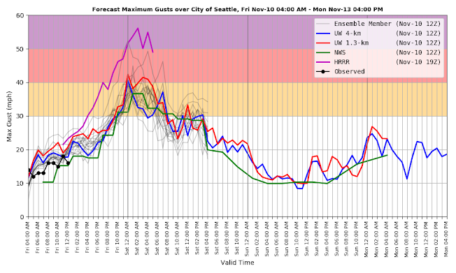
Consider Seattle, where the UW WindWatch application (supported by Seattle CityLight) provides the most high-tech wind forecast in the region.
All models (the individual lines) predict a rapid acceleration this evening (Friday), with peak winds of at least 30 mph. But some of the best are stronger (e.g., the NOAA HRRR model and UW high-resolution prediction), with winds gusting to 40-55 mph.
That suggests power outages.
What is going on? A Pacific front will move through, with associated low pressure passing to our north. This will cause a substantial increase in the north-south pressure difference, which in turn will accelerate the winds from the south.
But there is more....the strong winds will interact with our mountains, producing wind "hot spots."
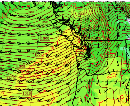
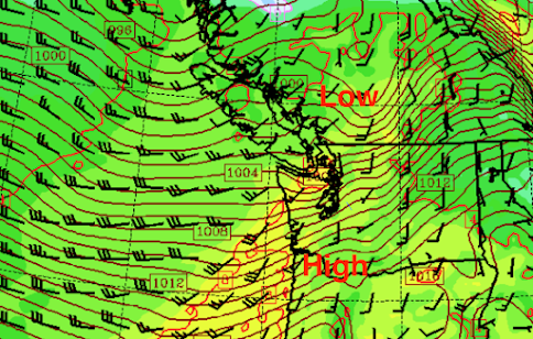
Let me illustrate this with wind predictions from the UW ultra-high resolution modeling system. First, I will present the sea level pressure pattern (isobars) with solid lines and winds shown by the wind barbs.
At 10 PM, a low will move into BC with large changes in pressure to its south.
By 1 AM Saturday, a very large pressure gradient will exist over western Washington.
The implications for local winds are substantial.
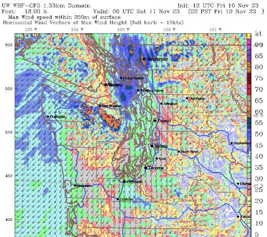
Let me show you the predictions of maximum surface wind gusts from the UW high-resolution system.
At 10 PM tonight, the winds will be howling over NW Washington and quite strong along the coast (gusts to 50 mph and more). Even stronger winds will occur just downstream from the crests of the Olympics, where hurricane-force gusts are predicted. Puget Sound will just be blustery at this point.
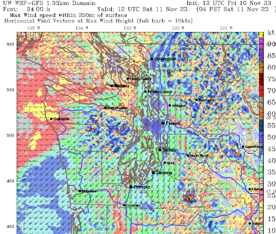
But a few hours later (4 AM is shown below) northern Puget Sound country will be rocking (blue colors), as will the higher terrain in the Cascades.
Good timing in a way. The power may go out while you are asleep.
So my advice to all of you from Seattle northward.....get your gear charged up tonight.
Eastern Washington? It will experience strong winds a few hours later, with gusts to 30-40 mph (see predicted winds at 7 AM Saturday below).
Ivar's Mukilteo Landing Dinner and Talk on December 4
I will be doing a book signing and lecture, accompanied by a special dinner, on December 4, at the very special Ivar's Mukilteo Landing Restaurant. The event is limited to 50. More information and registration form is here:


A few aging power poles were just replaced on my street. Begs the question why aren't we undergrounding these lines?
ReplyDeleteCost.
DeleteWhen I search for information from utilities, I see numbers ranging from 3x to 20X as expensive for underground vs overhead powerlines. One example:
https://www.prpa.org/transmission/types/
It's extremely costly to underground existing lines. And guess where the cost goes?
DeleteBecause it's way more expensive to install, and somewhat more expensive to maintain in the sense that any faults are harder to find and repair when the cable's underground. On the other hand there should be fewer faults to find, what with underground tree limbs not being a thing....
ReplyDeleteThese sorts of winds enter the wide-open valleys of the mountains and gain velocity as the canyon narrows. Tops bend back-and-forth and sometimes snap off and land spear-like, piercing the soil but upside down. It is an impressive sight. More damaging is when the entire tree topples and a hole appears where the root-ball was. Many trees can fall and crisscross like pickup sticks. Makes lots of work for the log-out crews to open trails.
ReplyDeleteWind gusts at Ellensburg (KELN) set to top out at 37 mph.
Those big winds definitely occurred on the hills just north of the Olympics near Joyce, my folks live on the hill north of Lake Cresent and some gusts were in the 70s from the south.
ReplyDeleteIt got more than a little breezy in the extreme southern edge of Thurston County, but few outages happened in this area. I just checked the PSE site and most of the outages are fixed already. Overnight, I heard the rain much more than I heard the wind. Had I not read about this beforehand, I'm sure I'd have slept right through it
ReplyDelete