The end of January -midway into the western U.S. water season--is a good time to evaluate potential water resources for the upcoming summer.
There had been some concern that an El Nino winter would result in drought conditions for some and flooding for others. Fortunately, such fears do not appear to be realized.

Let us begin by reviewing the all-important reservoir levels in California, whose low values two years ago were a cause of great concern.
As shown below, California's reservoir levels are in excellent shape and generally well above normal. The largest and most important reservoirs (Shasta and Oroville) are at 121 and 131% of normal, respectively. Other reservoirs are also in good shape.

Moving north, what about the water levels behind the all-important Grand Coulee Dam in Washington State? As shown below, water leves are above normal. Good for power generation and fish.

Seattle's reservoir levels?
In December they had fallen substantially below normal, but four days ago (Jan 22, shown below) were just below normal. Recent rains have brought reservoir levels up to nearly normal. With the certainty of substantial rains during the next weeks and a near-normal snowpack for the relevant mountain drainages, Seattle should be in good shape waterwise for this summer.

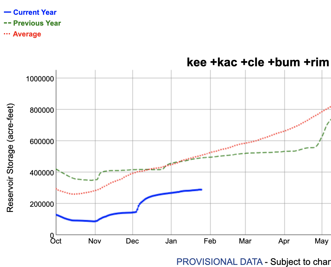
Over Oregon (below), with the entire state averaging a bit over 100%.

Washington (below) is currently a bit below normal, with the critical Cascade watersheds around 80%-- a far better situation than a month ago. The Yakima drainage is at 91%.

The next week should be very wet along the West Coast. First, the Pacific Northwest and British Columbia will be hit by a series of moderate atmospheric rivers (see the European Center total precipitation forecast through Monday afternoon below.)


Finally, with El Nino starting to weaken rapidly, its impacts should begin to fade during the upcoming months.


It's interesting to see the current cpc outlook for this summer is well above normal temps and below normal precipitation for the PNW and much of the west, so it's a good thing we're getting the rain and Mt snow now.
ReplyDeleteIt will be interesting to see whether long - range forecasters continue to employ the ENSO data in order to determine the relative impact of El Nino and La Nina winters.
ReplyDelete75% of the snow on the ground in Kelowna BC is now gone. Green grass visible again. The rain keeps coming and cleaning up this mess
ReplyDeleteThe US Drought Monitor has WA drier. https://droughtmonitor.unl.edu/CurrentMap/StateDroughtMonitor.aspx
ReplyDeleteClive...unfortunately, the Drought Monitor is subjective and unreliable..cliff
DeleteYour concern about the water situation for the Yakima basin area is certainly valid. The two main reservoirs for this area, and for all western areas, is, #1, the amount of current reservoir storage, and #2 which is probably more important, the amount of snow water storage that feeds into the reservoirs. Both are currently below normal in the Yakima Basin. The current rain pattern may increase the reservoir storage but probably at the expense of the snow water reservoir as substantial melting will likely occur over the next several days. We will need to hope this snow water reservoir improves over the coming months and that the outlook for a warm, dry spring and summer does not seriously verify.
ReplyDeleteThe good news is that it's going to be wet for the next few days. The bad news is it's going to be warm and the rain is going to erode some snowpack.
ReplyDeleteThe snowpack forecast is below average for Grand Coulee or upper Columbia this year, and that is why they didn't use more water for power generation during the recent cold snap. It costed something like $120 million for them to purchase power from other sources to meet the obligated electric load to customers, rather than using up more of the water but running risks later in the season
ReplyDeleteCliff--what about the 45% of normal snowpack for the Olympics--this seems concerning
ReplyDeleteThis is not serious as it looks....far less demand on Olympic snowpack. And with plenty of rain, reservoirs are in good shape...
DeleteCliff, aren't reservoirs typically in good shape this time of year? The challenge is keeping them that way through the dry season, and we need snowpack for that.
ReplyDeleteIt's great to see all this rain coming in, but the warm weather is still a concern. Snow level today is 8000 feet - great for reservoirs, not so much for snowpack.
Your precipitation forecast was correct, but the Washington snowpack has *declined*. Welcome to climate change.
ReplyDeletehttps://www.wcc.nrcs.usda.gov/ftpref/data/water/wcs/gis/maps/wa_swepctnormal_update.pdf
As a farmer, I think you are missing some of the parts of drought. Long term disruptions in soil moisture take more than a couple of reservoir filling rain storms to counter. What is the elevation of the snowpack line? Move up a few hundred feet and you lose a lot of moisture storage. The Olympic mountains are now at 29% normal snowpack. This is a deeper issue than you seem to speak to through the lense of current weather.
ReplyDelete