The U.S. West Coast is experiencing a very wet period and this pluvial bounty is not ending soon.
Dramatically, measures of water vapor approaching our coast are impressive.
To illustrate, consider the water vapor imagery from the NOAA GOES-West satellite on Saturday afternoon (see below).
I rarely show such imagery on this blog and it is virtually never presented by the media. Where it is white, there is a lot of water vapor in the mid to upper troposphere (roughly 18,000 to 35,000 ft). The image below shows the entire West Coast engulfed in H2O.
Expect little change this week. Currents of water vapor, generally from the subtropics and tropics, are commonly called "atmospheric rivers" and several of them will be headed for the western U.S. this week.
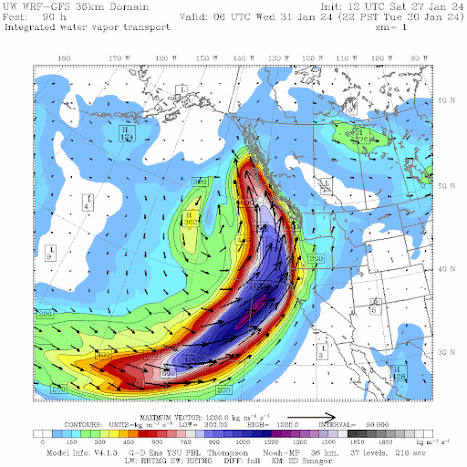
One of the best ways to identify a potent atmosphere river is to plot "water vapor transport", which is essentially the moisture (water vapor) content of the atmosphere times the associated wind speed. Essentially a measure of how much water vapor is being moved about by the winds.
The predicted atmospheric river and associated water vapor transport this evening (Sunday) are impressive (blue colors), with the most potent influx of water into British Columbia.
But if you REALLY want to be impressed, check out the atmosphere river prediction for Tuesday evening. Just wow. And this one is headed for northern California and the Pacific Northwest.
The predicted 48-h precipitation totals ending Friday morning are impressive over northern California and British Columbia gets a big piece of it as well:
Many West Coast rivers will be running high. In fact, they are already running high with numerous NW rivers much above normal on Saturday (see below).
Stay dry,


Rain train, pineapple express, atmospheric river, water bus, precipitation Nation, heaven47, steam wagon, hydrogen carriage, unfroze hose, damp Chute, water cannon, mist shift
ReplyDeleteNot much of that H2O making it east of the Cascade Crest. Just as well, we don't need rain-on-snow event.
ReplyDeleteThere's so much water flooding uselessly into the sea. I wish we had more reservoir capacity in this state
ReplyDeleteIn the US we have built many more dams and reservoirs than we need. And in the Pacific Northwest every reservoir represents lost salmon habitat.
DeleteRichard...we very much need the dams and reservoirs for power generation. Why is salmon habit such a priorty? Is anyone suffering from insufficient salmon?..cliff
DeleteSalmon habitat is priority because of treaty rights and the Endangered Species Act.
DeleteDripper shipper
ReplyDeleteChris W: Give yourself 100 points.
DeleteThe nutrient transport of rivers feeds ocean life and flooding events like these are feasts in the making. Those rivers are brown for a reason: it's not just water. The amount of "stuff" a river moves is downright awesome. Locking to much of it up in damns and reservoirs is essentially cutting part of the food supply to the lowest (and most essential) end of the oceanic food chain.
ReplyDeleteDon't you think that a free flowing water shed backed by a more thoughtful water conservation plan might be a better course to steer? I think it will be important for the regeneration and future health for our oceans.
Hit 70 degrees up in Mount Vernon. I thought I was back in Hawaii.
ReplyDeleteExtraordinary weather in Bellingham last night. The temperature at my location rose from the mid 50s at just before 5PM to 69.5F at 7:30PM. By 10PM the temperature had dropped to 65F and winds were gusting nearly 50mph. The only time I've experienced such warm and windy weather in Bellingham was during the remarkable windstorm of August 29, 2015.
ReplyDeleteCliff, can you explain the general atmospheric conditions that set up the common “narrow cold frontal rain band” that is so common with atmospheric rivers?
ReplyDelete