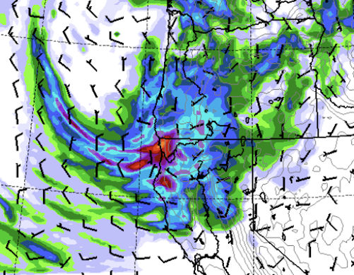
The current precipitation forecast for precipitation over northwest Washington over the next few days is stunning.....particularly, what will hit the ground tonight.
Many daily records will fall.
Consider the accumulated precipitation through 5 PM on Saturday.
Unbelievable. Large areas of northwest Washington will receive more than two inches, some 3-6 inches.
Most of this will fall overnight. Even more will fall on Monday, with the accumulated totals through 5 AM Tuesday shown below. There will be localized flooding around Bellingham.
As noted in previous blogs, the cause of this wet period is a record-breakingly deep closed low/trough aloft (see graphic below for 5 PM today (Friday) at 500 hPa, about 18,000 ft).
This drenching rain will end the wildfire season over the NW Washington area. But let us not forget southern Oregon and northwest California, which will get very wet as well.
Finally, I have been hard on the Seattle Times when they provided inaccurate and exaggerated information about heat, drought, and climate change. So let me acknowledge that they finally did a story that highlights cold and rain.😀


Can you go ahead and tell it not to rain tomorrow between 11:00 a.m. and 5:00 p.m. For our charity motorcycle ride?
ReplyDeleteOn a serious note, excellent write-up
So, the big question - is summer over? Does the long dark start today? I was so hoping to get at least one tomato out of the garden this year....
ReplyDeleteAs per the movie JAWS, "We're going to need a bigger boat." As for BLI - chuckle; always one of the driest spots in Whatcom County. But - where it comes to summer plans, bummer. I have an exterior door to refinish. Presume we'll still have some kind of 'indian summer' ahead.
ReplyDeleteDr. Mass, correct me if I'm wrong, but official forest fire season begins August 1st in Washington state, so would this be the shortest forest fire season on record?
ReplyDeleteEven though I have work to do on my car that needs good weather, thank you to that entrenched low for giving the finger to this year's wildfires.
ReplyDeleteDefinitely feels like fall this morning. I had .31 inches rain in Okanogan. Huge soaker for us this time of year as that is our monthly average in one storm. Still coming down looks to come down all day. If we get .5 it will be sweet and fires here will be out, but we will dry those dry grasses again for sure. My question is how the drought monitor will react to this. My guess won't shrink the drought, if anything they will say persists or worsens, the opposite of common sense.
ReplyDeleteGood rains have also fallen in the northern forests east of the Cascades greatly lowering what was becoming a critical fire danger period. The southern Cascades and far eastern parts of Washington have had less rain so far and it may take another good storm to help these areas. While the northern part of western Washington got good rain, the southern Cascades not so much so far. The west side still needs to get past the critical east wind period of September into October. As Cliff has stated, the amount of rainfall on the west side forests is probably less of a factor in reducing large fire potential, than is the absence of strong or prolonged east wind periods, and east wind periods are especially critical in the southern Cascades. It looks like a warmer, drier period coming up beginning next week and if we should get into a strong or prolonged east wind period, these west side areas could still have a fire problem. I was on a project fire near Camp Grisdale in the southwestern Olympic peninsula in mid October of 1972 that started about a week after that area received nearly 10 inches of rain, but was followed by a period of east winds which quickly dried the forest out despite the lateness of the season, so it is not over yet until the fat lady sings.
ReplyDeleteWe’ve been at our.cabin near Skykomish since Monday. It’s been raining since Tuesday and since Thursday it’s been heavy. The Miller River is up about a foot and was already unseasonably high. I think that wildfire danger is over for awhile and returning fish will be happy.
ReplyDeleteCan anyone explain how Bellinghams Post Point weather station (Bellingham 3 SSW, WA) temperature record from 1895 to 2018 changed drastically on the UW’s (PNW Temperature, Precipitation, and SWE Trend Analysis Tool | Office of the Washington State Climatologist) site? A screen shot I took in March of 2023 showed an increase of +0.1 deg F per decade on annual average temperature. Today the same parameters show an increase of 0.34 deg F on the site. I know they moved it in May of 2023 to be closer to the digesters, which are an exothermic reaction.
ReplyDeleteMinimum rainfall in S. Everett...must be that rain shadow again!
ReplyDelete