On some days there are huge differences between the high and low temperatures. On other days the differences are relatively small.
Why?
Some locations in our region have big day to night swings, other places not so much.
Why do such differences occur?
Consider the temperatures during the last week at Olympia, Washington. Two days ago, the temperature rose to 85 and then declined to a frigid 49F--a 36F swing (see below), but far less today as the temperature only rose to 72.
A short distance away at Hoquiam, near the WA coast, the situation was radically different. Most days had very little temperature range (or diurnal variability) with highs around 65F and lows in the upper 50s. But one day was radically different, raging from 85 to 56. Why?
Moving east of the Cascades, Pasco in the Tri-Cities, had a day hitting 108, with a low of 63. 45F of range.
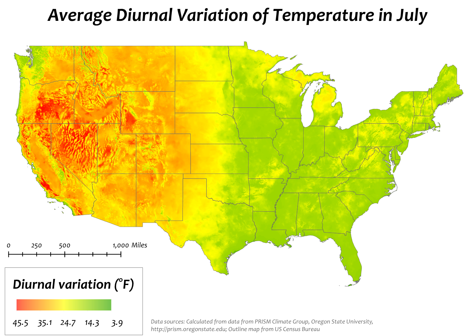
But if you REALLY want experience a concrete-cracking daily temperature change where should you go? This map for typical diurnal temperature in July gives you a hint:
Eastern Oregon is world class. Consider Baker Oregon (below). One day had a high of 109 and a low of 58. A range of 51F. Wow.
How do we explain all these differences in diurnal (daily) temperature range?
If has a lot to do with moisture--the amount of water vapor in the air. Clouds have a large impact. And so does marine influence.
Marine influence is easy. Water surfaces have a lot of thermal mass and don't change temperature quickly. Here is the Northwest, the Pacific is quite cool in summer (generally in the lower 50s), so it is hard for coastal area to warm up much during the day, and hard to get much cooler than the water at night.
Clouds also restrain diurnal temperature changes by reflecting the warming sun's rays during the day and preventing cooling at night (clouds act like blankets). During the past week, coastal areas had plenty of clouds and marine influence (see satellite image today). No wonder the temperature range was so small! But one day there was easterly (from the east) winds that prevented the marine influence---big temperature range at Hoquiam that day.
But why do eastern Oregon and much of the SW interior enjoy such a big temperature range? Yes, they are protected from the cool marine influence by the Cascades. But they have a secret weapon: dry air.
Water vapor is very, very active in the infrared part of the spectrum. It can absorb infrared radiation emitted by the warm surface and re-emit it downward to the ground. In this way it acts as an atmospheric blanket.
You think CO2 acts like an atmospheric blanket? Water vapor is even better. Desert areas are notorious for cooling off at night....contributing to a large diurnal range. You remember how it did not cool off in western Washington a few days ago when it was so humid and sticky?
There are some other factors influencing daily temperature range I could have talked about...like the urban heat island effect....but I will leave that to another time.


All of Central US laughs in day to day temp swings.
ReplyDeleteDiurnal temperature range is definitely an interesting aspect of surface weather. Though the PNW isn't known for large diurnal temp ranges, there have been a few standouts over the years. For instance, Olympia set both daily record high and record low temperatures on 3/14/2005, with a high of 67F and a low of 25F. On 3/15/1988, Astoria, OR set daily record high and low temperatures of 61F and 28F, respectively. Also on 3/15/1988, Eureka, CA set daily record high and low temperatures of 61F and 28F. These instances were almost certainly the result of unusually dry air and clear skies, and I've noticed that particularly large diurnal temperature ranges seem likeliest during early-mid spring in the PNW.
ReplyDeleteOf course, there have been much larger 24-hour temperature changes which have been recorded, but the truly exceptional ones are associated with very rapidly changing weather patterns/vigorous frontal passages and also fohn winds in the lee of mountain ranges. For example, the greatest recorded 24-hour temperature drop occurred following the passage of a strong cold front through Browning, MT on 1/23-24/1916. The temperature fell from 44F to -56F. Again in Montana, the greatest recorded 24-hour temperature increase of 103F at Loma, from -54F at 9AM on 1/14/1972 to 49F by 8AM on 1/15/1972 due to a westerly fohn, or chinook, wind displacing dry, frigid arctic air with warm, moist air from the Pacific Ocean.
I think we all know this intuitively, but I always appreciate the detail you bring to the picture! I can tell it's gonna be a dry day when the forecast high/low has a 30 degree spread.
ReplyDeleteNow a question for you Cliff, do you think here in Seattle and at Northern latitudes in general, that during the height of summer we get more solar radiation compared to places closer to the equator? I just feel when I visit places in the north the sun really drains me, and it's out of proportion what you would expect based on temperature alone.