An interesting aspect of the current weather regime is the large diurnal (daily) temperature range--the difference in temperature between the daily highs and lows. At a number of Northwest locations we have seen highs in the 80s and 90s, while temperature have plummeted at night into the lower 50s and even some 40s, with some dropping into the 30s. I am talking about surface air temperatures here, measured at roughly 2 meters. Some good examples:
Baker, Oregon--high of 90 and a low of 39F: a diurnal range of 51F!
Olympia,WA--high of 85 and low of 44: range of 41F
Or consider the Turnbull climate reference network site near Spokane that had a 51 deg temperature range today with a low of 36 and a high of 87 on Tuesday. What is really amazing is the range of surface (ground) temperature that on Tuesday jumped from 32 F to 114 F (82F!!) on Tuesday. You read that right....from frost on the ground to 114F in one day. That will crack some rocks!
Here are graphs of temperature for the last two weeks--all of which show the huge range. First, Sea-Tac, then Pasco, and finally Spokane. All have a much greater range than normal.
So why such a big range? Hint: we often observe such big daily swings during late summer and early fall.
We start with fairly warm aloft and the sun being still fairly strong....that allows warming.
We have weak offshore flow aloft...that keeps the low clouds and marine influence at bay.
We have clear or nearly clear skies...that allows good infrared radiational cooling to space--and thus good temperature falls at night.
And nights are getting longer--that gives more time for nighttime cooling. And the relatively equal time for heating and cooling at this time of the year is helpful
Put this all together and you get one big temperature range. During the winter the range is far less in general, particularly because the cloud cover reduces heating during the day and infrared cooling at night.
Now for the controversial part of this blog. There seems to be some difference in opinion whether a large temperature range is good for viniculture. Does a big range help or hurt the quality of grapes used in wine-making? Some online sources claim that such a range is good since it has the effect of producing high acid and high sugar content as the grapes' exposure to sunlight increases the ripening qualities while the sudden drop in temperature at night preserves the balance of natural acids in the grape. Others, like the book by Gladstone, claims that a narrow temperature range is good. Any wine experts read this blog? What is the correct story? I have always found the meteorology of wine making fascinating...and will climate change make eastern Washington wines even better? Perhaps in another blog.
This blog discusses current weather, weather prediction, climate issues, and current events
September 07, 2011
September 05, 2011
What is the warmest place on Earth? Warmest in the Northwest?
Perennially chilled Pacific Northwest folks are naturally interested in warmth and so I thought I might share some results of very interesting article in the Bulletin of the American Meteorological Society, which attempts to find the hottest place on earth and here in the NW. (Article is by David J. Mildrexler, Maosheng Zhao, and Steven W. Running of the University of Montana)
Do a search on the warmest place on earth and you typically get El Azizia, Libya with a record air temperature (at 2 meters) of 136F measured in 1922. Furnace Creek in Death Valley National Park comes close 134.1F. But there is another way to measure temperature--- determining the temperature of the ground (the skin temperature) from space. We can do this by measuring the amount of radiation emitted by the ground (sort of like a super ear thermometer that uses similar technology) Now this satellite approach has the advantage that it measures the temperatures everywhere and there is a good chance there is no observation at the hottest locations (who would want to live or work there!). On the negative side, this is not air temperature, which is generally less than skin temperature on hot, sunny days--sometimes a LOT less.
Anyway, these folks at U. of Montana used data from 2003-2009 from the MODIS satellite, which has a resolution of roughly 6 km (so it is probably missing the absolutely hottest points).
Ok, get your icy drink ready...here is the answer. This graphic shows you the results. The warmest location seems to be in the Lutt desert of Iran. The second graphic shows you a blow up of the temperatures and an image of that desert. Looks like hell. It is like hell.
Several places come very close....but Lutt is the winner.
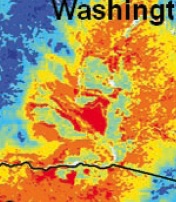
But what about the Pacific Northwest--where is the warmest ground to be found (I suspect there is going to be a stampede there in a few weeks)? Here is the graphic. The left shows the temperatures and the right the land use (click on image to expand)..
Looks to me that the warmest location is on the Hanford reservation where there is no irrigated fields. Such fields have a large impact on temperature, something you can see by comparing the temperature map (blown up version below), with a google maps satellite image (also shown). Evaporation off irrigated fields can cool temperatures down several degrees (F).
No jokes about warming from the radiation at the Hanford facility...this is not the cause. And there are a few warm locations just south of the state boundary as well. Anyway, another reason to head to the Tri-cities during the spring and fall when it gets cool on the west side. But don't try this during winter!---the lowest elevations of eastern Washington are cool and cloudy in midwinter, as cold, moist air settles into the terrain bowl in that area.
Subscribe to:
Posts (Atom)
Godzilla-Low Pressure, Heavy Rain, and Drifting Snow Ahead for the Pacific Northwest
Northwest meteorological winter is about to begin dramatically. Heavy rain and massive mountain snows are on the way. Reservoirs will b...
-
For those worried about below-normal mountain snow, your worries are over..... a major snow dump is ahead. You can also expect great skiing,...
-
A number of you have asked about this coming winter and the status of La NiƱa. Will the snowpack continue to increase? Will those worried ...