January 16, 2018

West Coast Water Supply Is In Good Shape And About to Get Much Better

There has been some recent talk of drought over the West Coast, but in reality water supplies are in good shape and about to get much better, particularly over Oregon and California.

Let's start by checking out reservoir levels.  In Seattle, the current reservoir levels (red) are well above normal (blue).  And there is plenty more rain predicted for the next few weeks.  Looks good.


The Yakima River reservoir system is critical for water supply in Eastern Washington, and as shown below, the current water storage (blue line) is way above normal (red line).

Examining the current storage in the massive California reservoir system (shown below), one notes the all reservoirs are at or above normal levels, except for Lake Oroville, which is being kept artificially low because of the severe damage of last winter.


The current U.S. drought monitors shows do drought from central CA to Washington, and dry (but not drought) conditions over southern CA and a few locations in Oregon.
Considering the precipitation departure from normal for the past 3 months, one notes wetter than normal conditions from Washington State into Montana, and slightly below normal in eastern Oregon, Nevada, and parts of California.  But modestly drier than normal conditions have occurred over northern CA and coastal Oregon.   This is about to change.


The latest weather forecast model runs indicate a very wet future from central CA to British Columbia.  The 15-day totals from the National Weather Service GFS model has 5-10 inches over much of the Coasts, with 10-15 inches over the Sierra Nevada and the coastal mountains of northern CA and southern Oregon.

And all this precipitation will include immense snowfalls over many of the West Coast mountains, with over four feet over the higher Sierra Nevada, and 3 feet over the Oregon and WA Cascades.


To put it another way, we are starting today with reservoirs in good shape, generally with above-normal levels from northern CA to Washington.  Heavy precipitation will erase much of the modest deficits of the early winter, resulting in near normal precipitation values for the winter season so far.

And considering that we have a moderate La Nina in place, the precipitation will probably be heavier than normal for much of the remaining winter from central CA to the Pacific Northwest.  This is suggested by a composite of winter (Nov.-March) precipitation for a moderate La Nina year (like this year).


The bottom line:  the water resource outlook is favorable for the upcoming winter and summer.

January 14, 2018

Record Heat in Western Washington and Oregon

Tuesday Update:  Monday's highs are shown below.  Lots of 60s, including mid to upper 60s on the western slopes of the Cascades and Olympics.  Even a few 70s in favored spots.  Daily records broken at Seattle, Quillayute, Hoquiam and a few other locations.   But places in which the fog held in (southern Sound), remained cooler.


____________________
Daily high temperature records were broken yesterday and more will fall today. Sea-Tac got to 58F (old record was 56F) and Hoquiam to 56F (old record of 55).

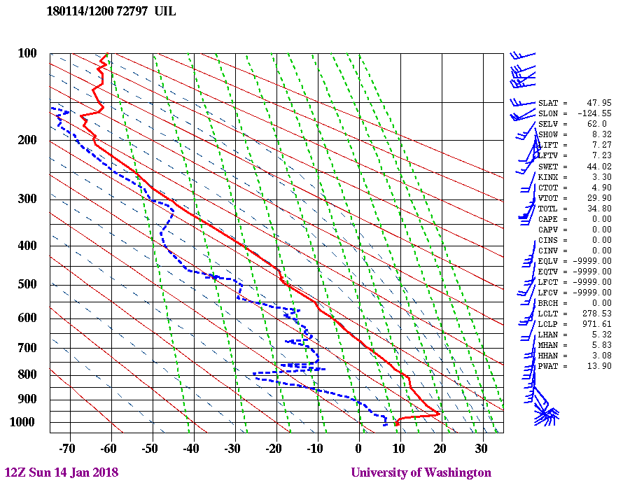
This morning's sounding at Quillayute, on the WA coast, shows a freezing level over 10,000 ft and an intense inversion (temperature increasing with height) in the lower few thousand feet (see below)

Yesterday's high temperatures got into the mid-50s all over the region yesterday, with some locations even rising into the mid-60s (only the highs above 54F are shown below).


The temperature this morning at 925 hPa (about 2700 ft)--16.4 C--was a record for the date and we have a strong offshore pressure difference this morning (much higher in eastern WA) that will produce offshore (easterly) flow and substantial downslope warming over the western slopes of the Cascades.  Mid-fifties will be commonplace and some locations downstream of terrain will get into the 60s.

Let me show you the latest UW WRF forecasts for surface (2-meter) air temperature--the details are fascinating.  Red indicates the warmest temperatures (check the legend below each figure).

At 8 AM, the State is divided in two:  cold east of the Cascade crest and warmer to the west.  But notice there are ribbons of greater warmth along the western slopes of the Cascades and to the west of the Olympics--this is due to the downslope warming (air warms by compression as it sinks down the slopes).   So at 8 AM, head to North Bend, WA or the Olympic Coast for warmth,


By 10 AM, the warmth along the Cascade slopes and along the coast will be profound, with lots of locations well into 50s and even near 60F.


But the situation at 2 PM will amaze, upper 50s to lower 60s everywhere, with some locations getting above 65F.  It will feel like spring.


The only thing holding things back is the strong inversion (which represent great stability and slow the mixing of warm air down) and the fog that covers some areas this morning (see 9 AM satellite picture).   Fog covers the southern Sound, parts of the Strait, and extreme NW Washington. And, of course the eastern slopes of the Cascades and the passes.


So enjoy the warm days...things will change greatly this week.

Important Milestone: The Current El Nino Has Hit Its Peak Early

The very strong El Nino appears to have hit its peak earlier than predicted a few months ago, suggesting a substantial weakening later this ...