The next 24 hours are going to be meteorologically exciting as a powerful storm grows rapidly offshore.
And before I say more, let me make clear that the inland areas of the Northwest will NOT get a major blow from this. Along the coast and particularly along the coast of Vancouver Island, this will be a significant event.
But this storm is remarkable for several reasons and thus is worthy of description. And is predicted to be a bomb cyclone, in which the central pressure lowers by more than 24 hPa in 24 h.
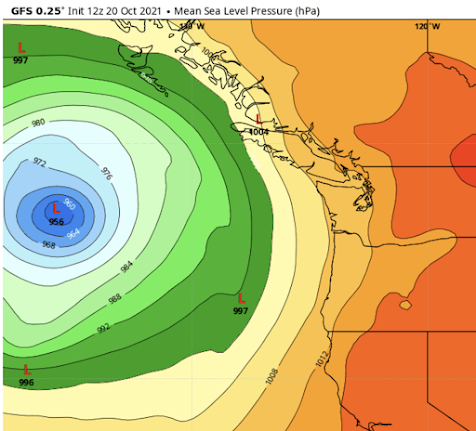
The latest NOAA/GFS forecast for sea level pressure at 5 AM tomorrow morning, shows a deep low off our coast, with a central pressure of 956 hPa. A very, very deep storm for our latitudes, and lower than some category 1 and 2 hurricanes. If this storm had been shifted a few hundred miles eastward, the damage would have been terrible. But it will not do this: model solutions have converged, with little chance of an inland path.
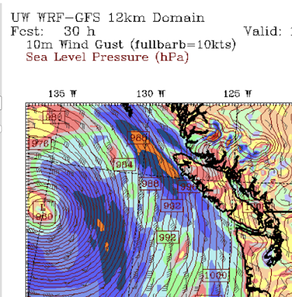
The wind forecast for 5 PM tomorrow shows gusts reaching 50-60 knots off our coast, and even stronger near the low center.
And the Seattle Windwatch wind gust forecast for 11 AM tomorrow predicts 60-80 mph just off the coast, and 30-50 mph gusts along the Washington coast and over the western Strait of Juan de Fuca. Not a good day to head out to sea.
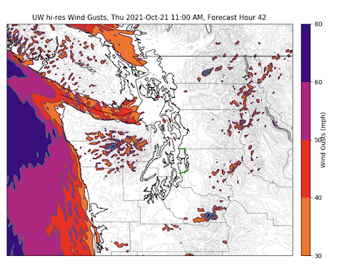
The most extreme coastal winds will be along the northern coast of Vancouver Island, where 60-70 mph gusts (orange colors) are predicted around 11 AM. This is the result of a strong pressure difference coupled with the high terrain near the coast.
If this storm pans out, it will be a remarkable success for numerical weather prediction, considering the difficulty of predicting the rapid intensification of a tropical system moving northward into the midlatitudes.
Imagine.
Predicting the path of a storm over thousands of miles, as it switches its energy sources (from warm water and tropical moisture to horizontal temperature differences) and structure (symmetric tropic storm with fronts to a highly asymmetric storm with fronts), while predicting radical changes it is strength....and doing it all correctly.... is an extraordinary feat.
A feat of prediction we could not have done two decades ago.
And to be a little controversial for a second, some of this extraordinary technology might be of value to other communities, such as those that do epidemiological prediction.
_____________________________________________


Gosh I sure hope you are right about the worst not coming here. Forgive me for not forgetting all the times the forecast has been wrong. Sort of scary just thinking about it. Counting on you and the science. Thanks for being there. (Praying for our Canadian neighbors north of us)
ReplyDeleteHi Cliff, Could you do a post on the 'Grand Solar Minimum' that we keep hearing about, and what it means for us in the NW, and maybe timelines? Thank you.
ReplyDeleteGrand solar minimum, speculation. Interesting if it happened that's for sure. More glaciers! Here's a fun model, just fun, no real science behind it. In this model, we should go back up soon. https://www.desmos.com/calculator/zpmjkpfjl4
DeleteHaving spent a lot of time in Ucluelet and Tofino (as well as Sooke), I hope this doesn't pan out as forecasted. Lot of nice folks up there, and it would be devastating for such a beautiful area.
ReplyDelete"But this storm is remarkable for several reasons and thus is worthy of description. And is predicted to be a bomb cyclone, in which the central pressure lowers by more than hPa in 24 h."
ReplyDeleteIs there a number missing here?
There is a 24 in front of hPa in the story.
DeleteThanks for the great and very interesting explanation and tidbits of info.
ReplyDeleteThanks for another excellent write-up. Hope all is well!
ReplyDeleteHow often do these kind of events happen?
ReplyDeleteStorm management is indeed a really difficult task to undertake
ReplyDeleteCliff, can you expand on the "little controversial" ending? What do you mean?
ReplyDeleteAGW, of course! Just wait until it's over, all the news will be screeching about the real underlying cause of this storm.
ReplyDeleteThe model was remarkably accurate, even underestimated windspeeds a little (Solander Island, NW Vancouver Island had wind gusts of 100 mph this morning). On the WindyTV model its showing Sunday's developing low to be even deeper - into the 940's - is that likely and is it even more remarkable?
ReplyDelete