Forecasting snow in western Washington is very difficult, even with modern prediction tools.
Before high-resolution models and satellite observations over the Pacific, it was nearly impossible to accurately predict local snow events and major local snowstorms occurred with little warning (for example, December 18, 1990).
Consider:
1. There is roughly a one to ten ratio between precipitation totals (amount of water falling from the sky) and snow totals, so a small error in precipitation amounts results in huge snowfall errors. Making a 0.10 error in precipitation provides a 1-inch error in snowfall.
2. Temperatures over the western lowlands are often marginal for snow. Right on the edge. So small temperature errors can produce huge changes in snowfall. Same with small changes in elevation or distance from the warm water.
3. There are huge local differences in precipitation because of our local terrain, such as rainshadows, convergence zones, gaps winds, and more. Plus, our complex land-water contrasts.
It ain't Kansas around here. And forecasting snow in Kansas is a piece of cake compared to our challenges.
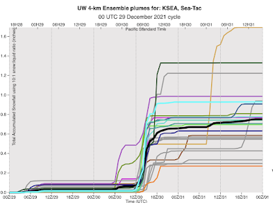
The snow forecast tomorrow has all of these elements, with the snow mainly between midnight and 10 AM,
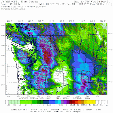
Here is the snowfall total for the period through 2PM Thursday. Healthy totals in the mountains. Little on the coast and the Strait where temperatures will be too warm. Less in the lee of the Olympics mainly because of snow shadowing in the lee of the Olympics. And temperatures will be on the edge for the southern Sound (yes--Puget Sound will see temperatures rise above freezing tomorrow late morning and afternoon)


"..keep in mind that snow depth increases are LESS than snowfall increases."
ReplyDeletei can keep that in mind... gormless as to what it means, but it's well in mind [wink]
As Cliff mentioned, he talked about it a post or two ago. Here's my understanding.
DeleteWhen temperatures are right around 32F/freezing, snow will melt somewhat when it gets on the ground. Yes, even when it's covering an existing base of snow, like we have now. So while we might get (x) many inches fall, only (y) inches will accumulate, because of that melting. The colder it gets, the less the difference.
Does that make sense?
Yes- although when the ground is cold- and it is probably below freezing now- your X and Y will, I think, be nearly identical. If course, there is also a packing effect- when the snow gets deep, the lower layers get compressed (and the water equivalent in them increases). But this will not be important for a shallow snowpack, it least initially.
DeleteThank you. Now I get it and like it. Really hoping not too much more accumulates.
DeleteYou also have to take in to account that while the air temp may start out marginal, as that snow falls through the dry winter air (depending where you are in the state) that snow melts on its way down and evaporates, cooling the air. As this happens you will slowly start to see the snow depth increase more if it last long enough as less snow will melt on its way to the ground.
DeleteWith this last bit of snow, (4am Thursday) I have already seen this happen in Edmonds. It got to be around -1C to 0C before the precip started falling, then dropped sharply during the heavy snow and started to really cover ground again once the temp dropped back to well below freezing.
Not sure if causation verse correlation but that's my observation.
Where I live (Totten Inlet) summer wind forecasts are off too. A typical forecast of 6 - 8 knots will often be 25 knots or none at all.
ReplyDeleteHey Cliff, just wanted to say thanks for all these in-depth weather updates. It's miles beyond whatever we get on the TV or the usual weather report, and extremely fascinating. The context of all the physical mechanics and the uncertainties in the forecast models really add up to a story that's more than "it's going to snow tomorrow". I think the world would be a safer, more prepared place if there were more people like you who could better translate what's going on for the rest of us.
ReplyDeleteIsn't it fair to question climate models given the uncertainty inherent in weather models?
ReplyDeleteIt is arrogance to believe that we can control climate variables. Over thousands of years, the climate has warmed, the climate has cooled. It is a natural occurrence that would take place humans or no humans. Does that mean we go dump a bunch of tires on a fire? No! That would be irresponsible. Do what you can to make common sense decisions that are good for you, your family and earth and quit trying to force electric car mandates by x date. And, stop to think. What powers those electric batteries when they are recharged? Use the power of critical thinking and don’t make any of this political.
DeleteIt's difficult to predict the next coin flip, but easy to estimate number of heads over the course of the next 200 coin flips.
DeleteCheckmate, atheists
DeleteIt's not widely understood that there is a key difference between weather and climate. Of course there are uncertainties, but an increase in greenhouse (i.e., heat trapping) gasses, mainly but not entirely carbon dioxide, will cause an average increase in Earth's temperature. It is much more difficult to predict the effect on a specific region, and impossible to predict the effect at a specific time or on a specific storm. Regional precipitation changes will also be hard to predict, but educated guesses can be made.
DeleteIn short, weather is about specifics, and climate is about averages.
Wrong. Your understanding of CO2 properties is extremely myopic, and this is exactly why you should not just blindly agree with the narrative that has been presented to us, ever since they decided to ditch the global cooling fear nonsense in the 70s. Please do better research before attempting to sound like you know what you are talking about.
DeleteBy measuring the wavelengths of infrared radiation that reaches the surface, scientists know that carbon dioxide, ozone, and methane are significantly contributing to rising global temperatures. Credit: Evans 2006 via Skeptical Science.
DeleteThis is a proven fact. Please do better research before attempting to sound like you know what you are talking about.
Fact: CO2 absorbs more longwave IR radiation than oxygen and nitrogen do.
DeleteFact: Visible light is in part converted to IR radiation when sunlight warms the ground.
Fact: Humans have increased CO2 concentration in the air since the year 1800.
Make your own conclusion...
Vancouver WA looks to get a good amount of snow before it turns to rain
ReplyDeleteWhatever th forecast may be in true PNW style grocery stores everywhere are completely stripped! I'll never understand why people need to panic in this way.
ReplyDeleteHave you seen reactions to Covid last 2+ and still going. People love panic and sensationalism. Our local news media is glad to oblige and contribute greatly to fear and panic.
DeleteHave you seen reactions to Covid last 2+ and still going. People love panic and sensationalism. Our local news media is glad to oblige and contribute greatly to fear and panic.
DeleteFear is comfortable for most people who would rather be told what to do than think for themselves. This abdication of personal responsibility needs to stop, immediately.
DeleteFor me it wasn't panic, it was restocking after Christman and pre-year (more like a regular weekly shopping trip). My only "concern", not worry, is if the snow is the heavy wet stuff that might down trees and knock out power. So yes, my concern had me buy some extra pop tarts.
DeleteAgree. This is why Covid reactions overreach realities. This is why store shelves are barren every time it snows 2-3 inches and lasts a few days. It’s scary how people cannot think or deal with things themselves. That’s why we are so quick to give up liberties snd “trust” authorities.
DeleteI am predicting 4 inches of snow in most locales. Based on the data shown in the e-models, it is indisputable that that will be the outcome of this "event".
ReplyDeleteThe rain to snow ratio is 1 :10 not 10:1
ReplyDeleteHow much does the elevation factor into a 1-inch error in snowfall. Eastern Mount Vernon foothills, it seems like there is more snow, just 100 feet higher, than the state highway 538 at hwy 9.
ReplyDeleteSnowing now in Matthew’s Beach! Bring it on :)
ReplyDeleteThat 18z GFS forecast for next week...sure is something. It would bring Seattle to its proverbial knees. So very different from ECMWF. Which will be correct? Stay tuned to find out.
ReplyDeleteModerate snowfall started at 9pm pacific in east auburn (Lea Hill) about 500ft. 26f with 0mph wind.
ReplyDeleteIsn't this way earlier than expected?
Kept seeing the snow wouldn't start in Federal Way till after midnight and the model shows under an inch through tomorrow... Started snowing two hours ago and already over an inch of new snow.
ReplyDeleteHey Clive, near the foothills even at low elevation. Like in granite falls sultan seem to get more precipitation. I believe then mountains trap moisture. Just an observation from a life long Snohomish county resident. Cliff great job. Very hard to predict weather in pnw. Im not sure why weather is political? Get a life?
ReplyDeleteThanks. I hope Cliff can sometime discuss lowlands, foothills, mountains and weather differences.
DeleteWe woke up to an additional 4-5 inches in S Bellingham. Total level snow depth is approximately 13. This is the deepest snow we have had here in at least 20 years and just beats the 12 inches on the ground in December 2008.
ReplyDelete4" new snow and 25 degrees this morning on Hood Canal. Stopped snowing and it frankly quite a nice morning for a walk.
ReplyDelete"this ain't Kansas" and people like you get griped at because of it But Puget Sound is soo much more interesting to a meteorologist like yourself. Keep up the good work on the modeling.
ReplyDeleteAbout 6 cm of fresh snow on the ground this morning in North Ballard. Without the Olympics snow shadow would it have been 6 feet?
ReplyDelete5 feet -- exactly 60" as I write this -- since Dec. 13th in our part of the Columbia Gorge. And still snowing, so it'll be more for the month.
ReplyDelete