You have all heard of a rainshadow.
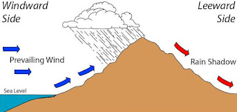
Air approaching a barrier rises on the windward side, producing lots of precipitation, while air sinks on the lee side, causing drying and a lack of rain (see graphic).
On Thursday, we are going to have a profound snow-shadow situation for large portions of the western Washington lowlands, particularly around Puget Sound, and snow lovers like myself are going to be disappointed.
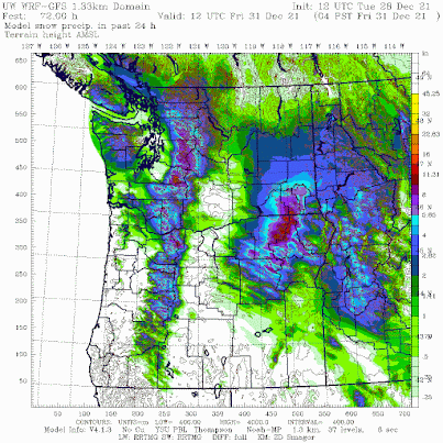
Below is the latest super-high resolution UW snowfall forecasts for the 24-h ending 4 AM Friday morning. Light green is less than an inch, while purples and darker colors indicate more than 6 inches.
Plenty of snow on the windward (western) sides of the Olympics and Cascades. Bellingham is going to be snowed in! But little around Puget Sound and virtually nothing from north Seattle to north Kitsap. No snow near Yakima on the eastern side of the Cascades.

So why so little snow around Puget Sound? The problem will not be the temperature--it will be cold enough to snow. The problem will be a lack of precipitation.
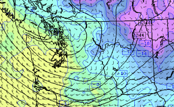
And that deficiency is due to the orientation of the winds in the lower atmosphere, which will be from the northwest, resulting in downward flow on the lee side of the Olympics.


My poor kid is going to be disappointed after the original forecast of 2 to 4 inches in Lynnwood. Looks like we are warming up for a bit, but is there any more snow on the long term forecasts for our normal snow time frame (end of Jan into Feb)?
ReplyDeleteI think you meant to write Blue Mountains and Southeast Washington.
ReplyDeleteIs there any sense when the bulk of the snow will fall? I want to try to take a video of myself dancing in a true blizzard.
ReplyDeleteWe will see. Recently the models have been underdoing snowfall, at least in Maple Valley where I live. Models predicted 1-5" snowfall with the initial storm and we finished with almost 8" actual snow depth. Last night we picked up another unforecasted 1.5".
ReplyDeleteWff255. You are dead on. I live in maple valley as well and as you said we got way more that projected on the first storm. And the same with last night's and early morning snowfall as well
DeleteYeah we got an unpredicted inch in Ballard/Sunset Hill last night too. Well, the iPhone weather app predicted it literally once it started, but that doesn’t really count 😅
DeleteI agree. In Ballard we ended up having 5.5 inch of snow by Monday morning. Forecast were only a couple of inch. Overnight we got 1/4 inch by this morning.
ReplyDeleteAgreed. In Sammamish we were predicted to get 3 inches from the original storm and we got 6. Furthermore, it said snow from 6am Sunday-1pm and it snowed until 6pm. I think these meteorologists under deliver because its so hard to pinpoint. The last 4 snow storms I have been a part of they have predicted a certain amount and 4-5 inches MORE have fallen every single time. Curious to see what tomorrow brings.
ReplyDeleteHere we have a perfect example of why climate modeling is so filled with faulty data, reasoning and assumptions:
ReplyDeletehttps://www.youtube.com/watch?v=5fQBo44Yw_s
This SF area weather forecaster is highly respected, yet he mentions at the beginning how dire the snowpack forecasts were, on December 5th (!). And now? Unbelievable snowpack levels, and more snow on the way before the first snowpack measurements on January 1st. Of course there's no explanation on why everyone was so wrong about their snowpack predictions for the Bay area, nor will there ever be any accountability for their mistakes. When it comes the the true believers of the Cult of AGW, you never have to say you're sorry.
It's not a cult.
ReplyDelete