The water situation is rapidly turning highly favorable for the West Coast, with particularly good news for California.
And bountiful snow is in store for the Northwest as well. But no lowland snow is forecast for western Washington--so if you were looking for a white Christmas near sea level, that looks improbable now.
The total precipitation amount (depth of water from rain and melted snow) through 4 PM next Saturday is impressive, with over five inches in the Cascades and MORE THAN ten inches for the Sierra Nevada.
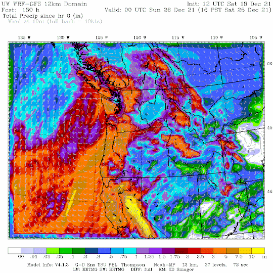
An extraordinarily valuable addition to the snowpack. By the time this event is over, the snowpack for the entire West Coast will be above normal.
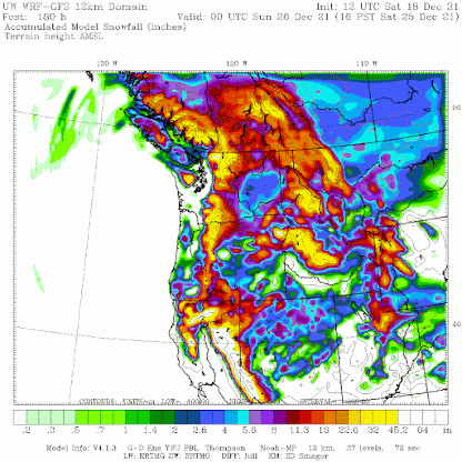
Good skiing is guaranteed for the Northwest for holiday season. And situation for water next summer appears to be quite favorable at this early vantage point.
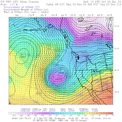
The origin of the precipitation bounty for California will be the development of a very deep trough of low pressure west of northern California (see the forecast for 4 PM on Wednesday). This feature will form on Sunday and amazingly will stay in place for much of the week. This feature will push moist, southwesterly flow into California, where it will be pushed upwards by the terrain, producing massive precipitation.


Battle Ground, WA had snow last night- enough to make the grass look white at 5am. It's slowly disappearing, and people are driving with no apparent issues.
ReplyDeleteCliff- I bought your book for my dad for Christmas. He is going to love it!
Thank you for the update. Is there any chance for lowland snow in the Whatcom area week after Christmas? Or is it too early to tell.
ReplyDeleteCliff, are you having second thoughts about your post of snow being improbable in the lowlands for Christmas?
ReplyDeleteBoth the GFS and EURO models seem to be favoring this possibility.
Euro says not so fast. It's actually pretty bullish for lowland snow for Christmas for north counties and above 500ft or so. Have to see if that idea persists through the next couple runs as it's still a few days out.
ReplyDeleteInserting useless global warming question **here**
ReplyDeleteSure looks like a white Christmas for lynden, snow forecasted dec.24th through the new year everyday. Here comes the northeastern...uh oh.
ReplyDeleteOkay but still no lowland snow? Because notional weather services say differently and I’m ready to wax up the sled.
ReplyDelete