I will have a Snow Update at Noon (Dec. 25th)
_____________________________________
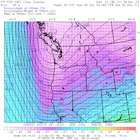
As we get closer to an event, very powerful tools become available to meteorologists: high-resolution model predictions, high-resolution ensembles of many forecasts, the NOAA/NWS HRRR model, to name only a few.
And forecast skill obviously improves as we get closer to the event.
So based on all this technology, and decades of experience in predicting Northwest snow, let me provide you with the latest update.
The temperatures are too warm for snow over the lowlands today, with the current freezing level approximately 2300 ft. The snow level (the level at which all snow is melted) is about 1000 ft lower (1300 ft).
Near-surface temperatures will remain above freezing throughout the night and Saturday morning/early afternoon. Temperatures will be a bit colder around Bellingham as cold Fraser River air starts to move in.
But around 4 PM tomorrow (Dec. 25th), all hell will break loose as Arctic air pushes energetically through the Fraser River Valley into NW Washington. Temperatures will rapidly fall below freezing in western Washington, with gusty winds from the north. Arctic air will also push south into eastern Washington.
Trust me...you will know this is happening....the equivalent to being hit by a meteorological sledgehammer.
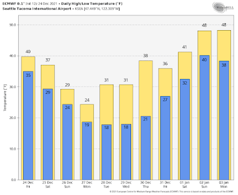
Here are the daily high/low predictions from the European Center model for Seattle. By Monday, a high of 24 and a low of 19F, with the lows cooling a bit the next few days, followed by warming at the end of the month.
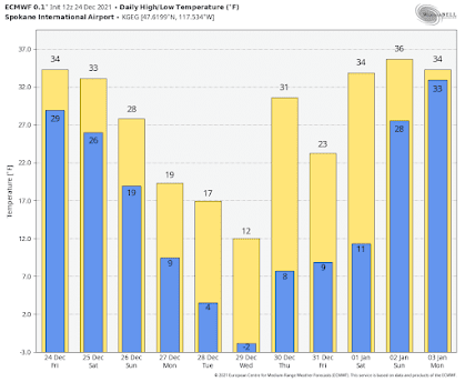
Spokane (and eastern WA) will be much cooler, with highs in the teens, and lows falling below zero.
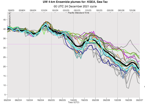
The UW high-resolution ensemble system, with the WRF model run many times with small differences in its starting point and physics, is a powerful tool for looking at uncertainty. Below are the forecast temperatures at SeaTac, time is on the x-axis and 00Z/26 is tomorrow at 4PM.
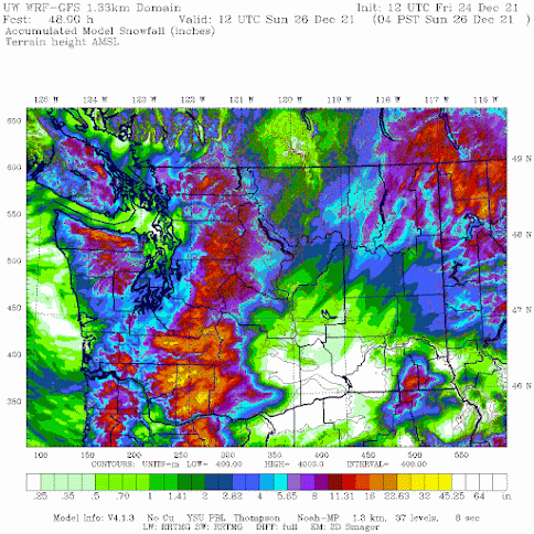
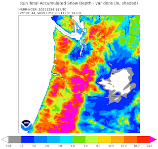
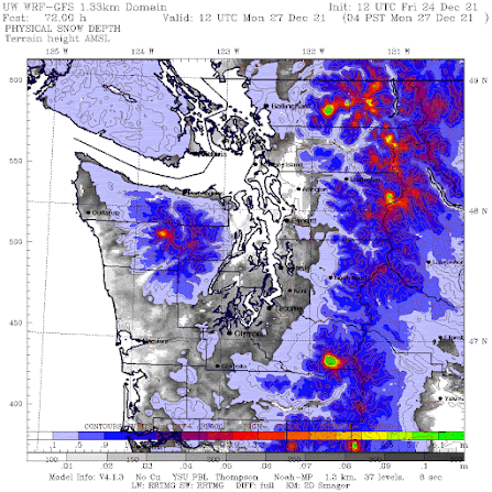
But the predicted snow DEPTH on Monday morning at 4 AM, after another 24 h of scattered showers, is unimpressive. Yes, the ground will be white around Puget Sound, but generally less than .06 meters (about 2.5 inches). Not big snowfall that kids (both young and old look for).


Would like to know why the models are so different this close to the event... GFS showing 8F and ECMWF showing 20F for Monday morning
ReplyDeleteIt's incredible how all the models could be so confident about the below freezing weather for such a long period, and then just suddenly remove it. I'm seeing mid 40's for the end of next week as of today's forecast. Just yesterday and several days before the forecasts from all models were showing below freeing, single digits, and teens for the entirety of next week and beyond.
ReplyDeleteWell. Thanks gods for that!
DeleteThanks for the update! Are we seeing any potential snow in the long term forecasts through mid January? I know you said the EU model previously was showing a good amount through Jan 14...is that still the case?
ReplyDeleteHi I'm one of those amateur weather enthusiasts I only follow you and your blog posts and I read a ton on NOAA and browse the weather models.. I share your blog posts on my Facebook page "THE BEARCAST" I encourage you to check it out! Let me know what ya think. I'm open to constructive criticism. Once again.. YOU ROCK!
ReplyDeleteNot doubting your guidance, but curious what the source of the WWA would be given your outlook?
ReplyDeleteThanks for the current info. For the past week, I've been keeping track of how cold it's going to get, and for how many days and nights. I'm glad to see that the most severe of the cold weather won't last as long as first anticipated, mostly because I worry about those who are outside. I used to work with some people without shelter when I lived in Southern California, but have never understood how they survive in cold weather, especially in the time of Covid when shelters are more sparse.
ReplyDeleteMy heart aches at this time of year for those on the streets. I was able to help many people get off drugs and alcohol. I didn't get paid. It was just something I wanted to do. I'm fairly disabled now, but if I was able-bodied, I like to think I'd do my part to help.
Happy Holidays to anyone reading this.
Thank you for all you have done. Merry Christmas to you!
DeleteI knew it wouldn't hit zero in Seattle. It won't even hit below the teens. Now, the winter of 1968-1969 was a doozy. You found out very quickly who put anti-freeze in their radiators, and who did not. Uff da. Almost reminded me of my one Thanksgiving in North Dakota.
ReplyDeleteWould love to know more about bellingham and whatcom county, where it's currently snowing lightly and 32 degrees at 6:40 Christmas Eve.
ReplyDeleteHappy Christmas!
2.5 inches of snow may not be an amazing amount, but it is enough to make holiday lights very pretty. There is nothing quite like the look of holiday lights reflecting on snow. Something I miss from my Wisconsin upbringing (though there's not a lot of snowcover in Wisconsin this Christmas).
ReplyDeleteCentral Kitsap Uplands checking in. White Christmas confirmed as of 9pm Christmas Eve and still snowing. The roads are probably winter driving conditions. Be safe out there!
ReplyDeleteI know some have mentioned the interesting "softening" of the severe cold in the forecasts. If we look at "climate change", would it not explain why models in the summer may underestimate heat, and models in the winter may overestimate how cold it can get in 2021? I saw our June record heat out preform expectations....can't recall a winter forecast getting colder than the early models.
ReplyDelete10:00 pm on Christmas eve and we have 2" of snow on the ground here in Central Kitsap! Lovely!!!
ReplyDeleteWell I woke up to another green Christmas, and I have to say Cliff "Most will wake up to experience a snowless Christmas morning" was a gutsy and excellent forecast. That was certainly correct here in Mountlake Terrace. Happy Holidays!
ReplyDeleteI woke up to a white Christmas in north Lynnwood. Quite lovely!
ReplyDeletesnow on the ground here in Sequim but not sticking to paved roads. Snow stopped about 45 minutes ago.
ReplyDeleteHere in Bellingham, I went to bed with the snow just starting, now at 11:45AM there's a good 4 inches at my house. Absolutely beautiful.
ReplyDeleteWoke up to a white Christmas here in Bellingham, so quiet and beautiful.
ReplyDeleteSnowing since 8am, winds with gusts to 25mpg. Temp 20 degrees without the windchill. We have 3-4” of snow so far with no end in site. Bellingham/Ferndale line
ReplyDeleteSame here in Bellingham (Cornwall Park Area); about 5 inches and 20 or so. As of about 10 PM on the 25th.
ReplyDeleteThank you so much for all your hard work Mr. Mass. And it's amazing how many smart people who know so much about meteorology comment here! I love reading everything here when there are weather events like this. "I know I have to go to sleep, but let me check Cliff's blog just one more time..."
ReplyDeleteLove to all!