Some light snow has fallen around Bellingham and environs in the Fraser River outflow (see below), and modest snow has also fallen to the southeast of the Olympics over portions of the Kitsap Peninsula. Snow has whitened the region above roughly 1000ft, and heavy snow continues to fall in the mountains.
I5 north of Bellingham
But the real action is ahead, both in cold and snow, and it appears that we have a shot of more extensive lowland snow on Thursday.
The Cold
A modified Arctic front will move through Puget Sound around midnight. Temperatures will plummet with its passage, which will also be accompanied by a dramatic shift in wind direction to the north. Cold air has already started to pour through the Fraser River gap into Northwest Washington, with temperatures dropping into the mid to low 30s, borne by strong northeasterly winds (see map for 11 AM, red numbers are gusts in mph).
The forecasts are now consistent and reliable.... western Washington will experience temperatures dropping to the lower to mid-teens, while eastern Washington will get the full arctic treatment, with highs in the single digits and lows below zero (see European Center temperature forecasts below)
A number of eastern Washington locations will experience more than 100F swings between the highs last June and the lows this week. A few westside locations may as well--which will be unprecedented in the historical record.
Many locations around the Northwest will experience daily (not all-time) low-temperature records. And if you want to be impressed, consider the temperature at around 800 meters above the surface at Quillayute on the Washington NW coast (925hPa pressure level). It will be the second coldest time in the 73-year record there (see plot below, the red star is the forecast temperatures at that level, the blue line shows the record low temperatures for that date).
Snow
Like politics, snow is essentially local in nature. Today, snow is all about temperature, with the atmosphere being generally a bit too warm for snow near sea level.
There is light snow over NW Washington because of the cold air coming out of the Fraser River Valley.
This evening, as strong northeasterly flow pushes out of the Fraser River Valley, it will be forced upwards on the NE side of the Olympics, producing localized heavy snow. The rainshadow folks around Sequim and Port Townsend will experience precipitation like the rest of us.....you have to smirk about that.
3-h snowfall and low-level winds valid at 7 PM tonight
Why is the cold air pouring out of the Fraser River valley and points north?
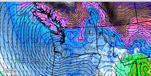
Because a low-pressure system will be moving eastward across southwest Washington (see surface map at 4 AM tomorrow morning). With intense cold, high pressure over BC, and lower pressure near the entrance to the Columbia River, cold air is being pushed to the south.
Sea level pressure (solid lines, and 800-meter temperatures, colors)--brown and purple are the coldest temperatures.
Overnight the leading edge of the cold air, the arctic front, will move though--not only supplying cold air but providing uplift that produces precipitation--snow. That will be aided by an upper-level trough moving through.
By tomorrow morning, most of western Washington will have some light snow.....generally no more than an inch or two. The 24h snowfall ending 4 PM Sunday is shown below. Greens are less than 2 inches, with blues (2-4 inches) generally east of Puget Sound.
But this is snowfall....which includes snow that will melt. The amount predicted to be on the ground at 10 AM tomorrow is not so impressive (see below). Colors start at 3.7 inches. Grays indicate lighter snow amounts (in meters).
Enough snow to whiten the region a bit. And snow is a cooling machine...reflecting solar radiation to space and emitting infrared radiation from the surface.Finally, the big lowland snow threat in the future. On Thursday, cold air will be in place and a Pacific front will approach, resulting in precipitation (snow). The 24-h snowfall ending 4 AM Friday is much more significant for central Puget Sound. More on this as we get closer.


This comment has been removed by the author.
ReplyDeleteSo we live in the heart of Bellingham, and we have 5" on the ground and it is still coming down. I'm confused by the maps that show an inch on the ground for Bellingham? We're more likely to have a foot of snow by tomorrow morning?
ReplyDeleteWhere we live in Bellingham, Fairhaven, we have seven inches of snow as of Sunday morning, and I can see more falling (not just blown from the branches of trees). We love a snowy winter day, so it was a real treat for us to see snow on Christmas morning. The last time we experienced snow at Christmas, it was in December 2008, when we were still living in Seattle, close to the downtown core. We had a table on our deck and watched the snow pile grow higher over the course of several days. It made getting around in vehicles difficult, but there was also a festive atmosphere because of the holidays, and a lot of people walked to where they needed to go. If I'm going to experience an extreme weather event, I'd rather it be snow and cold than the extreme heat we had this summer.
DeleteThank you, Cliff, for sharing your Christmas Day with us and providing our most trusted forecast.
ReplyDeleteProfessor thanks for taking your time to keep us updated through the Holidays. The weather never rests!
ReplyDeleteThanks for the update. And Merry Christmas!
ReplyDeleteI realized snow is variable but a tad more than light snow in bellingham. Here in Sudden Valley we have 6+ inches and its not stopping.
ReplyDeleteIt's been snowing pretty heavily all day today near the Canadian border... Temperature is 19 degrees here in Lynden and pretty windy. It was even snowing a little yesterday and never rained like it was supposed to.
ReplyDeleteLove it. Earlier article reads most will enjoy a white Christmas to now nothing and more then likely nothing at all. We get more snow when you weather folks don't predict it then when you do. Time and time again
ReplyDeleteI dont remember any entry saying more than some places could see snow for xmas...
Delete@Blogger I'm curious where you saw on this blog that "most will enjoy a white Christmas." Perhaps you should read your source again. Weather forecasting is nonetheless a very difficult job (especially when it comes to snow in the PNW) so thanks Cliff and everyone for your very informed and detailed info.
DeleteI fully agree with you Blogger. I live in the foothills east of Sumas, we have about 9" on the ground. We got 3" yesterday that wasn't forecast. Let it Snow!
ReplyDeleteA good ~9" in Bellingham by now and still snowing heavily at 25 degrees and dropping fast.
DeleteUhhhh still waiting Cliff. Too much staring at models I think.
ReplyDeleteMy folks live just west of Port Angeles in Joyce and they have received 12" today alone, and the upslope flow is just now starting at 9pm tonight, going to see some big totals out there for sure. Thanks for the weather blogs Cliff!
ReplyDeleteChecking in from Port Townsend, where it's currently snowing and sticking! I'll take that smirk, thanks:)
ReplyDeleteStill waiting for snow in Battle Ground, WA.
ReplyDeleteSigh.
Cliff- my dad is loving your book!
I see a really interesting localized very cold spot showing up in the forecast just north of Seattle. It shows up Monday morning on the 1.33 and 4 km GFS temperature maps, but is averaged out on the 12 km map.
ReplyDeleteTake a look at the 4 AM (12 UTC) 12/27 Puget Sound map and look for the white streak along US-2 and the Snohomish River Valley: -8 degrees F, within just a few miles of the warm Sound.
The temperature rapidly rises once out of the river valley, but it's an impressively localized inversion.
1AM 12/26…12” on the ground at 800ft in Port Angeles. Nearly a white our as I type this.
ReplyDelete7" of snow at 300ft in Anacortes at 1 am dec 26th. The sky is clearing and it's 21 degrees and gusty.
ReplyDeleteNorth Whatcom County had far more snow already by Saturday midday than suggested here. Now (early Sunday morning) we’re looking at close to a foot. Unfortunately it’s accompanied as usual by the godforsaken northeaster. Drifting and a real feel of minus 8. Not fun.
ReplyDelete6" of snow on Orcas at 6 am Dec 26th. 25 mph NE winds ... wind chill 0
ReplyDeleteDitto for Port Angeles at 800’. Lots of snow via lake effect, nearly 16” as of 6:30 am.
ReplyDeleteHey Brad... KK here
DeleteWe only got 4" here above hood canal
A tiggle and a goat enthusiast...this blog is MEGA!
DeleteNever know when MEGA will appear! Digging ourselves out…
DeleteA major ice storm is going on now in Anchorage and Fairbanks.Temps there will be warmer than the Puget Sound area by tomorrow.We know where their Arctic air has gone!
ReplyDelete4-5 inches on Bainbridge, Rolling Bay area Dec 26th. Still snowing and 26 degrees
ReplyDelete5" on our glass garden table in the back, at 168' altitude near Dahl Field, just north of UW in Seattle. Way more than I expected, based on what I read. Still snowing lightly.
ReplyDeleteModels definitely underperformed on snow amounts. The central sound is going to get dumped on today.
ReplyDeleteAgree, 6 inches on the ground in Puyallup at noon with it still snowing an inch/hour, we could easily end up with a foot on the ground if it keeps up.
DeleteSnowing hard in Gig Harbor. The radar shows the heavy snow band is west of puget sound not east as forecast.
ReplyDelete3" at 500' in Silverdale at 9 a.m., and still snowing.
ReplyDelete13+ inches in East Port Angeles- 600ft elevation- Still snowing
ReplyDeleteOn Sinclair Inlet, Kitsap Lake, and uplands near Silverdale, 3 inches on the ground and still snowing.
ReplyDelete23 just west of Port Angeles at 900 ft.This is the kind that lasts weeks.
ReplyDelete3-4 in Shoreline. No snow in the lowlands?? Mother Nature doesn’t read computer models.
ReplyDeleteDoes anyone know of a blog similar to Cliff's but for weather in the Midwest? My sister lives 50 miles west of Chicago, and I sometimes send her links to things Cliff posts so that she can see the weather we have here, but it occurred to me that she might enjoy something similar that covers her area.
ReplyDeleteSolid 6 inches and still steadily snowing in Hilltop/Central Tacoma. 27F degrees, windy, feels like 16F.
ReplyDeleteI like this post thanks for this information such a usefully information please provide a few more information about this post.Psychiatrist in Battle Creek
ReplyDelete