Weather prediction technology has come a huge way over the past decades and yesterday's localized snow event is a great example of how far we have come.
The most difficult Northwest forecasting problem is snow prediction.
And there is no harder snow problem than a situation marginal for snow and where there are very localized weather effects.
Yesterday (Tuesday) was such a difficult snow situation and the high-resolution models did very well.
The Forecast
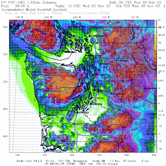
As I described in this blog, cold air was in place and an approaching frontal system brought general very light snow, with heavier snow over North Seattle and Snohomish counties. The models also predicted heavy snow in the Cascades, including its lower western slopes.
Below is the high-resolution WRF model forecast of snowfall through 4 AM today (Wednesday) made 4 PM Monday.
Light snow from downtown through Tacoma (about 3/4 inch), with heavier snowfall (peaking at 5-7 inches) from Lynwood to Everett. Heavy snow in the mountains.
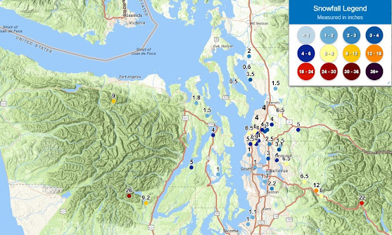
Huge spatial variations. The NWS put out of map with snow reports (see below--with a few additions I put on). The forecast was very, very good.
We simply could not have done anything like this 20 years ago. And this success is not a one-off. Remember the big heat wave in June 2021? We correctly forecast record-breaking temperatures days before. I could give you a dozen other examples of great success.
Improved weather prediction allows society to deal with extreme and unusual weather in a way impossible only a few years ago.
The Problem
Society needs to recognize and use these improved forecasts. Case in point: Seattle Tacoma Airport yesterday. To put it mildly, it was bedlam. Less than an inch of snow resulted in dozens of cancellations and flights delayed for 1-3 hours. The situation was particularly bad for Alaska Airlines, which lacked sufficient deicing capabilities.
The potential for light snow was in the forecast and temperatures were not that cold (just near freezing) that morning. The snow reached the airport around 7:45 AM. Someone from Alaska Airlines told me the issue was that a lot of planes were sitting around on the tarmac overnight and they did not have the hanger capacity to keep them under cover.
How about this suggestion? Put large tarps over all the wings and critical surfaces for planes on the ground during such rare situations? Tarps are cheap.
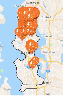
And then there were the massive power outages from wet snow on branches. Local utilities need to put far more emphasis on vegetation management around their powerlines. Seattle City Light's major outages were in the northern (snowy) side of the city (see below)
The Next Event
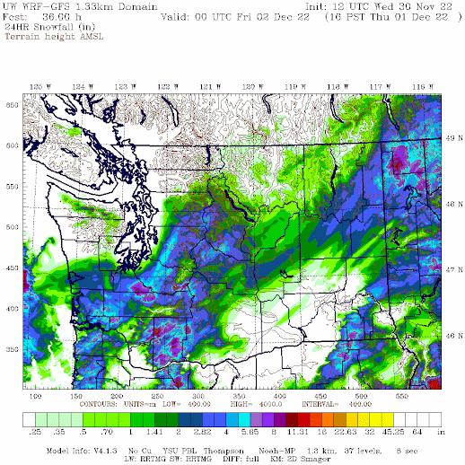
More snow and cold are coming to our region, and the snow distribution should be very different. Most of the lowland snow action will be to the south.
Here are the 24 h snowfall totals ending 4 PM Thursday. Snow from Olympia or Tacoma south. Snow over SW Washington and the southern Cascades as well as a good swath of eastern WA.
There is some uncertainty to the northern edge of the snowband...keep that in mind
But WAIT! The snow possibilities don't end there! ANOTHER low center will move offshore Friday afternoon with another front approaching Friday night (see sea level pressure forecast, with low-level temperatures, for 4 PM Friday.
This might bring a burst of light snow to Puget Sound country overnight (Friday/Saturday), with more snow to the mountain (see 24h snowfall ending 4AM Saturday)
Someone should drop off some big tarps at SeaTac Airport for our friends at Alaska Airlines.


.gif)


Snowing in East Redmond now.
ReplyDeleteLiving in south king sure is boring when it comes to snow and wind weather. Too far south to get the north snow. Too far north to get the south snow.
ReplyDeleteAlso wanted to point out there's huge gaps of unreported snowfall along the hwy 18 corridor from East Auburn all the way up to around Hobart. They had at least a few inches fall all night, still have tons of snow on the ground right now, but there's nothing being reported about their snow (or their wind). I'm referring to areas like covington, maple valley, hobart, may valley, etc.
Except in my one specific corner near Federal Way, hills or something must be just right because my street always sees way more than even just a half mile away.
DeleteYour predictions of the June 2021 heat wave were amazing.
Delete1pm pouring down in Crossroads and 32 get on 405 and it's 36 in Kirkland and rain sire wish they wouldn't cancel after school stuff so quickly
ReplyDeleteI remember flying into SeaTac one time, looking out the window, I heard a lady say "everyone seems to have a swimming pool here!". She was looking at all the blue tarps everyone uses to cover everything here.
ReplyDeleteTarps? It may be more complicated due to regulations. Deicing and tarps involves labor and we all know corporations will do everything possible to avoid that.
ReplyDeleteLike. The old school way.
DeleteWith snow forecast I bring wood in and take seeds for birds out. Currently there are about 5 inches. That's enough. Please stop. [5 miles NE of the airport - KELN - at Ellensburg.]
ReplyDeleteso...tarps have metal grommets. metal grommets can (and often do) fall off. if a metal grommet gets sucked into a jet engine air intake, it will destroy the engine. bad enough if this happens before the plane is airborne... but imagine the carnage if a lost grommet gets lodged on some part of a wing/fuselage and is sucked in during takeoff/landing/inflight. i don't know what happens in commercial aviation but in the US Navy such FOD (flying object debris) is taken very seriously from a risk management POV. so much so, for example, that female pilots/aircrew are prohibited from wearing hairpins on the flightline, mechanics' logs strictly track nuts/bolts, etc. and if you don't have the same number of nuts/screws after you reassemble a working component (e.g. a radar) of a plane as you did before you took it apart, the plane is grounded until you find the missing bit, and squadrons perform a daily flightline activity known as the FOD walkdown to scan for anything which could potentially damage an engine. while i value your perspective and expertise, Cliff, on the challenges of weather forecasting in the complex microclimates which comprise the Puget Sound region (your predictions and scenarios for the northwest Hood Canal area were very good for this week's snow events), your comment re: tarping commerical airplanes (and the sycophantic echos in the comments, like those re: woodstoves a few weeks back) are a great reminder for me of the folly of ignorance and groupthink, which sadly seems to be more prevalent the more "education" one has. hopefully, those who work the commercial flightlines and are actually responsible for managing risk don't get their ice prevention or logistical tips from a weather blog.
ReplyDeleteI bet one can buy tarps without grommets....🧐
DeleteTarps would be problematic for sure but, not impossible. Damage to the aircraft during installation and removal would be a very real possibility not to mention the labor hours involved in this process. Operating from a major airport that is prepared for extreme weather is a much better plan.
DeleteIt's not done because it's a terrible idea in practice. It can work for small aircraft but not transport category commercial aircraft. And.....it's not allowed by regulation. The simple fact is when aircraft have to deice it is a slow process. You can't move as many aircraft at the same rate no matter how much deicing equipment is available. The only reason Alaska is more effected is because it's their biggest hub and they operate the most aircraft there by far. Consequently they are the most effected. The idea that it's just the company being cheap is silly. Delays and cancellations cost far more than having deice equipment around. And lastly, how about we remember how remarkable it is just to be ABLE to get in an airplane in the middle of a snow storm and go flying. The engineering and practices that make that even possible are amazing to me.
DeleteHaving lived in Chicago and undergone literally thousands of business trips from O'Hare to easterm seaboard cities in the dead of winter, the problems of deicing you're describing rarely occur, unless a sudden snow squall happens right before takeoff. Airlines who fly out of cold - related cities are well prepared for most kinds of winter weather, even ice storms. So in effect, it is the airline being cheap, period. Full stop.
DeleteThe high rez models nailed the forecast for us at 500' above Hood Canal. 8 inches on the ground this morning, additional light snow falling currently. Looks like Friday will be another good shot out here, with perhaps a bit Thursday too.
ReplyDeleteNo power, no internet...31⁰
Weather forecasters got a lot of grief in the 80s when their predictions of snow failed to materialize. Too many people were staying home, expecting a snow day, and nothing happened. I have to think the criticism played a part in the missed forecast of 1989. What a mess that was.
ReplyDeleteAre you actually meaning the big snow of '85? That was a mess. I don't recall a big snow in '89 at all. The snow that hit in '85 had the parts to make it happen, and it stalled out and dumped a boat load of snow, at least from Tacoma south.
DeleteTarps are cheap, but the labor needed to put them over all the airplane wings probably just doesn't exist.
ReplyDeleteIt has been snowing here for a bit in Tacoma. Just got back from the store. I think it began mid afternoon and everything is getting dusted, even the streets are beginning to show some of the white stuff. Largish flakes at the moment, and it was coming down good while at the Fred Meyer on Stevens and 19th. Even got gas while there. Home how and it's still coming down. Temps here 32-33 at the moment.
ReplyDeleteThe weather channel says snow and 33, the weather app Windows 10 uses is saying rain/snow. It's just plain ol' snow here. According to both the Weather Channel and Time and Date, both say 41 was the high. I highly doubt it, but OK, whatever...
Great job!! Totally awesome! Thank you Professor Mass!
ReplyDeleteThank you for your fascinating blog. I live in Seabeck on the Kitsap Peninsula. We received over a 9 inches of snow from this storm even though the NWS forecasted 1-3 inches. The snow came with intense thunder and lightning. I have only heard lightning with snow once before. Why does this sometimes happen? Thanks
ReplyDeleteBasically you need a vertical profile similar to summer storms. This requires very cold air aloft such that the cold surface air (which is still near or below freezing) will still be relatively warmer than the air above it as it is lifted from convergence/frontal passage etc.
DeleteThis morning there was more damage to the trees around me than in the windstorm a few weeks ago that knocked out power to over half the county, but fortunately no power outage for us this time.
ReplyDeleteI know tarps seem like a simple option from the perspective of a lay-person, but it's not actually very simple.
As a general observation, airlines invest a lot planner and analyst time in the office trying to figure out how to save money in their routine operations on the ramp. Alaska, like most major airlines, operates from plenty of airports where snow and ice cost them a lot more money than it does at SeaTac. If tarps were an effective way to make dealing with snow and ice faster and easier, they would already be doing it.
To hint at a couple of the drawbacks: as you know, it was pretty windy last night. I believe SeaTac was getting 30+ knot gusts. Imagine trying to tarp the wing of even a relatively modest-sized aircraft like a 737: The cheapest option is a step ladder, and I think a 10' version would be just tall enough to reach the upper surface of the wing out at the tip (assuming Alaska's safety organization would even ok using a step ladder on the ramp. I don't work for an airline, but the megacorp I do work for has more or less banned step ladders as a safety liability). It's going to take at least 2, probably 3 people to keep a hold of a 20' x 60' tarp in these gusty winds while on top of those ladders, without letting it break any antennas, air data probes, or the thin fairings around the wing root, while another worker ties the tarp down. Working from a boom lift would be easier, but a couple lifts adds up to a significant fraction of the cost of another deicer truck, and airlines generally don't like to have lifts moving around aircraft any more than necessary, because not infrequently, the planes get bumped and something has to get fixed.
Repeat 100+ times for all the aircraft that typically remain overnight at SeaTac.
When you get in this morning, there is literally over 1 ton of snow on the tarp (685 square feet per wing x 6" at 1/10th the density of liquid water) to be swept off before you can remove it, and if its still snowing, you may still have to go to deicing pad to remove what builds up during boarding.
I expect we are just going to see SeaTac continue to experience chaos a few days each year when snow exacerbates the existing crowding issues, because it's just not frequent enough to get airlines to invest in more deicing capacity.
With that said, weather forecasts should be a useful tool for airline planning for matters like managing overtime so you have enough workers who haven't hit their overtime limits when a storm hits to keep up with the increased work load that bad weather brings.
Well stated, those were my thoughts as well regarding tarping the wings. I'm not in the aviation sector, but in the profession I work in (emergency response),it's very common to hear solutions to seemingly simple problems from very smart people. But issues that are seemingly simple are often quite complex, and that complexity can be hard to see for those that don't have broad knowledge and experience in the given field.
DeleteThe forecast for E Kitsap was way off. W Kitsap/Hood Canal got the called for 6" or so, but Suquamish, Bainbridge, E Bremerton at most 1/2"
ReplyDeleteAgreed Cliff. Nicely written. Not sure why the NWS ended their snow headlines including Hood Canal storm warning. Made no sense.
ReplyDeleteThis was the coldest November at BLI since 1985 and the 4th coldest November since records began in 1949. At my location in Bellingham, I measured total accumulated solar energy for the month of 119.5MJ/^2 - only 0.1MJ/m^2 more than November 2019 despite more than twice the rainfall this month vs 2019. Yesterday saw little in the way of accumulating snowfall at my location but I did measure a 49mph wind gust at about 20 minutes to 9PM - tied for the highest of the year with a couple of gusts of equal speed that occurred before sunrise on 4/4/22.
ReplyDeleteI put a tarp over my Forester whenever ice or snow is in the prediction. It works.
ReplyDeleteAlaska Airlines blamed cancellations on the weather, but anyone with even a hint of knowledge knows that the real reason was the ongoing pilot shortage. Many crew members timed out on their FAA-allowed monthly duty hours after Thanksgiving - same as what happened earlier this year.
ReplyDeleteWill there be an update for Friday weather ?
ReplyDeleteHi Cliff. Enjoyed this as with most of your posts. Question though: We live in LFP below Horizon View Park. We got a solid 6 inches. NWS discontinued the WWA for our area on Tues. afternoon and revised the forecast saying that <1/2 was expected in the evening. Even when we went to bed at 10:30PM after we lost power and about 3 inches of fresh, there was no WWA and forecast had not changed. Only when we got up on Wed. morning had the NWS posted a storm warning. I know it can be exceedingly difficult to forecast these events, but I'm curious as to why the NWS discontinued the WWA and then even when it was apparent that was a mistake, why did it take them so long to respond? A number of people, including me, were sending in reports of a lot of snow.
ReplyDelete100% on Seattle City Light and other utilities and cities need to do a better job with trees/vegetation. There are very obvious situations (trees on slopes above roads/power lines leaning downhill, etc.) that can be remedied before storms. We ended up having no power for 34 hours.
You'd be surprised how much rules are in place to limit the amount of trimming that a power company can do... it's a pain dealing with some customers and property owners... the legalities are what keep many companies from effectively trimming- just fyi
DeleteA tarp with no grommets loaded with several hundred pounds of snow? Sorry, that's not going to work.
ReplyDelete