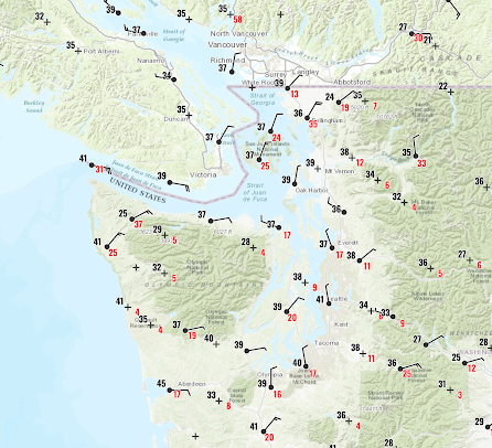
Cold air and gusty winds have surged southward into Washington State, with light snow over Northwest and Northeast Washington last night.
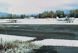
Snow was observed at Sequim Valley Airport northeast of the Olympics.
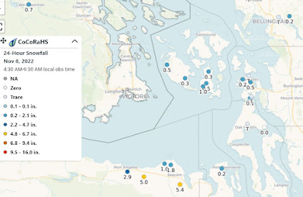
The snowfall totals, available from the cooperative CoCorahs network, showed about a 1/2 inch over the portions of the San Juans and 1-5 inches from Port Angeles to Sequim. There were some flurries over Seattle last night.
As the Fraser River outflow is forced upwards by the Olympics a band of precipitation (snow) is apparent on the radar (see example around 7 AM this morning)
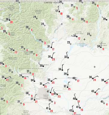
And let's not forget eastern WA, with cold, northerly winds, gusting to 25 mph, pushing southward out of BC through the Okanagon valley (see below)
This cold wave is quite a shock to the system.
It was less than a month ago (October 18th) when we almost hit 90F (see plot). During the past few days, our maximum temperature is barely reaching the normal low.
The average temperature for the past month is nearly normal 😆, illustrating the dangers of averaging weather over time.
To illustrate, here is the last graphic from the USDA snotel website.
WOW. The Olympics are over 2000% of normal and the Cascades 300 to 1000% of normal.
Snow heaven. Streamflows are generally near normal, by the way.
The next few days should be cool, often sunny, and dry as high pressure moves in.
We need the break.


Since we're getting this cold and snow now so early in the season could this be our "winter" or is this just a prelude to our real winter?.
ReplyDeleteIt's Fall, and a La Lina year. What do you think Tim?
DeleteWhat I always find interesting is the psychology of those who love weather. You can tell a 'fun' meteorologist by the words they use describe interesting weather phenomena, even in the neutral NOAA reports. I grew up in FL and the excitement flared palpably in one well-known TV meteorologist when hurricanes approached. Looking forward to an 'interesting' winter 2022-23. Hopefully we get more events such as this week's (I'm in PA) as we preluded to our la nina winter, if it so continues!
DeleteYes. Florida has many kinds of interesting weather. But 99 percent of the time, we only have three kinds: Sunny, cloudy without rain, and cloudy with light rain.
DeleteShortest fall I ever saw around here. We needed the rain, but now we have to acclimate to cold, dry air. Yuck!
ReplyDeleteI think you could do a really interesting piece/podcast on cold temperature averages as they relate to USDA growing zones for horticulture/gardeners. Plants are labeled as safe to plant by "zone" and Seattle was last labeled Zone 8B (meaning our lowest avg temps are 15-20) though actual averages since their 2012 release show we should probably be rated Zone 9A. Either way would be interesting to hear your thoughts on their system and if you would make any adjustments to factor in winds, microclimate etc.
ReplyDeleteCrazy snow number totals on that map. I'm here in the Columbia snow belt of Revelstoke and we have almost no snow; everything went south. Long range is looking cool and dry around here after an abrupt switch from warm and dry.
ReplyDeleteCliff, would you like to do a piece on why the winter cool-down is usually faster than the spring warm-up?
ReplyDeleteThat would be a very interesting one: I was just looking at yearly temp curves earlier, and noticed how some places have more skew to the temperatures.
Delete