Temperature contrasts in our region can sometimes get very large and this week we had some dramatic examples.
We are talking about as much as 50F in variation across the region during the morning
Consider the minimum temperatures on Wednesday morning. A buoy off the coast measured 46F and the temperature dropped to 44 F in the Strait of Juan De Fuca. In contrast, over NE Washington the lows fell into the single digits and plummeted to -2F in the Methow Valley near Twisp.
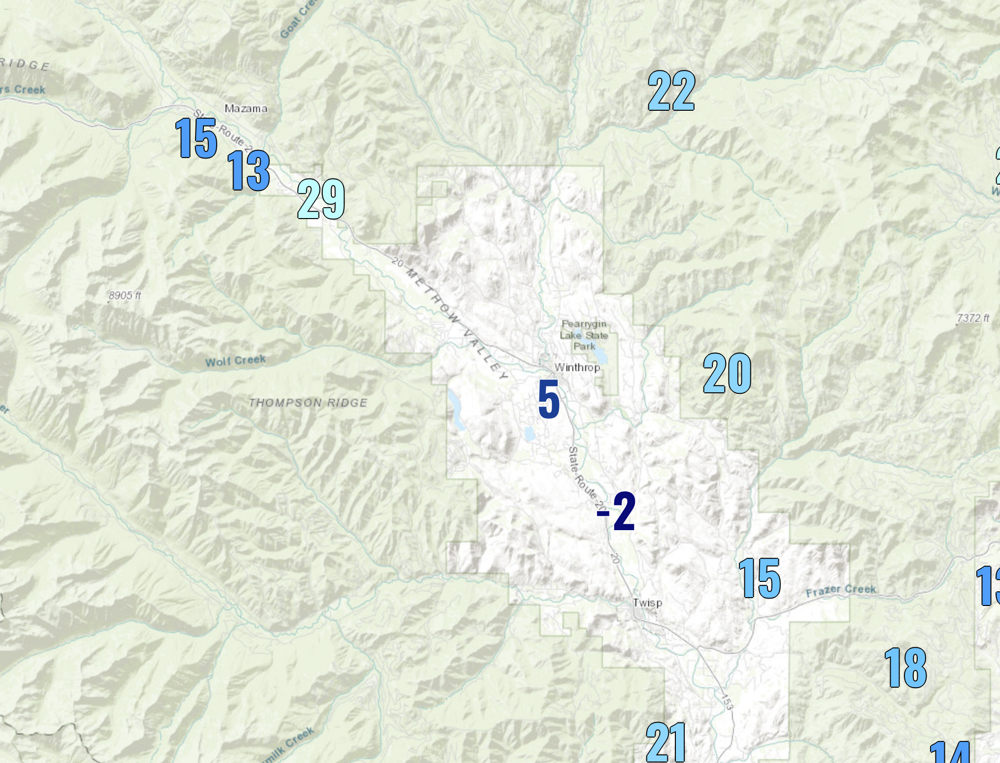
Here is a close-up view of the temperatures around the Methow Valley Wednesday morning--very low temps near the Methow Riber, but 10-20 F warmer on the ridges overhead.
On Thursday morning it was even colder in the Methow Valley, dropping to -5F, while temperatures were about the same along the WA coast.
How can we have such crazy contrasts over the region?
The first is the proximity to the relatively warm Pacific Ocean. As shown below, temperatures right off our coast are 12 C (54F) and warmer. Thus, if there are onshore-directed winds, the coastal zone stays relatively warm. The Cascades limit the eastward extent of the warm Pacific influence.
Then there is snow. Last week snow fell over the northern parts of eastern WA and snow coverage is still in place (see the visible satellite image this morning, which clearly shows the snow.
Snow really enhances cold. It reflects the warming rays of the sun and is a VERY good emitter of infrared radiation to space. The Methow Valley is now snow-covered.
Finally, the cold areas of the Methow Valley are, well, in a valley, as shown by the topographic map below. The coldest air is dense and heavy and tends to settle to the bottom of the valley.
A Google Earth 3-D image looking north from Twisp towards Winthrop shows the valley clearly.
The Methow Valley is the freezer of Washington state and the all-time cold record for the state (-48F) was observed in Winthrop.
And I almost forgot: this valley enjoys cold records for one more reason: it is high enough to be out of the low clouds that often fill the Columbia Basin. Clouds act as a blanket and prevent the coldest temperatures.


It's not Winthrop, but I felt completely blind-sided by this first cold snap. Was hoping for a more Hawaiian-based atmospheric river before diving into winter. Fall this year: Only three weeks long!
ReplyDeleteWould easterly flow also help to bring less moderate continental air into the area?
ReplyDeleteRelated question: I was looking at the chimney smoke of houses in the valley all spreading out at the same height, and wondered what determines inversion layer height. Is it simply how much cold air rolls into the valley as it's cooled by the ground after sunset?
ReplyDeleteThis is fascinating. Are those low temp maps available to the public? As a botanical gardener in West Seattle it's extremely helpful to understand microclimates especially as they relate to low temperatures.
ReplyDeleteAlso curious about the effects of Puget Sound waters on the islands and Seattle coastal areas. Does the warm pacific ocean effect help those areas remain more mild, or is that effect lost by the time that water reaches Elliot bay and Alki beach?
ReplyDelete