Climatologically, the Northwest is now in the wettest time of the year. But that is no guarantee of cloudy, dripping skies.
Today will represent the 13th day without measurable rain at Seattle Tacoma Airport (measurable rain is 0.01 inches of rain or more).
And in doing so we tied the record string of 13 dry days in November at SEA that occurred in 2000.
Tomorrow will be dry as well, and thus we will break the November record for consecutive dry days..
But to deflate your excitement a bit, this only ties the record that crosses over into December (November 20-December 3).
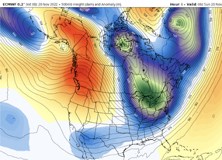
As noted, in earlier blogs, the origin of this dry bounty is a ridge of high pressure over the West Coast (see below), ironically resulting in headlines of cold/wet weather in the western U.S.
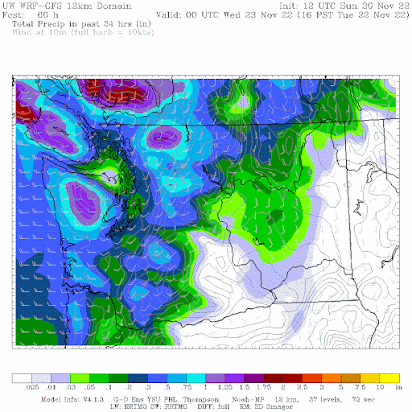
A front will break through the ridge on Tuesday bringing general rain over the region. The forecast map below shows the 24-h rainfall ending 4 PM Tuesday. No more dry records!
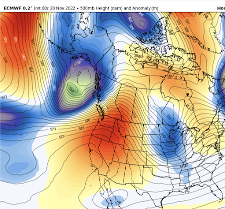
And then a miracle occurs. The ridge rebuilds late Wednesday and Thursday, leading to a dry, sunny Thanksgiving (see below). You can look forward to an invigorating pre or post-Turkey walk outside and safe travel across the Cascade passes.
But this won't last, a major shift to cool/wet conditions will still occur next weekend...more on that later.


I've read that long range models show a drying trend for December. Any truth to this?
ReplyDelete"Location, location, location" matters immensely, here on the west side. So far, near Mt Baker, this new rain year's actually looking quite a bit like RainYear 2019-20 to me (so far). We've had 9.03" Oct-Nov, through today Nov 20 - and we may exceed that if "incoming" is as heavy as the earlier two 2"+ deluges we had Oct 31-Nov 1 and the following days. So far, at least here, it's rained 35% of the 51 days - and this is "headwaters zone."
ReplyDelete"Climate wise" IMHO (49 years of observation in this spot), even though there have been some dry stretches, every indication is that this remains "Mediterranean" climate pattern, albeit at the dry end of the normal range. Those earlier deluges dumped snow in the mountains, and the Mt. Baker Ski Area opened a week earlier than they traditionally do (Thanksgiving weekekend). The clear, dry days have resulted in very cold daytime temps and overnight lows (little snowmelt). Without typical wet-precip rainfall, there's little 'stormwater' (runoff) which throws the river-flow tealeaf analysts, IMHO.
It's not "growing season." If this year plays out as I suspect it could - warm rains returning thanks to Pineapple Express events (like what I see coming, satellite vapor images) - we may catch up to "normal" quite quickly. Just a couple of weeks ago there were flood warnings. Then people started counting dry days as-if that's some pattern. Well, look back just a few years and, well... This is weather, NW style - IMHO.
Hi Cliff, could you please do a blog about why the forecast for the storm today was so badly wrong for the east side of the Cascade crest? The models/forecasts were predicting that the snow level over Snoq Pass would be ~5000ft and therefore rain would affect the pass with some light freezing rain over the Cle Elum area.
ReplyDeleteHowever, around 11am on 11/22 light snow began falling in Cle Elum with temperatures below freezing and heavy snow across the pass extending to Exit 47 Denny Creek. This went on for several hours resulting in many inches of snow which stuck to the road ice from the freezing rain. Even at 2pm weather.com was predicting this would quickly switch to rain and warm air to move in. However at 2.30pm another band of showers developed from the pass through Cle Elum resulting in blizzard conditions and many accidents across the pass. I was sitting in this traffic since i believed the forecast and after a few hours had to turn around.
I recall you have spoken before of the tendency for the models to mix out existing cold air too quickly but I would think forecasters should be aware of this and compensate. Anyway, id love to understand what happened and what can be done to improve the accuracy of these forecasts which would surely prevent road accidents since many were caught off guard since driving in rain is very different to a blizzard settling on a surface of black ice. Thanks!