There is an apparent contradiction regarding wildfires and climate in the western U.S. that few have talked about. Wildfire acreage has been low even though the summer has been warm and dry for most of the region.
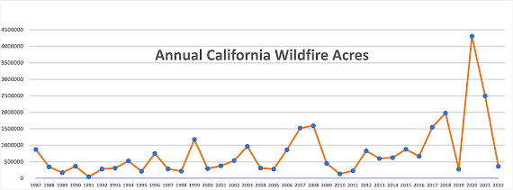
This year was one of the most benign wildfire years in a long time for the entire West Coast. Plotting the wildfire acreage over California since 1987 (see below) shows that the 2022 acreage burned has been quite low, similar to the situation 30 years ago.
And the same has been true for Washington State (below, from 2002 to now). The wildfire acreage this year was very modest...similar to 20 years ago.
The interesting thing is that this low-fire area situation occurred even though the west coast states have been warmer and drier than normal.
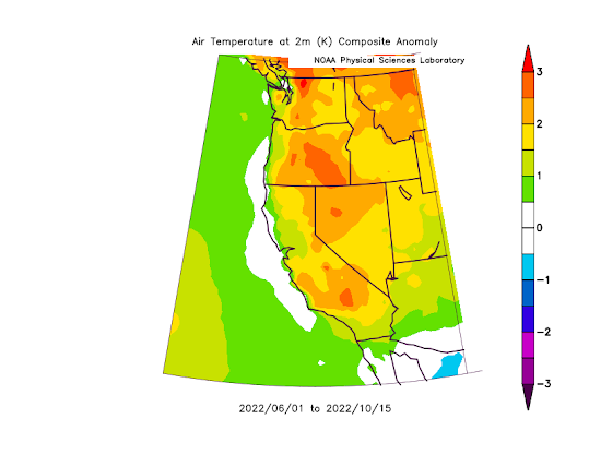
Consider the difference of this summer's (June 1-October 15) temperature from normal (1990-2010 mean)--see below. Warmer than normal for the entire coast! You would expect more fires--right?
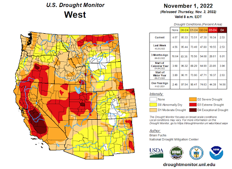
What about precipitation and drought? Well, folks like to look at the NOAA Drought Monitor, whose November 1 graphic showed terrible drought over California and eastern Oregon, and modest drought over the rest.
You would think this would encourage bountiful wildfire!
But it didn't.
How could this be?
It turns out that wildfire occurrence is much more complicated than the simple relationship between wildfires, temperature, and precipitation portrayed in some media and by some politicians.
Let's confirm this by plotting the average temperatures, precipitation and wildfire acreage over Washington from 2002 to this year (below).
2022 had the warmest summer (June through October) for the entire period by far.
And this summer was much drier than normal... the driest summer in 15 years!

But yet the wildfire acreage was very low..... again, how can this be?
The Connection Between Wildfire and Weather/Climate is More Complicated Than Often Portrayed
The connection between climate and wildfires is far more nuanced than some folks suggest. And that means the connection between global warming and wildfires is not as definitive as often claimed.
For example, strong winds are an essential component for initiating and spreading wildfires. And strong easterly winds (such as the winds that spread the recent Bolt Fire near Skykomish) are particularly important for wildfire on the western side of regional terrain barriers.
The lack of strong easterly winds this summer and fall helped keep down the fires this year. And recent research suggests that global warming may REDUCE such winds for the entire West Coast, reducing fire initiation and spread. You won't hear about that in the Seattle Times.
Most West Coast fires are initiated by humans, with poorly maintained electrical infrastructure being a major contributor. Substantial recent efforts have been given to trimming trees near power lines, hardening electrical infrastructure, and de-energizing powerlines when strong winds are forecast. This seems to be helping.
Finally, the dry conditions last winter reduced the amount of fuels available, particularly grasses, thus lessening the potential for fire.
Warmer temperatures and drier conditions do not necessarily increase fire risk significantly. The West Coast has a Mediterranean climate with very dry summers. Even a normal summer allows surface fuels (such as grasses and other light vegetation) to be dry enough to burn. Once you cross the thresholds of dryness, being a bit drier makes little difference.
And there are many other factors modulating wildfire area other than weather and climate. For example, poor forest management and suppression of fires for 75 years produced forests primed for a catastrophic fire. Invasive flammable grasses have increased fire threats, as have increased human ignitions. New "let it burn" directives are increasing fire. On the other hand, once there is a fire, the area is less likely to burn for a while.
In short, the relationship of wildfire area to weather or climate is complex with many other important--if not MORE important....factors other than climate.
The Latest Forecast in My New Podcast: Dry, La Nina Conditions Ahead
Some major podcast servers:
Like the podcast? Support on Patreon


I would be curious to see a graph of annual biomass burned, instead of acreage - since I assume the same acreage with much higher biomass would put a much larger portion of particulate matter in the air. For instance, many of the largest fires in eastern Washington burn through grass and sagebrush and are pretty much over in a matter of days.
ReplyDeleteFantastic point. I'd love to see that comparison too.
DeleteI don't think data is collected on that statistic. It does seem that a higher percentage of acres burned were on the west side of the Cascade Crest this year (although I don't know that for sure), and the biomass is certainly more dense on the west side.
DeleteI don't understand. We've always been told that La Nina means the Northwest will be cool and wet. But from your podcast, it sounds like La Nina is a recipe for continued and frequent drought. So which is it?
ReplyDeleteLa Nina typically results in cool, wet conditions in Washington in the Winter, but to the south it produces drought.
DeleteThis is the ridge that doesn't end
ReplyDeleteYes it goes on and on,.my friends
Some people love the winter sunshine not knowing what is was
And it will continue to be dry and sunny forever just because.
Unless you are being facetious, that is not true, and he later posts that this ridge will not last beyond this week and the rains return next week.
DeleteI am completely unaware of any "let it burn" directives for any state or federally managed lands. Why do you think fires are being "allowed" to burn? Fires are still aggressively suppressed almost anywhere it is safe to do so, and firefighters are still being killed in the line of duty every season.
ReplyDeleteCliff, looking at the two graphs of wildfire activity, my read is that there is a lot more white space under the graph lines as you move right. In other words, over the time period there has been more fire activity as we get closer to now. That we had less fire activity this year doesn't, at least to me, make the case that there hasn't clearly been more fire as the world heats up and dries out. What am I not understanding? Thanks for your great blog.
ReplyDeleteYou are correct to say there are other factors other than a warm, dry summer that influence the amount of fire and acreage burned during the fire season. One factor you did not mention, which is of major importance in the east of the Cascades forest areas, is lightning. Lightning has been the main instigator of most of the large forest fires in this area in the past 30 or 40 years. Most of the Lake Chelan trench on both sides from Stehekin down lake to Chelan has burned due to several mostly lightning caused fires. The same is true for much of the Pasayten Wilderness, and most of the big fires in the Methow, Entiat and Wenatchee valleys plus others south of this area were lightning caused. Most of these big lightning fires occurred in warm, dry summers such as 1970, 1994 and in the recent summers of this century. The type and timing of lightning is critical to fire starts as lightning occurring after a cool, moist period or if accompanied by rain seldom causes fire problems; fuels are too wet to ignite. It is the dry lightning storms, especially those during our warmer, dry summers that have resulted in the largest fires. This past summer did not have much lightning in most of Eastern Washington but the dry storms that did occur, mainly over and just west of the Cascade divide, caused more than the usual number of fires in that area, because it was so dry.
ReplyDeleteMost wildfires are "caused" by humans, accidentally or on purpose. This is the wild card. While weather conditions contribute to the severity or chances of a Wildland fire starting, the ignition factor is usually man. Not in all cases, but most.
ReplyDelete(I already commented about the relationship of lightning to fires in Eastern Washington, so you may not want to post this comment, but I did want to illustrate a possible relationship between warm, dry summers and acres burned.)
ReplyDeleteYou say correctly that there are other factors than warm temperatures and lack of rain that contribute to acres burned. However, there has been a pretty good relationship between these factors in Eastern Washington this century. I looked at the six greatest fire loss years shown in your chart for this century (2006, 2015, 2017, 2018, 2020, 2021) and compared the average summertime (June thru August) maximum temperature and precipitation at Wenatchee Tree Fruit Research Center for those years, with the corresponding temperature and precip for the six lowest fire years (2002, 2004, 2008, 2009, 2010, 2011). The average summer max. temperature for the six greatest fire loss years was +4.1 degrees above normal and precip. was 18% of normal. Temperature for all months of these six large fire years were above normal and all but one month had below normal rainfall, and every July was rainless. For the six low fire loss years, the average summer temperature was +0.5 degrees above normal and precip. was 50% of normal. 12 of the 18 summer months of these low fire years had above normal temperature and all but three months had below normal rainfall.
I realize that this comparison between one station and the fire stats for the entire state may not be quite valid, but I think you would find that much of the burned acreage was in Eastern Washington during these years and quite a bit of it in North Central Washington, so Wenatchee data may not be a bad indicator. The normals that I used for Wenatchee TFRC are for the period 1940 to 1993.
My conclusion looking at this is that there is a pretty good relationship between warm dry summers and acreage burned, and even during the low fire seasons temperatures have been warm and rainfall lacking this century compared to normal. Also, even though this past summer did not see a large fire loss, there has been a trend through this century of increasing fire loss, with 5 of the 6 greatest fire loss years occurring from 2015 thru 2021, and all of the lowest years occurring on or before 2011.