A huge amount of weather has occurred and we are now within the high-resolution forecast period for the lowland snow event on Monday.
The atmospheric river of Thursday/Friday did not disappoint, with some locations securing nearly 10 inches of precipitation (see 48-h totals below). Several local rivers reached flood stage and major regional reservoirs have begun to fill.

It is probably time for the US Drought Monitor to drop the SEVERE drought over western Washington
😊

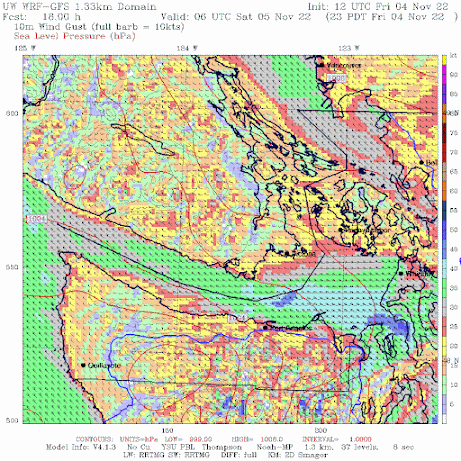
The warm/moist atmospheric river situation was ended late Friday by the arrival of a powerful cold front moving in from the Northwest.
Behind the front, a very strong westerly wind surge pushed down the Strait of Juan de Fuca, with winds reaching 60-70 mph, resulting in tens of thousands of customers losing power in the north Sound area. Our WRF modeling system provided an excellent forecast of the wind event (see below, blue and light blue are the strongest winds)).

OK...there has been lots of intense, interesting weather the past few days, but what many really want to know about is whether there will be lowland snow.
And the answer is yes...but it will only be in certain locations. Interestingly, the problem won't be cold--it will be precipitation!
On Monday, a powerful current of cold, northwesterly winds will push out of the Fraser River Valley across Bellingham and the San Juans, then push into the Olympics and out the Strait of Juan de Fuca (see below, blue colors indicate temperatures cold enough to snow).

And by Tuesday morning, some of that cold air will push into Puget Sound (see below)

Now let's look at the accumulated snowfall through Tuesday morning from the UW high-resolution model (see below). Huge amounts in the mountains (feet). Several inches from Bellingham to the San Juans. Snow at low levels along the Strait of Juan De Fuca and east or south of the Olympics....and even a few flakes over north Seattle.
An important factor working against the snow is easterly downslope flow on the western side of the central Cascades and the general lack of general precipitation because the strongest atmospheric forcing will be south of us. Will watch the evolution closely.

PS: On Friday I did not bike to work because I feared falling trees from the winds. Driving along San Point Way, I saw a huge branch fall around 5:45PM, hitting a powerline, causing a fountain of sparks, and then knocking out the power. Including my home. You really have to respect and appreciate the linemen/linewomen that go up into the lines to restore power.


Dr. Mass: Assuming the models are correct and snow makes it down to sea level, will this be the earliest occurrence on record for our area?
ReplyDeleteNot Cliff, but I grew up here, and I believe it is the earliest as we don't typically get any snow, nor forecast of it before Thanksgiving. That said, I could be wring.
DeleteI grew up in the Seattle area, and when I was little (1971 I think) I trick-or-treated in the snow. Not sure if that was the earliest snowfall for Seattle, but I don't think we've had snow that early since then.
DeleteI have a vague recollection of seeing a dusting of wet snow on Halloween morning during the mid 80s. I also remember a huge snowstorm occurring on November 17th (I believe 1985) where we got 17" in Federal Way.
Delete"Our area" was probably a little too vague an ask considering the large variability in snowfall over our very complex weather region. Way more complex than the Great Plains I would think! Thanks for the different insights.
Delete@ DC. 1985, the snow hit on the 21st and 27nd of Nov that year. I was a young 20 YO buck living in Tacoma with my parents at that time.
DeleteHi Cliff 👋
ReplyDeleteWill we get any snow ❄️ here in Downtown Greenbank on Whidbey Island ? 🤔
Last evening, the heavy-duty rain and winds hit S. Everett...in the a,m, I looked out my back window...the fence between my property and my neighbor to the East, had blown down!..No real damage to anything other than the fence..My landlord will not be too happy about this!
ReplyDeleteSo fix it... it's a fence
DeleteWhile yesterday was nice and sunny much of the day, Friday, it was wet, wet, wet, and it's wet this morning, though it looks to have let up now at 8:14AM. It'll be interesting to see how the day tomorrow progresses as I have a job interview in the afternoon at Tacoma CC, mid afternoon.
ReplyDeleteIt's plausible that Kitsap stays in the drought rankings for a while but on the long term that area, especially the further southern areas, receive more rain overall than across the Sound in spite of a slightly shorter rainy season. When the weather patterns shift in autumn and spring, Kitsap always gets an intense rain shadow those transitional weeks. Which brings up the question of why TV news always predict unreasonable rainfall totals when historically it's always been nill or close to nill when the weather flows directly west to east.
ReplyDeleteSnowing here in Port Angeles at 500 feet this morning. Slushy, but about half an inch on the ground...
ReplyDeleteFriday night on South Whidbey outside of Langley we got 60 mph bursts and the alders on our property went down like toothpicks, several being mature tress. There were extensive loss of trees on the island and most lost power with many yet to regain it. One of the worst blows in the last twn years.
ReplyDeleteThe fact that so many trees still have leaves due to autumn being "skipped" probably was a big factor in the windstorm carnage. Kinda glad the snow is not going to happen as well, due to trees such as alders still being fully foliated.
ReplyDeleteSo why wasn't there a convergence zone downwind of the rain shadow?
ReplyDeleteYes, it would be nice if those silly cottonwood trees were not so slow about dropping their leaves. They start as early as late August, probably because of the drought, but don't finish until typically the first week of December. Makes yard cleanup difficult.
This comment has been removed by the author.
ReplyDeleteBrief thunderstorm last night with hail. On the Bothell-Mill Creek line. Must be the cold front.
ReplyDelete