Now well into December, with the holiday break only two weeks away, many are thinking about our mountain snowpack. Is the outlook good for skiing and winter recreation?
I think I can give you a realistic answer at this point.
Let's start with the current situation, examining the percent of normal snow water content around the western U.S. (see below).
The situation is quite favorable right now. The snowpack is well above normal (150% and more) for the northern Sierra Nevada, Nevada, and most of Oregon. Washington State is doing well, with central and southern Cascades above normal.

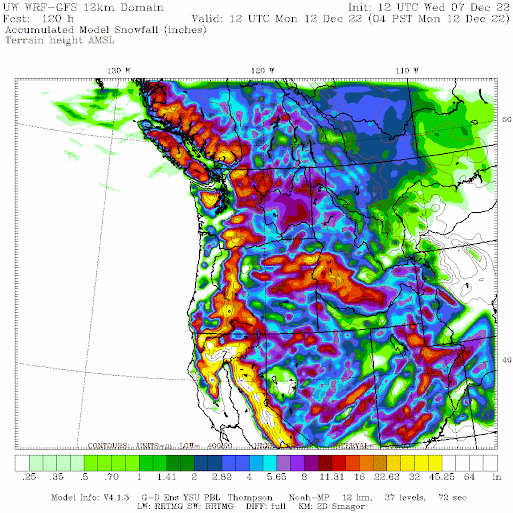
And folks there is more coming! The UW model forecast of total snow accumulation over the next 5 days is shown below. Healthy snow accumulations for the entire West Coast, with particularly heavy snow over the mountains of California. This is good for water resources and lessens the fire chance now and in the future.
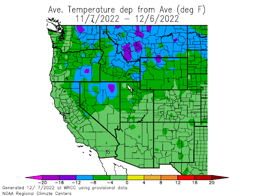
This is a La Nina winter and the typical La Nina atmospheric configuration is in place, with a big ridge of high pressure in the eastern Pacific. This ridge has been very persistent. A ridge offshore produces cool, northwesterly flow over the Northwest, and we have certainly been much colder than normal over the past month.
To illustrate, below is the temperature difference from normal for the past month. The whole west has been colder than normal, with northeastern Washington and Montana WAY colder than normal. Blame La Nina.
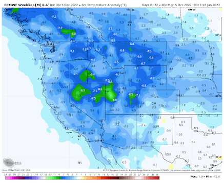
Here is the latest prediction for the next 30 days from the European Center model. Wow. Colder than normal conditions over the entire West! Makes one want to stock up on hot chocolate and marshmallows.
With a good snowpack in place, more coming, and cold temperatures predicted, I think decent holiday winter recreation is almost guaranteed.


Dr. Mass, in the past you have always suggested the effects of LaNina don't start until after Jan 1st. Now it sounds like you are saying we are in a LaNina situation.
ReplyDeleteCliff, I have always wondered, why the USDA Snowtel site excludes the mountains of California on there SWE page?
ReplyDeleteYes, it IS winter. Time to take it seriously, and heed warnings. I90 has been shut down WAY too often due to blatant ignorance, stupidity and outright ignoring the fact that slowing down is important. People dying from running generators inside, etc. Please, stop popping the stupid pills at breakfast time and be safe!
ReplyDeleteCurious what your thoughts are on the water supply forecasts? The NW RFC has the Jan-Jul at 80% for The Dalles, despite the above normal snowpack conditions. Soil moisture initialization and water year precipitation (both estimated/measured below normal and notably lower than swe) are likely the main drivers. Probably too low at this point? Still a lot of time remaining in the water year, but it is interesting how much lower the water supply forecast is vs snowpack and time remaining in the water year.
ReplyDeleteWell, if you watch Casey Ladell on YouTube, he lives near Bend and that whole area is deep in the snow right now, so I would expect the Dalles area to be similar. A video from a day or so ago had him up in the mountains to pull out a truck that slid off the road. The roads have quite a bit of snow on them and once you get off the main roads and into the off road areas and trails, the snow is very thick, like over a foot to several feet.
DeleteHe earlier this week, I think it was, he uploaded a video where he took his CJ6 Jeep, equipped with tracks and a couple off men in a 4WD truck to go rescue a couple at a fire watch tower as they got stranded as a snow storm unexpected blew in a day early as they had planned to leave that morning when the storm hit and had to be rescued. So there is a lot of snow in the Oregon Cascades already. Casey does heavy tows and rescues on his channel.
Thanks Cliff.
ReplyDeleteCurrent temperatures in Kittitas County are reasonable; colder 2 weeks ago.
The icy fog led to a 38 vehicle pile-up on I-90 near Kittitas.
This morning there is a fine particle snow – again. Pretty winter scenes.
The Snotel SWE map has a basin along the Oregon coast as 1567%.
That must be programming/mapping error.
The source regions for Columbia Basin irrigation water and hydro-power look healthy, especially if the parts in British Columbia area assumed to be above average.
Looks like the heart of the cold is to our east but still cooler than normal here, no artic blast in the foreseeable future for western Wa.
ReplyDeleteWhat does La Nina mean for the Colorado River drainage area? Any chance of an exceptionally wet and snowy winter there that would help to significantly raise the water levels of Lake Mead and stave off the possibility that Hoover Dam would no longer be able to generate electricity?
ReplyDeleteI'm no expert, but Colorado snow trends to be less during la Nina, although spring snow could always be heavy. Unfortunately it doesn't really matter as the outflow from Lake mead is significantly greater than even a heavy snow year can help with.
DeleteWhat does the next system have in store for the Hood Canal environs ?
ReplyDeleteIs it marginal or will the east winds give us more snow ?
From this headwaters perch I largely do agree that the 'snowpack' situation is very good at this point in the Cascades, but I think it's extremely important to note that IMHO - at least in the northern end of the Cascades - the quality (density and accuracy) of reliable data is not stellar. The USDA SNOTEL map for our zone (the zone that includes Mt Baker) is driven by just a few stations, and however well-intended USDA's placement of some of the stations, based on real-time observation of rain and snow some output (like the Wells Creek SNOTEL (909)) seems downright incredible (as, "not credible").
ReplyDeleteFor years Prof Mass has petitioned - advocated strongly and widely - for better and more dense data collection because principled scientists need real(istic) knowledge of what's really occurring, not just observation of atmospheric phenomena, but climate conditions overall. Forecasts and models are inherently GIGO (garbage in, garbage out) and there's precious-little observation to go-by over large swaths of uninhabited areas. Radar and satellites have become impressive and sensitive, and I very much appreciate the suite of "observation" data at the UW Atmos site - look to that quite often. But the capacity of these methods to accurately measure ground-level activities, most particularly snowfall (density) and snowpack, are "birds eye" and limited. There are very - very - few SNOTELS, and I know that (at least the local one) clearly miss recording and reporting significant events when weather swirls, curls, and doesn't follow what may have been the site's anticipated "prevailing" wind pattern. As "all weather (and frankly climate) is local," ("micro"), the sparse SNOTEL network leaves a lot to be desired, again IM very HO.
Near Mt Baker, we had our "first snow" very early this year, November 7. As of today, Dec 11, the ski area reports a credible 79-96" snow base (envision that in feet: 6.58 to 8 ft) on the ground. I think the 12/7 SNOTEL map's 94% of normal for the Mt Baker zone is under-stated, "light." Why? I think Wells Creek SNOTEL 909 (sited in 1985) may report what the instruments sense, true - but it's turned out to be in something of a rain shadow (all seasons). I can't - and won't - begin to guess at the credibility of the rest of the USDA SNOTEL data, but I sure don't take their weekly maps as scientific gospel, and it concerns me that so many look to the SNOTEL data for policymaking.