There is no weather situation that I love more than the one that is occurring tonight. It is quintessentially Northwest.
After a period of warm weather, a surge of marine air moves inland, bringing substantial winds and a rapid cool-down.
Best of all, the entrance of the onshore push of marine air is signaled by wind chimes, which are now sounding all over my neighborhood (play the video below!).
Low clouds off the Pacific Ocean are now pushing inland, as indicated by the visible satellite image at 6PM.(see below). But this banquet of weather doesn't stop there, as unstable air over our region is associated with cumulonimbus clouds and thunderstorms moving westward, particularly over southwest Washington and Oregon (see visible satellite image).

During the day on Monday, a key measure of the potential for an onshore push of marine air, the onshore pressure gradient, rapidly increased. My favorite pressure gradient for pushes is the Hoquiam -Seattle pressure difference; when it gets to 4 hPa (hPa is a unit of pressure), a strong push of marine air is inevitable over Puget Sound. Late Monday afternoon it got to 5.2 hPa! (see the plot below). The die was cast.


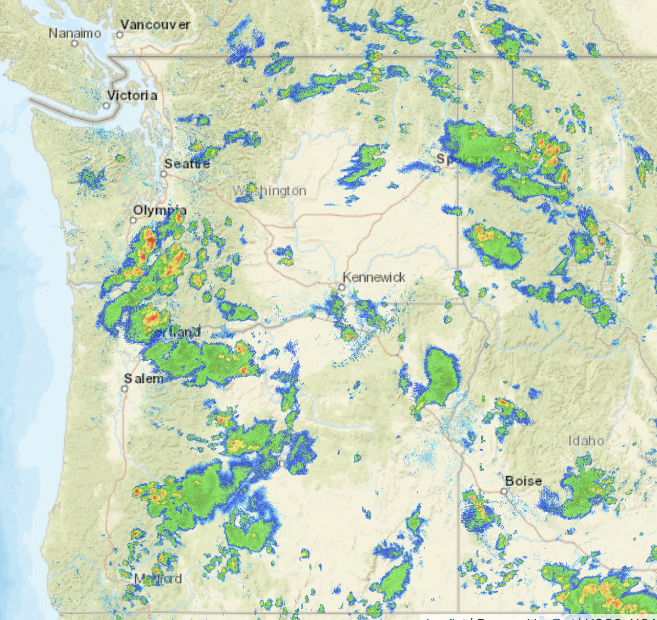
The radar image late this afternoon and evening is all lit up with strong convective showers, particularly between Olympia and Portland, but east of the Cascades got a piece of it (see radar at 5:43 PM below).
As I write this around 9:20 PM in Seattle, I can hear thunder in the distance. In fact, the 9 PM satellite-based lightning mapper shows lightning strokes just to the east of Seattle (see below).

The change in our weather is associated with the weakening of high pressure/ridging to our north and the movement of a weak upper-level low into Oregon (see below). Cold air aloft contributes to instability and thunderstorms since air parcels can become unstable (and thus mix vertically) when the temperature change with height increases.

So if you are living west of the Cascade Crest, open your windows and be prepared for a good night's rest. Cool air and some thunderstorms? What could be better?
.
East of the Cascade crest, you might see some more thunderstorms tomorrow!
In any case, the several days of much above-normal temperatures are over.
____________________
Interested in a free lecture at the UW on How We Will Stop Fossil Fuels From Causing Global Warming by Oxford University Professor Myles Allen? It will take place at 7 PM May 25 at UW's Kane Hall and you can get more info and sign up below. Professor Allen is a very good speaker and internationally very well known; the talk will probably fill quickly so make your reservation soon if you want to go.


At 11:10 pm in Bellingham about 1 mile north of the airport, my open windows moved with the change in wind speed and direction. Sudden change as the marine air blew in, it was "cool" lol.
ReplyDelete34-40mph winds at Lake Whatcom area last night. Crazy.
ReplyDeleteThat Lightning was sure cool last night! Some good rain too Northern Snohomish county
ReplyDeleteAbsolutely agree. Beautiful evening out here on the Peninsula (minus distant thunderstorms). Windows were wide open. Lovely.
ReplyDeleteThe daily mean temp of 71F on 5/15 was also the most anomalously warm daily mean temp for any May day on record at BLI: 15.6F above normal. The data for the month to date and the current forecast indicate that this month will likely be one of the hottest, driest Mays on record.
ReplyDeleteThe month is only half-done and cooler, showery weather is ahead.
DeleteWhat's your source on the temp data at BLI? A 55.4 mean for May 15th seems very low.
DeleteI stayed up till midnight because of the breeze coming in the windows and the wind chimes sounding!
ReplyDeleteMore 80's Wednesday and Thursday, nice.
ReplyDeleteGot to ~91 degrees at my house on the Bothell-Mill Creek line yesterday. Then a few distant flashes of lightning and rumblings of thunder around 9:00-10:00 last night, with a few sprinkles, but not the excitement I was hoping for.
ReplyDeleteIndeed...here in S. Everett, it was "much ado about not much!"...a couple of far-off lightning flashes, no thunder, moderate wind, and just a few showers.(sigh).
DeletePlenty of lightning last night. We live about a mile north of Snoqualmie Falls, on the Tokul plateau. The Cascades are just one or two miles away. The lightning was about a mile north, in the foothills of the Cascades. Lots of rain also.
ReplyDeleteWe had an eerie sunset last night, and we just knew what was next. Happy to have what rain we could get, and happier still to hear that we might see cooler weather ahead.
ReplyDeleteYes!! Thank you so much for answering my question!! I knew it must have been some interesting meteorological phenomenon! Always appreciate your insight Professor Mass!
ReplyDeleteSo why does the sun have that yellowish wash-out look this morning? I sure hope it isn't a fire already!! Very high humidity does wash it out but gives it a more whitish color.
ReplyDeleteI must amend my last comment. The Canadian fire map shows numerous fires in Alberta already. I don't understand how it's possible. Six weeks ago there must have been snow on the ground that far north. How could a forest dry out that fast? They must have had at least some rain. Doesn't make sense to me.
ReplyDelete