Will do an update tonight on the potential for lowland snow on Friday/Saturday.
_______________________________________________________
There is a LOT of active weather ahead, some of it very challenging to forecast.
If you had any plans on crossing the Cascades, do it today. Most of the passes will be closed by blizzard conditions tomorrow.
And I would charge up your phones and other electronics today if you live west of the Cascade Crest.
A strong wind event over the western lowlands will result in many power outages later tonight and tomorrow morning..
The key feature over the next 24-h will be a strong low-pressure center that will move across southern British Columbia tonight and tomorrow.
Check out the pressure/wind/temperature forecast for 7AM tomorrow morning (below). The solid lines are isobars...lines of constant pressure.

A very large pressure gradient (difference) will develop over Washington State and this will produce strong winds.
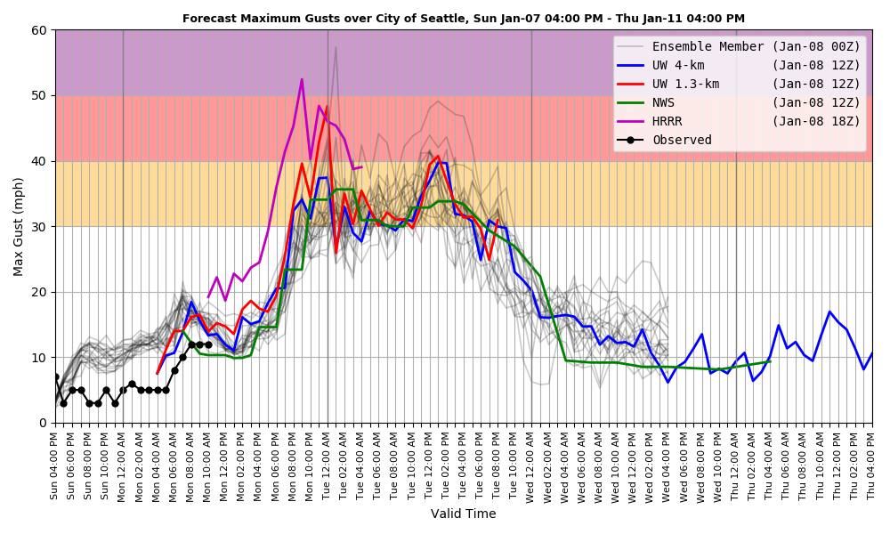
Let me show you the latest forecast from Seattle WindWatch, a sophisticated wind forecast system developed and run at the UW, with support from the city of Seattle.
This plot shows the maximum forecast gusts over Seattle from several prediction systems.
Wow. Wind this evening could easily hit 40+ mph in some Seattle locations, with winds remaining quite strong (from the south) all day tomorrow.

And then there is the heavy snowfall in the mountains. The National Weather Service now has a blizzard warning out....a good call.


Interesting
ReplyDeleteThanks for the forecast. It's going to be a fun few days. Friends in the Midwest are mocking me for having to "prep" for the temperature going below 20F
ReplyDeleteEl Nino not living up to its name currently, I thought for sure I would be mowing my lawn by the end of February but now I'm not convinced.
ReplyDeleteEh, you never know. We might have cherry blossoms by St. Patty's Day when this storm is nothing but a memory.
DeleteI was just commenting on this to my wife. There was a map that I saw somewhere recently that January was to be "much above normal" temperature-wise here in the Pacific Northwest. The first week was right around average, then this deep freeze moves in with temperatures 10 to potentially 20 degrees below normal for up to a week. I doubt we will see much benefit from El Nino temperature-wise for the rest of the month.
DeleteCliff is STOKED!!!!
ReplyDeleteThere won't be any snow. The only time we get a good snow fall the weather gurus say we're not getting a drop. Then when they hype scare calling for single digit Temps and 10" of snow it turns out being 40 degrees and rain. Been that way as long as I can remember
ReplyDeleteHere on the dry side (near Ellensburg) I got half or less of the snow and almost no wind. I think the wind is at a higher elevation. Now I am hoping the 5°F forecast is equally wrong.
ReplyDeleteBlewett Pass (Hwy 97) was closed because of wind, snow, fallen trees, and poor visibility. 17 miles north of me and 2,000 ft higher.
I have noticed lately that Cliff has become quite a bit more hesitant to venture out with his long range predictions as often as he has in the past. I felt that he was/is quite a reliable source in his 6 to 10 day forecasts. Am I correct? Or has it become increasingly more difficult to make these predictions as of late? Just curious🙂
ReplyDeleteIn my experience Cliff has always been tentative about making snow forecasts. The exception that proves the rule happened some years ago when he called our attention to a couple systems well into the future that he promised would bring all sorts of trouble, and sure enough.....
DeleteRon, you need to understand the nature of longer-term forecasts. The models make lots of runs with slightly different initial data. When those multiple runs converge, then the forecasters believe the results are a good forecast. When the models don't converge, then forecasters have low confidence. The reason for using slightly different initial data is that the data is never perfect and slight differences sometimes can have largely different outcomes. Snow forecasts are particularly difficult because it takes both cold air and moist air to create snow. Moist air comes from the Pacific and is rarely cold enough. Dry air comes from the inland (typically from the NE) and is rarely moist enough. Those two air masses must converge at the same time to create snow in the lowlands. Usually, one airmass is stronger than the other and pushes the other out of the way. If you have followed local snow reports in the past few years you will know that forecasting snow has become much better, mostly because the UW High Resolution Model. What surprises me is how often the forecasts are actually accurate including predicting the amount of snow in different areas around Puget Sound. Cliff's next post should provide a lot more information. So, it is not that Cliff has become more conservative in his forecasting, but that Cliff is accurately reporting the indeterminacy of the data in the forecasts.
ReplyDelete