Have you taken a look at the temperature forecasts on your favorite smartphone app or online service?
Most are predicting temperatures that are crazy warm by as much as 15-20F!
Yet, the National Weather Service forecasts are reasonable. Why?
Before I explain, let's review what is going on right now.
The latest satellite image shows an area of deeper smoke has moved northward over western Washington. Smoke has also moved into eastern Washington. Only the north Cascades is in the clear.
At low levels, marine air and low cloud have pushed into portions of western Washington. With more smoke aloft, solar radiation will decline over western Washington today, providing an infernal murk that is a bit depressing.

The current air quality situation is similar to yesterday afternoon with unhealthy conditions over the region and very unhealthy particulate levels at some coastal locations and the Willamette Valley. Hazardous condition are found in the Willamette Valley and northern Oregon. This is bad folks.

The good news for Puget Sound residents is that conditions have improved a bit over the past several hours (see plot): small particle concentrations (PM2.5) declining from around 170 to 130 at Beacon Hill in Seattle. I would avoid heavy exercise today, even if you are young and healthy.

I do have good news. The end is in sight for suffering residents of western Washington. But you have to get through today.
The latest NOAA/NWS HRRR forecasts for 4 PM today suggest that there will be only slight improvement today over western Washington (we remain in the darker red--over 100 micrograms per cubic meter of the small particles). Portland remains terrible and conditions are very poor east of the Cascade crest.

But increasing onshore flow on Sunday really will initiate a transition. MUCH cleaner air will push in by 4 PM Sunday over the coastal zone and will just reach Seattle late in the afternoon.

By 1 AM Monday, air quality will be hugely better in western Washington and the Willamette Valley, but those living east of the Cascade crest will be remain in the murk. Northern Idaho and western Montana as well.

Smoke causes surface cooling and ruins automated forecasts
The wildfire smokes has a profound impact on surface temperature, causing cooling by reflecting the sun's rays back to space and absorbing some of it aloft. That is probably obvious to most of you from being outside yesterday, but consider the radiation measurements on the roof of my building at the UW (see top panel below). Much less radiation yesterday (a drop of 22% from 19.83 to 15.49).
The temperature plot is shown right below-- highs dropping from 95 to 73.


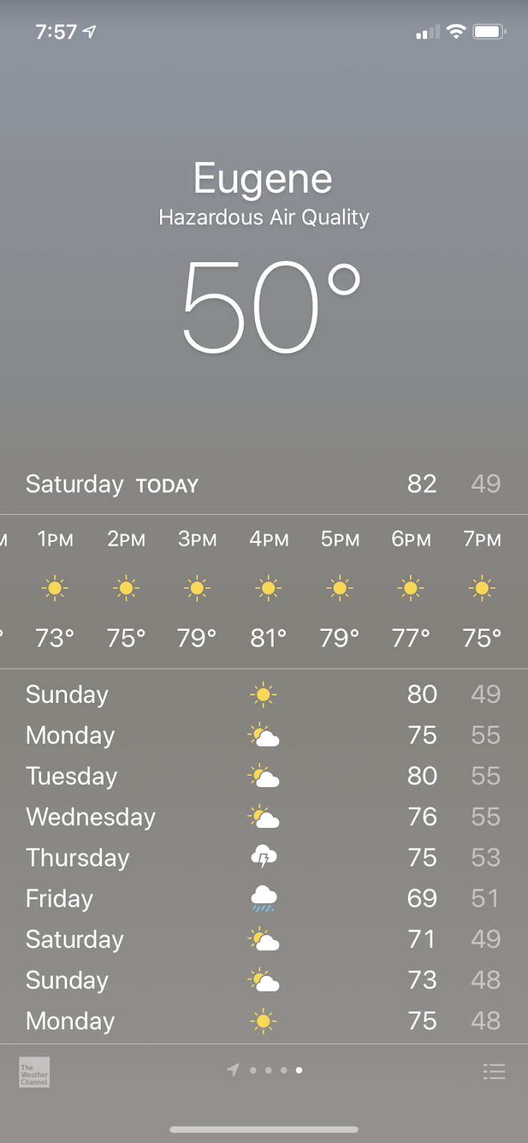
Now here is the problem. Most weather prediction systems are not including smoke and thus are missing its profound cooling effect. Thus, their forecasts are too warm--and too warm by as much as 20F in areas of dense smoke. On my smartphone right now, Portland is predicted to get to 79F and Eugene, OR to 82F. In truth, they won't get out of the 60s. These forecasts are coming from Weather.com.

The automated services are all too warm because the modeling systems on which they are based do not include smoke. That is also true of many of the National Weather Service models. The NOAA/NWS HRRR smoke modeling system is still experimental and will go operational this year. And I expect all modeling systems will include smoke within the next few years.
This situation shows why it is good we have skillful human forecasters minding the shop at the National Weather Service: they are manually correcting the model predictions so that accurate forecasts are still available.
_______________________
My latest podcast:
Become a Patron!
The podcast is also available here:
Anchor: https://anchor.fm/cliff-mass
Apple:https://podcasts.apple.com/us/podcast/weather-with-cliff-mass/id1530589673
Spotify: https://open.spotify.com/show/4VsGQeUSx5dvv5J9Kui4uh
RadioPublic: https://radiopublic.com/weather-with-cliff-mass-WkR0Md
Pocket Casts: https://pca.st/sgzd52am
KNKX and Cancel Culture is found here.


Thanks again for your helpful updates. Guess we can’t get rid of the humans entirely at NWS luckily.
ReplyDeleteIn Vancouver, WA, we are in day 5 of the murk and very glad that actual temps are lower than predicted temps. When it finally rains, I will dance in it.
ReplyDeleteWith "The automated services are all too cold because the modeling systems on which they are based do not include smoke. " did you mean to say the services are all too HOT? if smoke has a cooling impact? Confused.
ReplyDeleteThanks Cliff! Great stuff...
ReplyDeleteThe AQI varies wildly based on your elevation, according to what we are experiencing. We are about 475 feet in east auburn (along the auburn/kent line, lea hill area).
ReplyDeleteThe downtown Kent AQI sensor was showing 180'ish this morning, but we were getting 260 AQI at our house at the same time. Also, we are seeing people taking pictures of sun (at various colors), but we can't even see it at all. Same with last night, was hoping for a orange glow, but there was nothing at all, looking straight at where the sun was suppose to be, we couldn't see any glow). Today everything is yellow and the smoke is worst point it's ever been in terms of visibility.
So I really think just a couple hundred feet elevation makes a massive difference in AQI and smoke density, making it impossible to check actual AQI based on the sites like airnow.gov, etc.
We have 2 PM 2.5 sensors that we use and have been comparing them to the sensor stations that are in the kent valley area.
Thanks.
ReplyDeleteI've noticed that about the temperature being lower than forecast several times in the past few years when we have large smoke cover. A mixed blessing, as the air is not blazing hot, but we still don't want to go outside.
ReplyDeleteI live in Pasco, and the Kennewick Metalline station was reporting 828 in my aqi app (though my link to the web page for it has a dial that maxes out at 500. 🤔)
Anyway, my brother works for Columbia Crest winery. I relayed to him your comment about hoping the grapes are harvested. Alas, harvest is just beginning and we won't see him for a couple months. He did comment that this year's vintage might have a smoky quality to it. (They grow the grapes up on the slopes in the hills, and it's not quite so smoky up there.)
Funny... “hints of smoke”
DeleteThanks Cliff! Your reporting on this is unparalleled!
ReplyDeleteCliff do you know why the WA DOE sensors are reading so crazy low in Enumclaw and Issaquah? Must be broken?
ReplyDeleteI looked at the forecast high (77F), looked at the murky yellow sky, the smoke visible within 50 ft, and the temperature at high noon (60F) and I'm saying "No, that's not happening". Thanks for the confirmation, Cliff.
ReplyDeleteLooks like nuclear autumn out in Auburn right now.
ReplyDeleteYes it did. The red orb in the sky was other worldly. 2020.. it seemed like just another year.
DeleteThe one fire that has been burning out of control close to me has seen it's growth dissipated somewhat, with slightly more humid and marine air coming in last evening. However, with the fire topping out at over 10,000 feet and often creating it's own weather system, the next 24 hours will tell the tale whether further evacuations will be necessary.
ReplyDeleteThanks Cliff. Can you please let us know what the record for the worst air quality in Seattle is? I can't find that info. anywhere. I'm curious how we compare right now.
ReplyDeleteWe live in Pacific Beach WA, right on the coast, and have noticed that the air quality here is seemingly worse than most places along the Puget Sound and further inland in western WA. Why is it so much worse here, despite being even further away from the fire sources?
ReplyDeleteCliff, thanks for you due diligence. Going off of landmarks in the distance from the house, the smoke has abated, at the ground level at least. Hopefully this is a turning of the corner. The temps have actually been almost autumn-like and thankfully we got that as a consolation prize. If it had still been in the 80s-90s, this past few days would have been much worse.
ReplyDeleteLets all do a rain dance and get this summer behind us!
Will the rain be toxic with smoke junk in it...???...
ReplyDeleteWhere do you find the smoke forecasts that go out that far? On the HRRR smoke site I can only go out 24 hrs.
ReplyDeleteQuestion: How often are the podcasts? Daily? Every other day? Is there a schedule? It's unclear to me.
ReplyDeleteThe website https://www.purpleair.com has a crowd sourced PM2.5 map using that company's sensors. The values agree quite well with the official sensors, but there are a lot more data points.
ReplyDeleteI regularly look at the UofW 1.33 km WRF model meteograms for PDX (Portland Airport), and they have had better temperatures. The UofW 1.33 WRF 0Z run had todays high at 70F, as opposed to 82F for the ECMWF and 80F for the GFS
ReplyDelete