If this were December or January I would be looking for my snow shovel, bag of deicer, and windshield scraper.
A favorable weather pattern for lowland snow will be in place on Friday, but this IS mid-October, with the ground and atmosphere still relatively warm from summer heating.
Not quite this bad.
Picture by cheukiecfu
But if you believe the models, some folks over Northwest Washington will see snowflakes on Friday and bountiful snow will hit the Cascades and eastern Washington.
Let me show the latest forecast maps....you will be looking for a hot chocolate and a wool cap before I am finished.
Tomorrow (Wednesday) will give the mountains a small taste of the upcoming white treat, with a ridge of high pressure/heights offshore and a trough of lower pressure moving into the northwest (see upper level map below). The result will
be some light snow in the Cascades, with as much as 8 inches at higher elevations.
Doesn't excite you? Just wait.
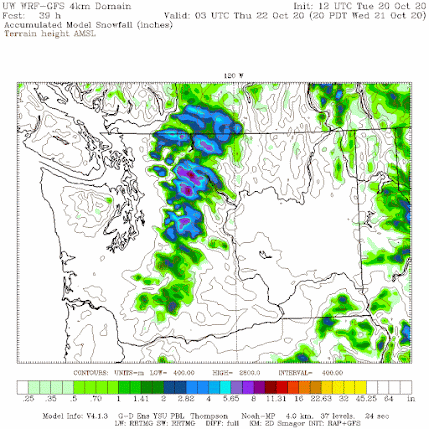
Below is the 24-h snowfall forecast ending 5 PM Friday for the UW high resolution WRF forecasting system.
Wow. 8-12 inches over the Cascades and Olympics, bountiful snow over much of eastern Washington, and even snow at sea level north of Bellingham. High temperatures for Friday will not get out of the 40s.
Some model forecasts are even more aggressive with lowland snow. The latest European Center snow prediction for the same period even brings some snow to Everett (see below).
The sea level pressure pattern forecast for Friday is classic for Puget Sound snow. Below is the sea level pressure forecast (solid lines) for 5 PM Friday. Surface winds are shown as are low-level temperatures (purple is coldest, followed by blue and white).
A favorable (for snow) set up, with low pressure centered over southwest WA, and a large north-south pressure difference over western WA, which will bring in cool air from BC. Not quite perfect for Seattle snow ... having a stronger low on the coast and colder sir in BC would be better.... but who is going to complain in October? A very good pattern for snow east of the Cascade crest.
Early next week the upper-level ridge will strengthen and extend towards the coast, and the trough will push southward towards Arizona. (see upper level map for Tuesday at 5 PM). Expect rapid warming and snow melt here in Washington State.
But there is something very ominous in this evolution. Cold air and associated high pressure will move into the intermountain West and a strong pressure gradient will form over the Sierra Nevada (see surface pressure map, with low level temperatures for 11 AM Monday). Such strong pressure differences could drive powerful winds that might initiate or rev up wildfires in CA. Will have to watch this.
Finally, what was the earliest major snowfall at Sea Tac? It was October 27, 1971 when 2 inches fell. We won't beat on Friday.
________________________________________________
Stream my podcast from your favorite services:
My blog on KNKX and the Undermining of American Freedom is found here. An extraordinary story about Matt Martinez, Director of Content of KNKX, is found here.


I am familiar with that late Oct 1971 snowfall.I had just met my future wife, and we decided to take a walk through lower Woodland Park in Seattle...a romantic time!...and later on towards Winter, Seattle got hit by a much larger snowstorm...it seemed like 8" piled up on the walkway to our apartment, in the Wallingford neighborhood...funny, how memories can be triggered by weather events!
ReplyDeleteThe forecast lows (13-15F) in Spokane on Sunday are pretty nuts for October!
ReplyDeleteThe record low for Sat night is 12F from 1887 and again 12F Sunday night from 1919. Both are probably safe and from a long time ago. Monday's record low is 19F, that one might be in jeopardy. Both before and after those dates the record lows are around 20. Goes to show that it is pretty unusual for those kind of temps at this point.
DeleteSnow cover will be the key to how cold it will get.I had a 14 degree min last year here in Spokane on the 29th,with no snow cover.It would have been in the single digits with appreciable snow cover.Usually,the minimums here will end up 5-8 degrees below from what is initially forecasted,if there is a decent(>2-3")mantle of snow.
DeleteIs this because of Global Warming? Asking for a friend.
ReplyDeleteI still remember a snowfall which occurred in 1984 on South-Central Vancouver Island. The snow started falling on Halloween night and continued until around noon the next day, when it was replaced by a light rain. We ended up with about eight inches of snow if I recall correctly, and I heard my mom explain that a warm front had likely moved in, causing the snow to change to rain. I don't know whether the change was attributable to a warm front or simple diurnal warming. In any case, that snowfall was one of the events which caused me to become interested in meteorology. Incidentally, that early snow set the tone for the winter that followed with at least three other significant snowfalls throughout the winter. One of those, which came around New Years Eve, IIRC, amounted to around fourteen inches, a respectable amount for Vancouver Island.
ReplyDeleteWell, that snow forecast didn't hold together very long. Now calling for rising temps and mostly rain. Boo! Is the Blob to blame?
ReplyDeleteI got to enjoy a few sun snow showers and a rather intense snow squall at around 3600 ASL up near White River campground yesterday. Looking forward to snowshoeing this winter!
ReplyDelete